이곳의 구상화강편마암은 세계적으로 희귀할 뿐만 아니라 학술적으로 매우 중요한데 한국에서 산출되는 구상암석중 무주 오산리 구상화강편마암천연기념물 제249호, 상주 운평리 구상화강암천연기념물 제69호, 부산 전포동 구상반려암천연기념물 제267호 등 3곳이 천연기념물로 지정되어 있다. 본 기념물의 위치는 무주군 오산리 왕정마을 동북방의 계곡 산중턱 고도 320m 지점으로 주로 화강암질 편마암이 분포하고 있으며 함전기석 우백질 편마암으로 구성되었다. 무주 오산리 구상화강편마암에 나타나는 둥근 무늬인 구상은 지름이 5~10cm이고 색깔은 어두운 회색이거나 어두운 녹색이며 일부 주변에 흰색의 외연부를 보여준다. 대부분의 구상암은 화성작용에 의해 만들어지는데 비해 무주 오산리의 구상암은 변성작용에 의해 만들어져 구상암 중에서도 매우 희귀한 경우에 속하며 학술적으로 대단히 중요한 가치를 지니고 있다. 이 고장 사람들은 암석의 표면이 마치 호랑이 무늬를 닮았다하여 "호랑이 바위"라고 부르기도 한다.
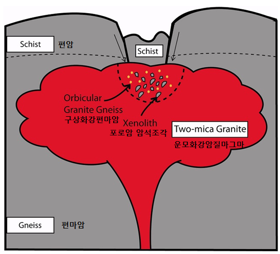
당시 왕정마을 지역은 해양판이 대륙판 밑으로 파고드는 섭입 지역 근처였는데 18억 7500만년 전 대륙충돌이 일어났다. 그 바람에 퇴적암은 땅속 깊이 파묻혀 고온과 고압을 받아 변성암이 됐다. 대륙충돌로 벌어진 지각 틈으로 마그마가 침입했다. 마그마가 지표로 나오는 과정에서 변성퇴적암 조각을 집어삼켰다. 18억 6700만년 전 일이었다. 온도는 약 700도 압력은 6000기압이었다.
만일 마그마의 온도가 훨씬 높았다면 변성암 조각은 모두 마그마 속에 녹아버려 구상암은 형성되지 못했을 것이다. 또 변성암 조각이 적당한 크기였던 것도 표면이 부분적으로 녹은 형태의 구상암을 형성한 요인이었다. 마그마에 뜬 변성퇴적암 조각들이 부분적으로 녹은 상태에서 지표에 올라와 굳었다. 돌이 마그마 위에 떠 있을 수 있던 것은 마그마도 화강암이 녹은 상태이기 때문에 돌조각과 비중이 비슷하기 때문이다. 마치 팥죽 속에 넣은 찹쌀 경단처럼 떠다니다가 굳은 것이다.
This orabicular gneiss in not only rare, but also very important academically. Orbicular rocks in Korea are designated as natural monuments, including the orbicular granite gneiss in Osan-ri, MujuNatural Monument No. 249, the orbicular granite in Unpyeong-riNatural Monument No. 69, and the orbicular gabbro in Jeonpo-dong, BusanNatural Monument No. 267. This monument is located on a mountainside (altitude 320m) in the valley to the northeast of the Wangjeong Village at Osan-ri, Muju-eup. Granite gneiss is widely distributed here, and it consists mostly of tourmaline-bearing leucocratic gneiss. The word orbicular refers to the circular patters on the orbicular granite gneiss. The circles on the orbicular granite gneiss at Osan-ri, Muju are 5~10cm in diameter, and are dark grey or dark green in color, with some of them having white fringes. While most orbicular rocks are formed by igneous activity, the orbicular rock at Osan-ri, Muju was formed through metamotphism, which is very rare among orbicular rocks and therefore has a great deal of academic significance. Local residents call the rock "Horangyi Bawi" (Tiger Rock) as the surface of the rock resembles tiger stripes.
When the continent collision occurred about 1,875 million years ago Wangjeong village area was originally located near the subduction zone where an oceanic crust slides under a continental crust. The sedimentary rock became the metamorphic rock with high temperature and high pressure deep under the surface. The magna intruded into the crust made by continent collision. While the magma erupted above the surface, it capture the pieces of the metamorphic rock. It happened about 1,867 million years ago. At that time the temperature was about 700 degree and the pressure was 6,000 millibar.
If the temperature of magma was much higher, all the pieces of the metamorphic rock would have been melted down not forming the orbicular granite gneiss. The proper size of the metamorphic rock pieces was one of major reason of good formation of the orbicular granite gneiss with the surface of it partially melted down. The metamorphic rock pieces partially melted down and floated inside the magma hardened when it erupted above the surface. The metamorphic rock pieces could float inside the magma as it had the similar gravity with the magma.
구상암에 대한 더 자세한 정보는 아래의 어스캐시들을 참고하세요.
For further detailed information on the orbicular rock, please refer to the following Earth Caches!
Sangju Orbicular Granite(상주 구상화강암) GC6KCJR
Orbicular gabbros at Jeonpodong GC6K1BV
[로그하는 방법]
- Waypoint지점에 가면 사진 A과 같은 바위가 있습니다. (1) 이 바위의 표면에 있는 둥근무늬중 사진 B에 보이는 것의 직경은 얼마입니까? (2) 그렇다면 이 바위의 종류는 다음 중 어느 것일까요? (a.구상화강암, b.구상화강편마암, c.구상반려암)
- 캐시존에 있는 큰 바위를 배경으로 당신 또는 당신의 GPS를 찍은 사진을 로그에 올려주세요. (선택사항이지만 사진을 올려주시기를 부탁드립니다.)
- 답을 제 Profile에 있는 메시지창을 이용해 제게 보내주세요. 이제 로그하셔도 됩니다. 답에 문제가 있을 경우 제가 메시지를 드리겠습니다.


[How to log]
- Go to Waypoint and find a rock in photo A! (1) How big is the diameter of the particle shown in photo B? (2) Then what is this rock? (a.orbicular granite, b.orbicular granite gneiss, c.orbicular gabbro)
- Upload the photo of you or your GPS with the big rock at the cache zone in the background! (The task is optional but I would highly appreciate if you would do so.)
- Please send the answers to me by message on my profile! You may log as 'Found'. If the answer is not correct, I will contact you.
* Refer to : 무주군청, 오창환 외(2013) <대한암석학회지>