Localización
El Parque Nacional de las Islas Atlánticas de Galicia se sitúa en la costa meridional atlántica de Galicia. Esta costa, extremadamente recortada, se conoce con la denominación de Rías Baixas. Las Rías Baixas constituyen un conjunto de profundos entrantes de mar en el continente dispuestos de forma aproximadamente perpendicular a la línea de costa.
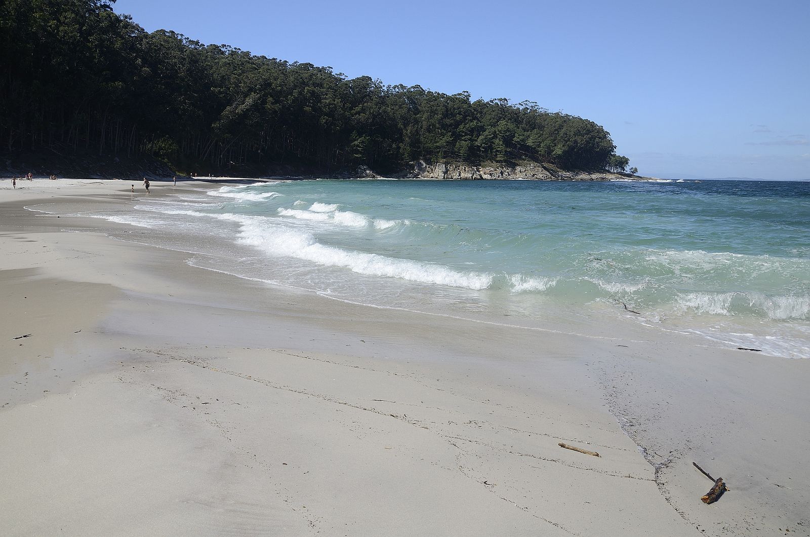
Las islas que constituyen el Parque Nacional de las Islas Atlánticas de Galicia se sitúan en las rías de Arousa, Pontevedra y Vigo. En el exterior de la ría de Vigo se sitúan las islas Cíes. Este conjunto de islas o archipiélago está formado por tres islas, denominadas Norte o Monteagudo, Del Medio o Do Faro, y Sur o San Martiño; las dos primeras se encuentran unidas por un dique artificial.
EVOLUCIÓN DEL RELIEVE A LO LARGO DEL TIEMPO GEOLÓGICO
El inicio del periodo Cuaternario, hace 2,6 millones de años, supuso un cambio notable en las condiciones climáticas produciéndose una sucesión de periodos glaciales separados por periodos interglaciales de clima más templado. Durante los periodos glaciales, el aumento de las masas de hielo terrestres hizo descender el nivel del mar y, por el contrario, en las etapas interglaciales la fusión de las masas de hielo terrestres provocó ascensos del nivel del mar. Esta alternancia de periodos fríos y templados supuso importantes avances y retrocesos de la línea de costa. Estos importantes cambios de temperatura unidos a las variaciones en la línea de costa han influido en las formas del relieve que encontramos en las islas atlánticas de Galicia. La posición relativa de unas formas con respecto a otras permitirá establecer la evolución reciente del relieve de las islas
Geomorfologia
En las islas atlánticas de Galicia, esta situación queda reflejada por la existencia de plataformas de abrasión marina y playas entre 1 y 4 m sobre el nivel del mar actual. Estas formas son registros de la actuación del mar en esas zonas, siendo más tarde abandonadas como consecuencia del posterior descenso del nivel del mar. Los depósitos de playa fósiles, del mismo modo que ocurre en la actualidad, presentan distintos tamaños de sedimentos. Las playas de arena se caracterizan por estar constituidas por arenas de cuarzo muy redondeadas, cementadas por una matriz ferruginosa que da un color anaranjado característico.
Las playas fósiles de cantos están constituidas por cantos y bloques redondeados y cementados por una matriz arenosa. Estas playas fósiles se presentan en afloramientos de escasas dimensiones. En las islas Cíes, entre la playa de Rodas y la punta de Ferreiros, se han localizado numerosos afloramientos de playas de arenas y cantos fósiles. La cartografía de estos afloramientos muestra que la línea de costa de las islas durante el Eemiense tenía una posición muy similar a la actual
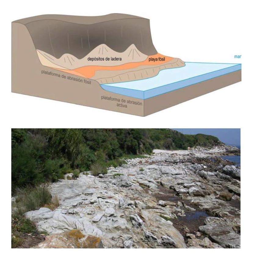
1. Periodo interglacial eemiense (128000 - 117000 años). Nivel del mar aproximadamente 4 metros más alto que en la actualidad. Erosión de acantilados, furnas y plataformas de abrasión marina, y sedimentación de playas de arena
2. Inicio del periodo glacial würmiense (aprox. 117 000 años). Descenso del nivel del mar. Recubrimiento, por depósitos de ladera, de los antiguos acantilados, furnas, plataformas de abrasión marina y playas eemienses.
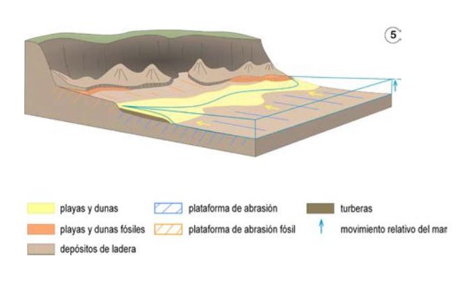
3. Máximo glacial würmiense (aprox. 18 000 años). Nivel del mar aproximadamente 120 metros más bajo que en la actualidad. Desarrollo, en extensas llanuras litorales, de grandes playas, campos de dunas y zonas encharcadas.
4. Transgresión flandriense (18 000 años-actualidad). Ascenso del nivel del mar. Desplazamiento tierra adentro de la línea de costa con las playas, campos de dunas y zonas encharcadas asociadas
5. Actualidad. Erosión de las formas del relieve würmienses y eemienses
Para logar este EarthCache, envíame un correo electrónico con la respuesta a las siguientes preguntas:
1) Describe muy brevemente el proceso que llevó a la formación de estas playas fosiles
2) ¿Cual es la antiguedad de estas formaciones? Describe las playa fosil: Textura, color ...
3) Dime las dimensiones aproximadas de la playa fosil que podemos ver aquí. ( Ancho, Largo y ancho)
-Si crees que as concluido con exito los objetivos de este Earth Cache, y me ha enviado todas las respuestas solicitadas, puede hacer el log. Luego yo comprobaré que son correctas, y si hay cualquier problema me pondre en contacto para arreglarlo.
-Logs sin respuestas enviadas previamente, seran borrados sin aviso
-Las fotos son opcionales, pero se agradecen y ayudan a verificar la visita
English (GoogleTranslate)
Location
The Atlantic Islands of Galicia National Park is situated on the southern Atlantic coast of Galicia. This coast, extremely trimmed, known under the name of Rias Baixas. Rias Baixas are a set of deep sea inlets in the continent arranged approximately perpendicular to the coastline.
The islands that make up the Atlantic Islands of Galicia National Park is located in the estuaries of Arousa, Pontevedra and Vigo. Outside of the estuary of Vigo Cies Islands are located. This group of islands or archipelago consists of three islands, called Northern or Monteagudo, Del Medio or Do Faro, and San Martiño or South; the first two are joined by an artificial dam.
EVOLUTION OF RELIEF OVER THE GEOLOGICAL TIME
The beginning of the Quaternary period, 2.6 million years ago, was a marked change in climatic conditions produced a succession of glacial periods separated by interglacial periods of milder weather. During glacial periods, increased terrestrial ice masses lowered sea level and, conversely, in the interglacial stages melting ice land masses caused promotion of sea level. This alternation of cold and warm periods brought about important advances and retreats of the coastline. These important changes in temperature linked to variations in the coastline have influenced landforms found in the Atlantic islands of Galicia. The relative position of some forms over others will establish the recent evolution of the relief of the islands
Geomorphology
In the Atlantic islands of Galicia, this situation is reflected by the existence of marine abrasion platforms and beaches between 1 and 4 m above the current sea. These forms are records of the performance of the sea in these areas, being later abandoned as a result of the subsequent decline of sea level. Fossil deposits beach, the same manner as at present, they have different sizes sediment. The sandy beaches are characterized by being constituted by very rounded quartz sand, cemented by a ferruginous matrix that gives a distinctive orange color.
Fossil pebble beaches are formed by edges and rounded blocks and cemented by a sandy matrix. These fossil beaches are presented in outcrops of small size. In the Cies Islands, between the beach of Rhodes and the tip of Ferreiros, they have located numerous outcrops of sandy beaches and fossils songs. The mapping of these outcrops shows that the coastline of the islands during the Eemian had a very similar position to the current
1. Eemian interglacial period (128,000 to 117,000 years). Sea level higher than about 4 today meters. Erosion of cliffs, Furnas and marine abrasion platforms, and sedimentation of sandy beaches
2. Starting the Würm glacial period (approx. 117 000 years). Decline in sea level. Coating, deposits slope of the ancient cliffs, Furnas, marine abrasion platforms and Eemian beaches.
3. Würm glacial maximum (approx. 18 000 years). Sea level about 120 meters lower than today. Development, extensive coastal plains, great beaches, sand dunes and flooded areas.
4. Flandrian Transgression (currently 18,000-years). Rise of sea level. Displacement inland from the coastline with beaches, sand dunes and flooded areas associated
5. Present. Erosion forms of relief and Eemian würmienses
To log this earthcache, send me an email with the answer to the following questions:
1) Describe briefly the process that led to the formation of these fossil beaches
2) What is the antiquity of these formations? Describes the fossil beach: texture, color ...
3) Tell me the approximate dimensions of the fossil beach we can see here. (Width, length and width)
-If you believe you have successfully completed this Earth Cache goals and has alreadysent to me all the requirements as requested, Please, feel free to log it as found. Later i will verify the requirements sent and, if necessary, contact you in order to make the necessary corrections to your log.
-Logs without answers, will be deleted without notice.
-Pictures are optional, but they are welcome and will be usefull to verify you visit
|
Sources:
-wikipedia
-Guia geologica
|