[JP]
平尾台は福岡県北東部に位置する、標高370~710m、台上面積約12km²の結晶質石灰岩からなるカルスト台地です(Wikipedia. 以下同様)。
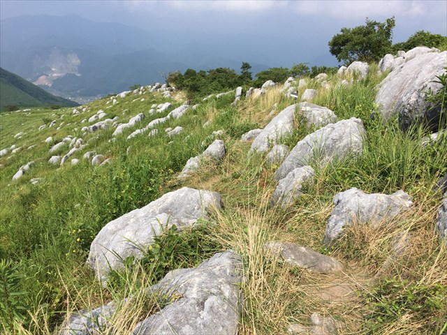
公開座標は大平山山頂で、ここからは多数のピナクルを観察することができ、羊の群れのように見えることから、羊群原と呼ばれます(下写真は山頂から若干下った場所で撮った写真です)。
[EN]
Hiraodai is a Karst tableland located at North-East of Fukuoka prefecture, having altitudes between 370-710m above sea level, an area of 12 square kilometers.
The published coords, GZ is at the top of Mt. Ohira, from where you can observe a lot of pinnacles . Such a group of pinnacles looks like "sheep", thus here is called as "sheep field"(see the picture below, which was taken on the trail somewhat lower than the top.)
カルスト地形とは?/What is Karst?
[JP]
カルスト地形とは、石灰岩などの水に溶解しやすい岩石で構成された大地が雨水、地表水、土壌水、地下水などによって侵食(主として溶食)されてできた地形(鍾乳洞などの地下地形を含む)です。カルスト地形に特徴的な地形構造には以下のようなものがあります。
- ドリーネ: 雨水が石灰岩の割れ目に沿って集中的に地下に浸透する過程で周囲の石灰岩を溶かすことにより形成されたすり鉢型の窪地
- ピナクル: 地面を覆う岩石のうち一部が溶けずに残り、その部分だけが地面から飛び出した岩柱
- カレン: 溶食が進んだ岩石の表面に形成された溝。多数のカレンが見られる地形をカレンフェルトという
[EN]
Karst is a land feature (including underground land features, like underground cavern) formed with soluble bedrocks like limestone which dissolve by acid water like rain water etc. Karst often has characteristic land features as below:
- Doline: A depression or hole in the ground caused by the chemical dissolution of carbonate rocks.
- Pinnacle: A rock tower which remains after dissolution of the bedrock.
- Karren: Gutters formed on rock surfaces by dissolution.
石灰岩はどこから来た?/Where did the limestone come from?
[JP]
平尾台の石灰岩はどこから来たのでしょうか?それは遠い海の底からです。どのようにして、遠い海の底で石灰岩が出来て、日本までやってきたのかを以下に説明いたします。
[EN]
From where has the limestone of Hiraodai come? It has come from the deep bottom of the sea far from Japan. How the limestone was formed there and has come to Japan will be explained below.
[JP]
日本列島の大部分は付加体により形成されたと考えられています。付加体とは何かについて下図を参照して説明します。
[EN]
It is thought that most part of Japan has been formed with "accretionary prism". What "accretionary prism is will be explained with reference to the figure below.

[JP]
Stage 1:マグマが海嶺(海底の割れ目)からあふれて固まり、海洋プレート(この場合は太平洋プレート)を形成します。海洋プレートは海嶺から離れるように移動します。この海洋プレートの移動を駆動する力の95%は、海洋プレートの他端が上図左側の海溝においてマントル内に落ち込むことにより生じる引張力であると考えられています。
Stage 2:海底火山の上に成長したサンゴ、有孔虫、円石藻などの死骸が海洋プレート上に堆積します。この堆積物は後にチャートや石灰岩となります。
Stage 3:徐々に陸地に近づくにつれて、陸上の火山からの火山灰が降り積もります。また、陸地から比較的遠い位置では、陸上から流されてくる砂や泥のうち、比較的沈降しにくい粒径の小さい泥が堆積します。但し、大地震などによって海底で発生する海底地すべり(タービディティ・カレント)や洪水などの作用により、陸地から遠い場所まで砂が運ばれて、泥層の上に砂層が堆積することがあります。長い年月をかけて何度も大地震や洪水が発生して泥層と砂層とが繰り返し堆積することにより、砂岩泥岩互層が生み出されます。
Stage 4:さらに陸地に近づくと、粒子の粗い砂が、火山灰や泥の上に堆積します。
付加体形成:海洋プレートが大陸プレート(この場合はユーラシアプレート)の下に沈み込むときに、海洋プレート上の種々の堆積物は、大陸プレートによってかきとられて混ざり合い、大陸側に盛られていきます。この盛られた地質は「付加体」と呼ばれ、日本列島の土台を構成しています。
[EN]
Stage 1:Magma coming out of oceanic ridge (fissure in the bea bed) gets solidated and forms oceanic plates (e.g. Pacific plates). Oceanic plates move away from the oceanic ridge. 95% of the force driving the movement of the oceanic plates is pulling force caused by the other end of the oceanic plate falling into the mantle at the oceanic trench (see the left side of the figure above).
Stage 2:Shells of dead organisms, like corals growing on submarine volcanoes, coccolithophore, foraminifer etc. deposit on the oceanic plates. The deposited sediment becomes chert or limestone later.
Stage 3:With approaching to land, volcanic ashes from volcanoes on the land fall and deposit. In addition, when it is still relatively far from the land, among sand and mud coming from the land (e.g. carried by river flows), less sedimentable particles with a fine grain size, i.e. mud, deposit. However, due to turbidity currents (submarine land slides) caused by major earthquakes, and to floods etc., sand is carried far from the land and deposits on the mud layer already deposited. Over the years, many earthquakes and floods happen and sand layers and mud layers deposit alternately, thus generating a structure in which sandstone layers and mud layers alternate.
Stage 4:When approaching closer to the land, rough grained particles (sand) coming from the land deposit on the volcanic layers and mud layers.
Formation of accretionary prism:When the oceanic plate sinks under a continental plate (in this case, Eurasian plate), the sediments on the oceanic plate are mixed with each other and accreted onto the continental plate. The accreted sediments are called a “accretionary prism” and form the base of Japan.
[JP]
上記のStage 2で形成されて日本までやって来て、付加体となった石灰岩が、各地でカルスト地形を形成しています。中でも、秋吉台カルスト、平尾台カルスト及び四国カルストが日本三大カルストと呼ばれています。
[EN]
Limestome formed in "Stage 2" above came to Japan, became the accretionary prism and has formed Karst in various places in Japan. Among others, Akiyoshidai Karst, Hiraodai Karst and Shikoku Karst are called as "three main Karsts in Japan".
平尾台カルストの特徴/Characteristics of Hiraodai Karst
[JP]
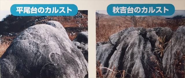
これらのカルストの中でも、平尾台カルストは、マグマの熱の影響を受けて結晶化しているという特徴があります。そのため、秋吉台カルストなどでは石灰岩の元となった生物の化石を観察することができますが、平尾台カルストでは、熱によって石灰岩が結晶化したため、そのような化石は観察されません。
[EN]
Among these Karsts, Hiraodai Karst is characterized in that it has been crystallized with the heat of magma. Therefore, while at Akiyoshidai you can observe fossils of creatures resulting in the limestone, you cannot find such fossils at Hiraodai Karst, because the limestone in Hiraodai has been crystallized with the heat of magma.
タスク/Task
[Task 1]
[JP]
以下のクイズの答えをキャッシュオーナーに送ってください。
Q : 平尾台のピナクルと秋吉台のピナクルを比較すると(下写真参照)、秋吉台のピナクルは頂上がとがっているのに対して、平尾台のピナクルは頂上が丸みを帯びています。何故、平尾台のピナクルは頂上が丸みを帯びているのでしょうか?上記で説明されている平尾台カルストの特徴を考慮しつつ、平尾台のピナクルの表面を実際に観察して、答えてください(写真の観察だけでは十分な解答を得ることは出来ません。実際に平尾台を訪れて、現地のピナクルの表面を観察してください)。
[EN]
Send your answer for the quiz below to the cache owner.
Q. Comparing pinnacles at Hiraodai an Akiyoshidai (see the picture below. The left is a Hiraodai pinnacle, the right is an Akiyoshidai pinnacle), while Akiyoshidai pinnacles have acuate tops, Hiraodai pinnacles have round tops. Why do Hiraodai pinnacles have round tops? Please visit Hiraodai in person and answer by observing actual surfaces of Hiraodai pinnacles, as well as by taking into consideration the characteristics of Hiraodai Karst explained above (You cannot get any sufficient answer if you only look at the picture below. You have to closely look into actual surfaces of pinnacles around GZ).
[Task 2](Option)
[JP]
公開座標から写真を撮ってログと共にアップロードしてください。
[EN]
Take a picture from GZ and upload it with your Found log.