Please note Use of geocaching.com services is subject to the terms and conditions
in our disclaimer.
Better eat your pudding! This "Polished Pudding" Earthcache will make you climb to the top of Schunemunk Mountain, to check out some colorful pudding stone (conglomerate) that has been worn down and polished by glacial erosion!
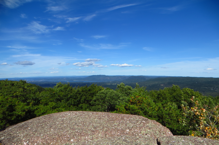
There are no drive-by shortcuts on this one, and Schunemunk is a pretty mean little climb, no matter from which side you ascend. But it is also my favorite hilltop in the region, and the pitch pine studded views over the Hudson Valley and beyond are just awesome. So ... go take a hike, and get yourself an Earthcache smiley!
To complete this Earthcache, you have to visit three waypoints along the ridge, and answer the associated questions. Don't fret, in comparison to the climb to get up there in the first place, the hike along the ridge is childs play and outright pleasant :). And, like with all of my Earthcache hides, I am not looking for perfect scientific answers, just for evidence that you made personal observations on site, and gave the questions some thought. If you are lazy and in an unimaginative kind of mood, you can also ignore the "bonus" questions, but please mention in your log if you decide to take this shortcut.
Waypoint #1 (posted coordinates) is right at the intersection where the Jessup Trail and Sweet Clover Trail meet. It is also a spot that features a pretty decent view, and invites to sit down and take a break after the climb. There is a prominent 90deg angled white trail marker painted onto the conglomerate rock, to indicate that the Sweet Clover Trail turns here.
Q1) Look for the white quarz embedded in the puddingstone, directly adjacent to the white trail marker painted onto the rock. Are the quartz pieces: pea, marble, golfball, baseball or football sized ?
Q1bonus) 10ft to the NNE, the conglomerate looks different and a lot less smooth. Why do you think this is the case?
Waypoint #2 (N 41° 23.665 W 074° 06.745, also listed as waypoint below) is along the Jessup Trail, where a little (~4ft) boulder sits on the high point of the pudding stone outcrop.
Q2) Is this a glacial erratic? Why / Why not ?
Q2bonus) Where do you think this boulder came from, and how did it get here?
Waypoint #3(N 41° 23.558 W 074° 06.964 , also listed as waypoint below) is at the trail intersection to the Megaliths. Here, you'll find some of the better "polished pudding" on the ridge, conglomerate that was scraped and worn down by glacial erosion. Look for smoothly polished patches of puddingstone within 20ft or so of the trail intersection.
Q3) Why do you think the smoothest rock is right here?
Q3bonus) What do you think kept some sections of the rock here so smooth and shiny?
Please post pictures of pudding stone both coarse and smooth ... but kindly pick your angle in a way that keeps the armchair loggers guessing!
So far for the Earthcache Questions. But if this is your first visit up here, by all means DO hike out the 0.1mi to the Megaliths, one of the best sites and views along the ridge!
Take note that Schunemunk allows hunting while in season, roughly Oct 1 - Dec 31. Wear orange, and don't stray off the marked trail, particularly not when hiking on the western ridge!
This Earthcache is approved by Park Management and has Permit # GC-127-SCH, issued July 17, 2017
Geology of Schunemunk Mountain
Schunemunk Mountain is at the northern end of what Geologists call the "Green Pond Outlier", a 60mile SW/NE trending, narrow ridge of sedimentary rocks. The base of the ridge is formed by Devonian (~400mio yrs ago) sandstones, and it is capped by a colorful conglomerate (pudding stone) from the same epoch, named "Schunemunk Conglomerate" after its location of prominence. The nearby hills of the Hudson Highlands are underlain by much older rocks, in comparison.
Schunemunk Conglomerate consists mainly of prominent white quartz pebbles and red sandstone cobbles, embedded in grey-pinkish sandstone "cement". Along the ridge, the shape (round versus jagged) and the size (tiny up to huge) size of the embedded cobbles differs quite a bit. Conglomerate is a sedimentary rock, meaning that it formed out of debris of ancient mountains that was carried downstream to a lake or ocean. There are three main kinds of sedimentary rocks: Mudstones, made from micro-fine silt, form at the very edge of lakes, where there is basically no current. Sandstones form in shallow slow moving water, think river deltas and beaches. Conglomerate (pudding stone) forms in deep channels or outer bends of fast moving streams, where the current is strong enough to carry and deposit fist-sized cobbles.
For puddingstone, once the gravel is accumulated, the space between the cobbles gets filled with finer sediment (sand and mud). The sediments initially are still inundated by mineral rich ground water, whose particles settle and help to bind the sand together, a process called "cementation". While more and more cobbles and sediments on top continue to add more weight and pressure, the layers down below get compressed, in a process called "compaction". Both "cementation" and "compaction" together result in "lithification", loosely translated as "turning into rock". Voilà: Gravel to Conglomerate!
Schunemunk Mountain has an added unique feature insofar as it has a double crest. Depending on your approach path, you will very much notice that there are two mountains to climb, with Baby Brook Valley in between. This double-ridge is the result of folding action that occurred in the Alleghenian Orogeny (~260 mio years ago).
And, of course, Schunemunk Mountain was scraped ripped roughed and shaped by glaciers during the last ice age (a measly ~13'000 years ago). Advancing glaciers pack a truly hefty wallop, and together with rock debris that adds friction, glaciers are an awesomely irresistible force. The last ice age with its grinding removing and depositing powers shaped most of the earth surface in New York State that we know today. Running roughshod over a mountain range, glaciers can gouge or polish the bedrock, to the extent that even extremely hard quartz pebbles are shorn off and worn down, until a totally smooth and flush surface results. Glaciers can also break off chunks of native rock, and transport them miles and miles from their place of origin. Once the glacier melts, these rocks settle down, and remain behind as so-called "glacial erratics", a rock that obviously differs in size and composition from the rock on which it rests.
Source: A geological climb of Schunemunk Mountain. New York State Geological Association. 1989. William J Tucci and Robert Kalin.
Source: Understanding Earth, Fifth Edition, Grotzinger Jordan Press Siever
Source: Roadside Geology of New York, Bradford B. Van Diver
Additional Hints
(No hints available.)