Thousands of footprints left by early Maori, some hurrying in war parties, some fleeing from tribal warfare and many proceeding in peace, help to stamp the trail which became the whakaahurangi track.
This reknown ancient pathway, was the principal Maori highway in Taranaki between Kairoa Pa near Lepperton, and Ketemarae Pa near Normanby, from the 16th to the 19th centuries.
Nothing of the track exists now after destruction from farming and roading, although it would have certainly have disappeared when the bush was burnt off to create arable land in the 19th century.
For the previous 300 years it was the only recognised clear route from coastal North Taranaki to South Taranaki if travellers wished to avoid the Taranaki tribes. This inland pathway was about (a metre) wide and was kept clear by travellers constantly bending twigs or nipping buds of overgrowth as they proceeded along it.
There are a number of origins of the name Whakaahurangi, and tradition records it being named after Ngati Ruanui kahurangi Ruaputahanga returning home from Kawhia about 1560 to Patea. Travelling along the track her party stopped for the night near Midhirst. Laying on her back with her face to the sky giving the name Whakaahu (to turn towards) rangi (the heavens) to mark her resting place and the track.
The track was widely known and well used. Several large heke from Auckland and Waikato used it. Te Rauparaha brought what must have been one of the largest parties when, about 1820, he led 2000 men, women and children of the Ngati-toa tribe from Kawhia to take possession of Kapiti island.
The going was often arduous with no bridges over the many steams and rivers which had to be crossed. Often it would have been wet and muddy. Yet it was generally recognised as being a safe route and the difficulties similar to other prominent New Zeland routes.
The track had fallen into disuse upon European settlement, but in 1842, New Zealand Company Agent John Wicksteed employed the Nairn brothers employing Maori labourers to cut a bridle path along its route despite opposition from Maori and others such as Wesleyan missionary John Skevington.
It became overgrown during the Taranaki Wars, but Major-General Chute led a mixed force from Ketemarae to New Plymouth in 1866. Finding the trail almost obliterated by overgrowth, he made slow progress bridging the numerous swamps, gullies and streams and cutting a passable road.
State Highway 3a and 3 between Waitara and Hawera roughly follows the route of old road.
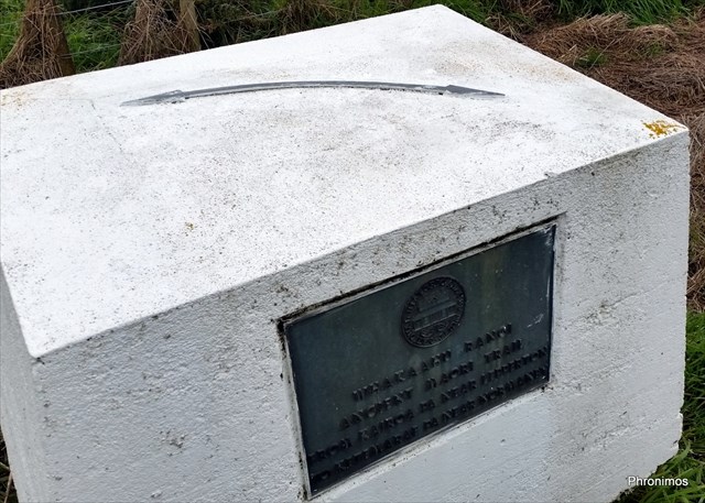
In March 1959 a NZ Historic Places plaque was placed here approximately where the Whakaahurangi trail crossed the Stratford to Ohura road. There's a nearby Heritage Trails sign displaying the four prominent ancient trails in Taranaki.
Source: Taranaki Herald 21 March 1959, Footprints of Three Centuries. Retrieved 20/07/2016; URL: Kete New Plymouth: Heritage Sites and Features Whakaahurangi Trail Plaque - 1959. Filename: Whakaahurangi_Unveil.pdf
Retrieved 20/07/2016; URL: Kete New Plymouth: Heritage Sites and Features Whakaahurangi Trail Plaque - 1959.