Revitalizing the Grindstone Marsh Delta
Marshes provide habitat for many species of plants, animals, and insects that have adapted to living in flooded conditions. The plants must be able to survive in wet mud with low oxygen levels. Many of these plants therefore have straw like channels within their stem that allow air to move from the leaves into the rooting zone. Marsh plants also tend to have rhizomes (root like tubers) for spreading and creating new plants, such as cattails, sedges, and sawgrass. Marshes are home for a variety of invertebrates, fish, amphibians, waterfowl and aquatic mammals, and improve water quality by filtering pollutants and sediments from the water that flows through them. Marshes help reduce flooding, by absorbing water during periods of heavy rainfall and release it slowly into into the waterways.
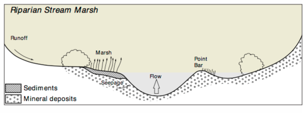
The marsh you see before you is an example of a Riparian Stream Marsh.
These marshes are located on embankments, channels, islands or stream bed materials on first, second or third order water courses with continuous or intermittent flow. Stream marshes are usually found on recent alluvial sediments deposited in protected areas not influenced by strong water currents.
The Christmas Tree Project
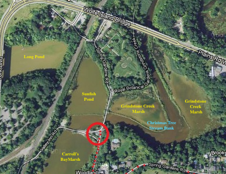
This project is located at the mouth of Grindstone Creek in the Hendrie Valley Sanctuary. The loss of wetland plants resulted in the loss of the last several kilometres of wetland river channel at the Grindstone Creek Delta.
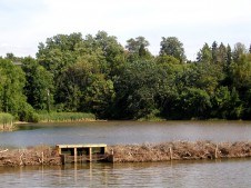
In January of 2000, the RBG implemented an experimental wetland restoration project re-establishing a portion of the channel and creating carp barriers to protect a portion of the wetland. Used Christmas trees, collected by local municipalities, were formed into riverbanks, helping to recreate the natural channel and three wetland regions. Five small carp barrier structures where inserted into the banks blocking carp access to the wetlands while maintaining the natural flow of water and movement of organisms. If you are here when the carp are spawning, you will see just how effective these barriers are. In January 2001 in the Valley Inn Area, the Christmas tree barrier project entered its final phase, crossing Sunfish Pond/Long Pond - the historical outflow link from adjacent Cootes Paradise. Through this project, 13 hectares (32 acres) of wetland habitat are being recreated at the Grindstone Creek Delta. The new habitat allows for the return of abundant plant growth and already attracts wetland wildlife, migrating water birds and spawning fish. Over time, the Christmas trees naturally biodegrade, leaving a build-up of sediment and reeds as a riverbank.
Geology
The Geology of Hendrie Valley is quite interesting, as the two sides of the valley are distinctly different. The South side is a post-glacial sandbar, while lake-bottom clay and silts form the North slope. As a result, each support a unique and diverse combination of plant species.
To log this EarthCache, you must send the answers to the following questions, to the CO at the top of the page. Do not post your answers in your log. Any “Found it” log without answers sent to the CO will be deleted.
At the Posted Coordinates:
1) According to the signage at the posted coordinates, what are some of the key stresses on the Grindstone Marsh Delta
2) How many Christmas Trees were used in the construction of the berm (artificial stream bank).
3) What is the goal of Project Paradise?
4) Looking east, at the Grindstone Marshes, estimate the percentage of vegetation cover vs open water behind the artificial Christmas tree barrier. Then, looking west, Sunfish Pond, again estimate the percentage of surface area that is open water, with that covered in vegetation. Which one do you think has had a better recovery.
At Stage 2
5) Since what year have scientists and partners been working on the restoration of the lower Grindstone creek wetlands.
6) In 2005, what formerly extirpated animal nested and raised their young?
7) What is the length of the new stream bank created by the Christmas trees
8) Describe what you notice is the difference in the type of vegetation between the south side post-glacial sandbar, and the north slope.
Please remember, in order to log this EarthCache, you must send the answers to the above questions, to the CO at the top of the page.
Thank-you for Visiting this EarthCache!