
UA : Глинами називають мінеральні маси, які утворюють з водою пластичне тісто і зберігають надану їм форму після висихання, а при випалюванні втрачають воду і набувають механічну міцність.
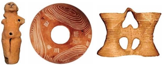
Людство використовує пластичну властивість глини з прадавніх часів. Так археологічні знахідки кераміки Трипільскої культури датуються біля 3500 років до нашої ери.
Глини є продуктом руйнування гірських порід під впливом води, повітря, температури і інших чинників. Ці продукти вивітрювання переносяться атмосферними водами і річками. Зустрічаючи на своєму шляху поглиблення, глинисті частки відкладаються, заповнюючи їх і утворюючи потужні родовища. Якщо місця відкладень незначні, то родовища, що утворюються, мають форму лінз.
Оскільки умови утворення родовищ глин були різними, глини відрізняються гранулометричним і мінералогічним складом і, як наслідок, - різними хімічними і фізичними властивостями.
Наприклад, колір глин визначається головним чином наявністю в їх складі оксидів заліза. Жовтий, червоний і червоно-бурий колір глини - це наявність в її складі Fe2O3. А от блакитно-зелені відтінки кольору - це наявність у складі глини FeO. Крім оксидів заліза, на колір глин впливають оксиди титану, марганцю та ін. Гумус і органічні речовини забарвлюють глини в сірий колір.
Але основною властивістю глини є її пластичність, тобто здатність приймати форму, яку їй надають.
За даними книги С.Потапенко («Глины и глинистые породы Украинской ССР». К. 1952) серед різноманітних глинистих порід України значне місце займають мергелисті глини, що приурочені до нижнєтретичних морських відкладень київського ярусу. Такі глини ще відомі в літературі під назвою "спонділова глина". Таку назву "спонділова" глина отримала через включення залишків мушлі Spondylus buchim.
У Київській області спонділова глина залягає неглибоко від денної поверхні. Повністю вона оголюється на правому березі Дніпра, починаючи від села Старі Петрівці і далі вниз за течією Дніпра, майже до м.Кременчука. Глини київського ярусу можна розділити на два горизонти. Перший, так званий, наглинок (потужність 1 - 8м), другий - мергелиста глина (середня потужність якої дорівнює 20- 25 м). Зазначимо, що забруднена різними домішками спонділова глина називається "лес"
Для північно - східних областей України (включаючи Київську) розріз відкладень приблизно наступний:
- Типовий лес - до 10 м
- Піскуватий грунт - 0,5- 1 м
- Лес 2-го горизонту - 10-15 м
- Підлесовий пісок - 1 – 2 м
- Суглинки – 3 – 6 м
- Бура глина - 1 - 3 м
Відкладення лесового комплексу поширені в Києві на правому березі Дніпра від Лук'янівки до Печерська. А в районі Корчуватого лес залягає на мергелистій глині.
EN: Clay is such a natural mineral mass, which forms a dough when mixed with water. We can take the form of this dough, which will remain after drying. After firing the clay loses water and becomes mechanical strength.
Humans uses the plastic properties of the clay from ancient times. Since the ceramic archaeological finds of the Tripoli culture date back to around 3500 years BC.
Clay is a product of rock destruction under the influence of water, air, temperature and other factors. These products are transferred by atmospheric water and rivers. Clay particles with water is retained in the voids and created a powerful fields. Sometimes, these deposits have a lens shape.
The properties of the clay depend on the source rock from which they are formed and the water, which transferred the clay particles. Therefore, the clay deposits have of different particle size and mineralogical composition, as well as the various chemical and physical properties.
For example, the color of clay determine the iron oxides, titanium oxides, manganese, etc. Fe2O3 in composition of clay dyed the clay in yellow, red and reddish-brown color. The clay is bluish green if contain FeO. The humus and organic matter dyed the clay in gray color.
The main feature of the clay is its plasticity, or in other words - the ability to take the form that is needed to human.
According to the book (С.Потапенко «Глины и глинистые породы Украинской ССР». К. 1952) has a lot of the deposits of the clay marl in Ukraine. The emergence of this clay refers to Lower Tertiary marine sediments Kiev tier. Thus, the term " spondilus clay" , also used in the literature (because this clay has a lot of inclusions of particles from shells Spondylus buchi).
If marly clay has contaminated by other larger mineral substances, such clay called loess.
The Clays of the Kiev tier can be divided into two express horizon. First Horizon called up-clay ("naglinok") and has a capacity of 1-8 Meters. The second horizon - this is the marly clay. The capacity of this horizon could be 20 to 25 m.
The Kiev region has the section of the deposits of the clay similar to the following:
- Typical loess is up to 10 meters
- Sandy soil is 0.5 to 1 meter
- Loess of the 2nd horizon is of 10-15 meters
- Under Loess sand is 1 - 2 meters
- Loam is 3 -6 meters
- Brown clay is 1 - 3 m
Deposits of the loess clay distributed in Kiev on the right bank of the Dnieper from the Lukyanovka district to the Pechersk district. A near Korchuvate district the loess clay lies on pure of the marl clay.
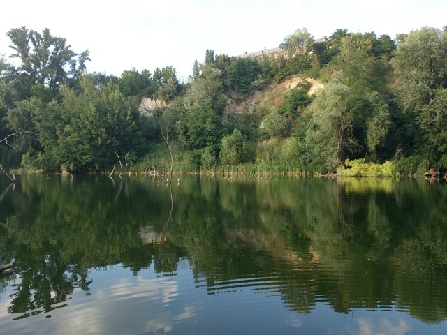
UA: В центрі сучасного Києва, на кордоні між Печерським та Голосіївським районами є не велике та, навіть, мальовниче озеро під назвою «Глинка». Глибина озера досягає 10 метрів. Історія появи цього озера має безпосереднє відношення до використанні глини людиною.
Не зважаючи на те, що поблизу від цього місця протікає річка Либідь, живиться озеро виключно підземними джерелами. Тому вода в озері прозора та прохолодна навіть в літню спеку. На мапі Києва це озеро з’явилось на початку 19 сторіччя під час «будівельної лихоманки».
EN: Not great and even the picturesque lake called "Glinka" is in the center of modern Kyiv, on the border between the Pechersky and Golosiivsky districts. The depth of the lake is 10 meters. The story of this lake is directly related to using the clay by human.
Despite the fact that not far from this place is Lybid river, lake fed only by underground springs. Therefore, water in the lake is clear and cool even in the summer heat. Lake appeared on the Kyiv map in the early 19th century during the "construction fever".
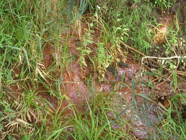
UA: В деяких місцях на берегу озера джерела виходять на поверхню, тому тут можна побачити грунт характерного кольору.
********************************
Отже, для пошуку цього схову Вам необхідно відвідати це місце, з’ясувати та надіслати на мою поштову адресу через сайт geocaching.com відповіді на деякі запитання:
1. Знайдіть на березі озера місце, де підземне джерело виходить на поверхню. В який колір та завдяки яким мінеральним сполукам глини вода підземного джерела фарбує грунт?
2. Назва озера «Глинка» свідчить про те, що тут видобували глину. Якого типу глину, коли та з якою метою тут видобували? Обгрунтуйте свою відповідь відповідними фактами. Google стане Вам у допомозі.
Ви можете, але не зобов’язані, зробити власну фотографію озера та додати її до свого логу.
Мені було б приємно, якщо в полі зору Вашого фотоапарату попаде будинок з жовтої цегли на вершині пагорбу 
********************************
EN: In some places on the shore of Lake underground springs go to the surface, so you can see typical color of the soil.
********************************
So, to find this cache, you need to visit the hiding place, find out and send to my email address via the website geocaching.com answers to some questions:
1. You need to find the place on the shore of the lake where underground springs go to the surface . In what color the water painted soil? Name the mineral compounds of the clay which to painted the soil in this characteristic color?
2. Name of the lake "Glinka" indicates that human mined a clay in this place. What type of the clay, when and for what purpose mined here? Justify your answer by relevant facts. You can to use the Google system for this question
You can, but not required, to make your own photo of the lake and add it to your log.
I will be very glad if your camera "grabs" the yellow brick's house on a top of the hill.
********************************
Happy caching!
