To claim and log this Earth Cache you need to answer the following four questions and e-mail your answers via my Geocaching profile.
1. How many large bands of sedimentary rocks can you see at GZ?
2. Explain why the Graafwater formation consists of alternating bands of sandstone, siltstone and mudstone.?
3. Explain why the silt stones and mudstones of the Graafwater formation are reddish in colour while the sandstones are grey or brown.?
4. Evidence of faulting that can be seen close to GZ. Either submit a photograph with your answers, or accurately describe the evidence you have observed.
5. Uploading photos to the cache page is the best way to say thank you to the cache developer and to encourage others to visit the location but is only optional.
Table Mountain Road
This road falls under the category of a suburban pass and after a short steep ascent from Kloof Nek it climbs rapidly via two 180 degree hairpins to level out at the lower cableway station.
Thereafter it runs more or less on an even contour line all along the north face of Table Mountain. Some years ago, rock slides caused the the road to be closed at the 4,1 km mark, leaving the remainder of the eastern section open only to hikers and cyclists. The total length to the end of Tafelberg Road is 6,37 km. The average gradient is a very pleasant 1:36.
The road provides unparalleled views of Cape Town, the harbour, Robben island and the Cape Flats.
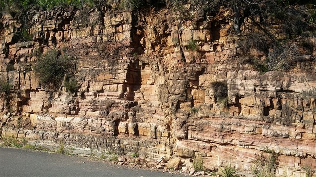 GZ will take you to a cutting on Table Mountain Road where you can see the amazing layered picture of sedimentary deposits over a base of granite laid down over millennia.
The Table Mountain Group
A large part of the mountain side is in fact, the lower portion of the Table Mountain Group namely the Graafwater Formation which consists of relatively soft intermingled layers of brown sandstone pink siltstone and maroon coloured shale (laid down some 450 million years ago) overlaying the granite which forms the base layer of this part of the peninsula – the granite which forms an undulating platform dates back over 600 million years.
GZ will take you to a cutting on Table Mountain Road where you can see the amazing layered picture of sedimentary deposits over a base of granite laid down over millennia.
The Table Mountain Group
A large part of the mountain side is in fact, the lower portion of the Table Mountain Group namely the Graafwater Formation which consists of relatively soft intermingled layers of brown sandstone pink siltstone and maroon coloured shale (laid down some 450 million years ago) overlaying the granite which forms the base layer of this part of the peninsula – the granite which forms an undulating platform dates back over 600 million years.
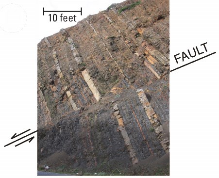
An occasional feature of these rocks is the presence of steep faults that displace the beds. The contact between the granite and the overlying beds is irregular, with the sediments occasionally occupying depressions on the granite surface. Good examples of this feature can be seen along Table Mountain Road.
The sedimentary rocks above the granite platform were deposited on a vast coastal plain located between a highland area to the north and a sea to the south. The character of the coastal plain changed through geological time as the sediments were deposited.
1. Rivers draining the highlands flowed southwards towards a sea located to the southwest beyond the present-day Cape coastline. On reaching the coastal plain, where the slopes were low, current velocity slowed and the main river channels split up into smaller, shallower streams that flowed across the plain to the sea. These streams deposited the alternating layers of sand, silt and mud of the Graafwater Formation. Because of the warm, dry climate prevailing at this time, the subaerial surface frequently dried out and mudcracks developed that later became filled with sand. In time the muds were compacted, gradually dewatered, and the sand filling the cracks was squeezed and contorted. The contrast in colour between the sedimentary rocks in the road cutting is due to the formation of fine particles of red iron oxide shortly after deposition. The particles were concentrated in the finer-grained siltstones and mudstones.
2. Following the initial stage of development, the coastal plain was subjected to periodic flooding when large quantities of sand were deposited. The sandstones display a wide range of sedimentary structures including cross-bedding, scour and fill, flat bedding with parting lineations, ripples and animal burrows (trace fossils). Sandstone bedding surfaces are covered with a variety of ripple marks. These include interference ripples, flat-topped ripples, ladderback ripples and double-crested ripples. The presence of these ripple types, together with marks made by marine organisms, suggest that there was a periodic marine influence on deposition at this time. As the floods waned, mud was deposited on top of the sands in the form of thin layers and lenses. Some of this mud was eroded and reworked by the next flood event into small mudflakes which were then incorporated into the sand.
Between flood events the exposed surface of the coastal plain dried out in places and cracked. However, the small size of the cracks, compared with those in the lower part of the succession, indicates that the surface was exposed for only a short time prior to the next flood.
3. The conditions prevailing at the beginning of coastal plain development re-established them¬selves as the coastline began to build seawards towards the southwest. On the landward side, the coastal plain passed into a much more extensive alluvial plain drained by wide, shallow river channels that deposited mainly sand and some gravel. These deposits were shaped into migrating ripples of various sizes which on burial and preservation produced structures called crossbedding in the resulting sandstone.
These conditions were influenced by uplift in the source areas, which caused the alluvial plain to extend seawards and bury the coastal plain beneath sand and gravel. This seaward extension of the alluvial plain is seen in the abrupt change from thin-bedded coastal plain sandstones, siltstones and mudstones below, to the more thickly bedded, alluvial plain sandstones of the Peninsula Formation in the cliffs above.
Between some of the major cliff-forming sandstone beds above the road are very thin, less resistant beds of sandstone and siltstone. These occasionally contain burrows and traces made by marine organisms, as well as mud cracks which formed when the upper parts of the deposits dried out on exposure to the atmosphere. Some of the traces are thought to have been made by primitive, extinct marine crustaceans called trilobites as they crawled across the soft, wet bottom in search for food. The finer-grained, softer beds of sandstone and siltstone were laid down under very shallow marine conditions when the sea periodically flooded the alluvial plain. Up to eight thin marine intervals can be recognised in the alluvial plain sediments.
Cape Fold Belt
The Cape Fold Belt is a fold and thrust belt of late Paleozoic age, which affected the sequence of sedimentary rock layers of the Cape Supergroup in the southwestern corner of South Africa.
The rocks involved are generally sandstones and shales, with the shales (Bokkeveld group) persisting in the valley floors and the erosion resistant sandstones forming the parallel ranges, the Cape Fold Mountains, which reach a maximum height of 2325 m at Seweweekspoortpiek (‘Seven Weeks Defile Peak’ in Afrikaans).
The Cape Fold Mountains form a series of parallel ranges that run along the south-western and southern coastlines of South Africa for 1000 km fromthe Cederberg 300 km to the north of the Cape Peninsula, and then along the south coast as far as Port Elizabeth, 700 km to the east.
Table Mountain Group

What is a Fault?
A fault is a break in the rocks that make up the Earth’s crust, along which rocks on either side have moved past each other. Not every crack in the ground is a fault. What defines a fault is the movement of the rock on either side. When that movement is sudden, the released energy causes an earthquake. Some faults are tiny, but others are part of great fault systems along which rocks have slid past each other for hundreds of miles.
References
Theron, JN. (1984). The Geology of Cape Town and environs. Explanation sheets 3318 CD and DC, and 3418 AB, AD and BA(I:50 000).
Geological Survey of South Africa.
https://en.wikipedia.org/wiki/Cape_Fold_Belt