Please leave the rubber stamp and ink pad for the next finder.
All over the world, man has made marking in The Earth. The Nazca Lines are geoglyphs located in an arid coastal area of Peru. The lines cover an estimated area of 170 square miles and are comprised of scratches and rocks lined on the ground, they number in the thousands and depict creatures from both the natural world and the human imagination. Most are estimated to date between 200 BC to 500 AD with the earliest lines dating as far back as 500 BC.
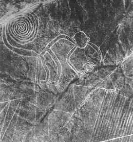 It’s often stated that the lines can only be seen from the air; however, this is a myth. In 1927, Peruvian archaeologist Toribio Mejia Xesspe was the first to study and report the Nazca Lines in detail after coming across them, on foot. A 2007 study that looked at 1,500 drawings in the Palpa region found that “each and every geoglyph” can be spotted from the ground. Although, it is easy for one to conclude that these images were meant for someone to see from above.
The purpose of the lines continues to elude researchers and remains a matter of conjecture. One idea is that they are linked to the heavens with some of the lines representing constellations in the night sky. Another idea is that the lines play a role in pilgrimage, with one walking across them to reach a sacred place such as Cahuachi and its adobe pyramids. Yet another idea is that the lines are connected with water, something vital to life yet hard to get in the desert, and may have played a part in water-based rituals. The Nazca people were successful in using engineering techniques to bring underground water to the surface for irrigation. Some of the theories regarding the purpose of the lines connect them to this need for water.
In the absence of a firm archaeological conclusion a number of fringe theories have popped up, such as the idea that the Nazca people used balloons to observe the lines from up high, something which there is no archaeological evidence for.