Visitors will discover an archaeological treasure at Towosahgy State Historic Site. Located in southern Mississippi County, the site preserves the remains of a once flourishing Indian community. Towosahgy (tah-wah-saw-ge), a borrowed Osage Indian word meaning “Old Town,” was the location of a once-fortified Indian village and ceremonial center between A.D. 1000 and 1400.
Park Hours: 6 a.m. to dusk, daily
Tasks:
1. As you following the cut-grass trail, determine the number of mounds that exists in the historic sites. All but one has a cut-grass path to it.
2. At the temple mound sign, record its elevation. Then follow the path to the top for a panoramic view. Move to the center and take another elevation reading. The difference will be the height and will be used in task number 3.
3. Estimate the length and width of the Temple Mound. Using the information from task number two, the width and the length to calculate the volume of fill that was required to build this mound. Volume = length x width x height.
4. Based on Towosahgy's geographical location, do you think the Mississppi River was closer or farther away than it is today. What evidence did you see as you drove to the site that would support your decision?
5. (Optional, though greatly appreciated) Take a picture of you (and your group) at the historic site.
Historic Site:
Many groups of Indians had lived in this area for 9,000 years prior to the founding of the village, their societies did not reach the highly organized level of the Indians at Towosahgy. The inhabitants of the village were part of the Mississippian cultural tradition, so named as most of these archaeological sites are located near the Mississippi River. Different from their predecessors, the Indians who lived at Towosahgy were town dwellers. There were other, smaller hamlets within a short distance of the main town and the entire area formed a well-developed cultural and political system. The well-constructed dwellings, utensils and other artifacts uncovered at the site indicate the inhabitants led a relatively comfortable lifestyle.
The residents of Towosahgy raised crops of beans, maize, squash and sunflowers in fields outside the walls that surrounded the village. They also lived off wild game, fish, persimmons, wild plums and a variety of nuts. They relied on trade to obtain other necessary items such as salt, paint, chert for tools and ceremonial materials. For transportation, they may have used large dugout canoes. Their houses were constructed by digging a shallow pit, which left the floor of the structure below the surface of the ground. Walls were built of small posts placed in narrow trenches. A central fire hearth and associated packed clay floor mark the original floors of these houses.
Ceramics from the site represent typical pottery found in the Missouri Bootheel region. Sherds from the Woodland occupation are typically grog tempered. The later Mississippian pottery is shell tempered. Mississippian culture pottery was made from locally available clay sources. The clay was then tempered with an additive to keep it from shrinking and cracking in the drying and firing process, usually with ground mussel shells.
Much of their historical record has been buried or destroyed due to flooding, earthquakes, and modern farming methods. Between the movement of the Ohio and Mississippi River, modern farming methods, and the seismic activity, their record is scarce.
Geology:
Geophysiography and Towosahgy
The lowlands of the south-east and part of the Mississippi Alluvial Plain. For the most part well drained, but swampy in its lowest portions. The Mississippi is skirted with lagoons, lakes and morasses. These lowlands are the northernmost extent of the Mississippi embayment. In this area you can find the remnants of Cretaceous rocks (145 to 65 million years ago) in the clay and sand deposited in the Mississippi Embayment.
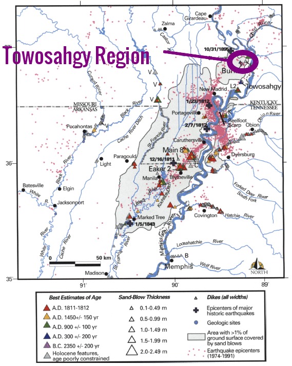
New Madrid Seismic Zone and Towosahgy
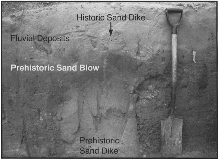
Geoarchaeological excavations have revealed that the village was built on a late Holocene (12,000 to 11,500 years ago) natural levee ridge overlying a sandy point bar of a large abandoned channel of the Missippi River. Excavations also show the site was affected by by sandblows created by a seismic event capable of producing liquefaction and that the site continued to be occupied after earthquake. These sandblows date back to 1250 B.C.
Permission granted by Missouri Department of Natural Resources;