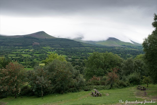
The South Tipperary area is composed mainly of Palaeozoic rocks, however the landscape visible from this point was shaped by events in a period of folding and faulting, and afterwards by the Pleistocene epoch.
Folding and Faulting
Periods of folding causes underlying rocks to fold into great ridges. The underlying rocks were quite soft and eroded quickly. The dust from the eroded rocks compacted over millions of years to form the Old Red Sandstone which the Galtees are composed of.
Pleistocene Epoch
The Pleistocene Epoch (which lasted from about 2,588,000 to 11,700 years ago) saw the earth's most recent repeated periods of glaciation. It is estimated that the earth was 30% covered with ice at the height of the glaciation. The movement of glaciers formed specific geological features, many of which can be seen in the Galtee Mountain Range.
The rounded summits of the mountains were formed during this period when they freeze-thaw action caused them to become worn down. This action caused the scree covering on the summits seen today.
Cirque Glacier
A cirque glacier is formed in a 'cirque' - a bowl-shaped depression on the side of a mountain. The north face of the Galtees harboured a number of cirque glaciers during the Pleistocene epoch. When the ice melted, corrie lakes formed in the hollows. There are five such lakes in the Galtees. One of these lakes is dammed by a rough moraine, through which the Clydagh River runs.
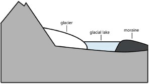
Glacial Moraine
When ice from the glaciers melted, various rocks that had been carried along by the glacier were laid down. Piles of these deposits are called moraines.
To log this earthcache as a find:
Please send me answers to the questions below via the message centre. You do not need to wait for my response, I will contact you if there is any issue.
1. What is the name of the lake that is dammed by a rough moraine, according to the information panel?
2. What period of folding and faulting was the Galtees formed in, according to the information panel?
3. How would you describe the shape of the valley you are standing in: U-Shaped or V-Shaped?
4. OPTIONAL: Please feel free to post any pictures with your log. I'd love to see them!
HAPPY EARTHCACHING!
| I have earned GSA's highest level: |
 |