SK: Vitaj
vo voľnej sérii tradičných kešiek s názvom Elevations QUEST. Vytiahnem Ťa na miesta v krásnej prírode, ktoré sú zaujímavé geograficky, geodeticky alebo len tak... pekným prostredím a/alebo výhľadom.
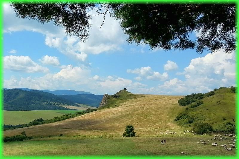
Dnes Ťa pozývam do prekrásnej oblasti bradlového pásma medzi obcami Kyjov a Kamenica. Pre kešku si ideme na kótu 660 m n. m.
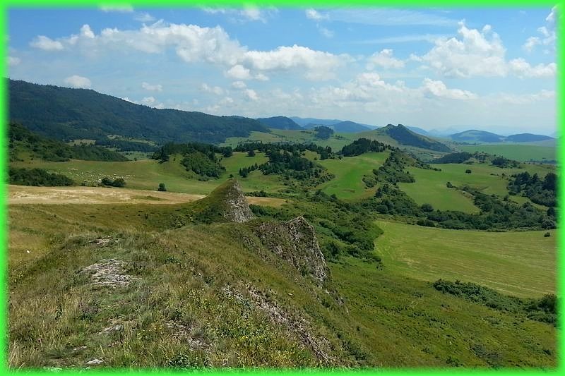
Pieninské bradlové pásmo, skrátene bradlové pásmo (angl. Pieniny klippen belt), je tektonicky a orograficky výrazné pásmo Západných Karpát. Bradlové pásmo je oblúkovitého tvaru a tvorí hranicu medzi Vonkajšími a Centrálnymi Západnými Karpatmi. Utvára úzku (19 až 0,4 km), ale až 600 km dlhú tektonickú jazvu (sutúru) po subdukcii a kolízii časti zemskej kôry, v ktorej sú zachované iba fragmentálne sledy vrstiev a fácií. Vyznačuje sa výskytom pevnejších, hlavne vápencových skalísk - bradiel, vyčnievajúcich zo spravidla menej odolných slienitých a flyšových súvrství tvoriacich bradlový obal.
Na stránke Štátneho geologického ústavu Dionýza Štúra sa dozvieš všetky podrobnosti. Mapku bradlového pásma si pozri napríklad na stránke venovanej minerálom západných Karpát. Prírodnú pamiatku Bradlové pásmo nájdeš zapísanú v Štátnom zozname osobitne chránených častí prírody SR. Viac o okolí si prečítaš aj v listingoch blízkych kešiek, ktorých odlov si tiež môžeš počas svojej návštevy užiť.
A teraz už poď von! Prejdi sa, poseď si v tieni borovice a rozjímaj. Ak budeš mať šťastie, uvidíš aj ovečky. ☺
Nezabúdaj , že bradlá/skaliská, sú prírodnou pamiatkou so štvrtým stupňom ochrany, a teda s obmedzeným prístupom. Keška sa však nachádza na verejne prístupnom mieste.
P.S. Možno už vieš, možno nie, že v štatistikách project-gc sa Ti veľmi pravdepodobne objaví iná nadmorská výška, keďže systém SRTM3, ktorý používajú, je v našich končinách nepresný.
EN: Welcome
to free series of the traditional caches called Elevations QUEST. I am going to bring you to the places in a beautiful nature, which are interesting geographically, geodetically or just as they are... with nice countryside and/or view.
Today I invite you to the beautiful area of the klippen belt, located between Kyjov and Kamenica villages. To pick up the cache we go to the spot height 660 MAMSL.
The Pieniny Klippen Belt is in geology a tectonically and orographically remarkable zone in the Western Carpathians, with a very complex geological structure. It is a narrow (only 0.4 to 19 km) and extremely long (about 600 km) north banded zone of extreme shortening and sub-vertical strike-slip fault zone, resulting from subduction of the Piemont-Liguria Ocean (which is called the Vahic or Pieninic ocean in the Western Carpathians), where only fragments of individual strata and facies are preserved. The Pieniny Klippen Belt is considered one of the main tectonic sutures of the Carpathians and forms the boundary between the Outer (externides a thin-skin thrustbelt) and Central Western Carpathians (internal thick-skin thrustbelt).
More you can read on wikipedia for instance. Complete and thorough info you can find at the State geological institute site. Or look for any info in the listings of surrounding geocaches, finding of which you can enjoy as well at the time of your visit.
So let’s go out! Have a walk, sit to the shade of a pine tree and contemplate. If you are lucky, you can see lambs. ☺
Do not forget, that the rocks/klippen themselves they are protected according to the Law on the Nature protecion. This geocache is however located on the widely publicly accessible place.
P.S. You might know, or not, that within the statistics of the project-gc most probably there will show up different figure concerning the MAMSL, since the system SRTM3, which they use, is quite inaccurate in our area.