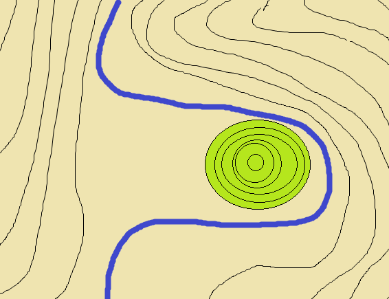
還流丘陵とは?/What is the cut-off spur?
還流丘陵とはかつて回り込むように蛇行して流れていた川が消滅し丘だけが残された地形のことを言います。
Cut-off spur , once the river disappears which has been flowing and meandering to go around the hill. And it refers to the terrain that only hill was left.
還流丘陵の形成/formation of the cut-off spur
平野の中を流れる河川はほとんど勾配がないような所では縦に掘り下げる(つまり海の方向に向けてまっすぐ進む)のではなく、横に広がる運動が基本になり川は蛇行するように流れます。
丘陵を回るように蛇行して流れていた川は丘の上流部の岸を浸食していきやがて下流と結合。
蛇行部には水が流れなくなり丘だけが残ります。これが還流丘陵です。
その形成過程から、還流丘陵は川のそばにあり周りに他の丘が見当たらない/近くにはない つまりその丘だけが不自然に孤立して存在することになります。
なお、流水が消滅した河川跡地は水はけがよく、また山間部の場合は河川跡は数少ない平地となるので田畑や主要道路として利用されることが多いです。
ちなみに蛇行部が消滅せず残った場合は三日月湖と呼ばれる湖になります。
一般的には丘陵が固い岩石で構成されていたことで河川の流れによる侵食から耐え残ったケースが多いですが、柔らかい砂岩でできた丘陵が還流丘陵として残ることもあります。
Rivers flowing through the plains rather than straight forward in the direction of the sea in a place as little gradient, spread to the lateral movement will flow as the river becomes the base for meandering.
The river which has been flowing and meandering as around the hill will continue to erode the banks of the upstream portion of the hill. Time and then combined with the downstream.
Only hill it stops flowing water in the meandering section will remain. This is the cut-off spur.
From its formation process, cut-off spur do not see the other hills around situated near the river or not close. That will be only the hill there was unnaturally isolated.
In addition, the river site that running water has disappeared is drained well, also in the case of mountain areas the river trail is often used as fields and main road since one of the few flat.
By the way, if meander remained without annihilation will be the lake, called the oxbow lake.
In general, hilly remained in many cases bear from erosion due to the flow of the rivers by was composed of hard rock, but there are also hills made of soft sandstone remains as cut-off spur.
還流丘陵のイメージ/cut-off spur's image
TASK
このEarthcacheをFoundするためには、まず下記タスクを実行しQuestionの答えをキャッシュオーナーに送ってください。
For claiming your found, first , Perform each task. And, send to the cache owner your answers for the Questions below.
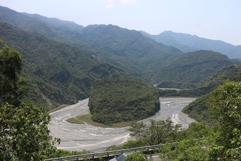
公開座標に指定しているポイントは渡島と呼ばれる丘で、還流丘陵と言われています。
ではここは本当に還流丘陵と言えるのでしょうか。
タスクを実行しつつ、周囲の地形などを観察していきましょう。
Points that are specified in the published coordinates in the hills called Watari-island, is said to cut-off spur.
In What say here is really cut-off spur.
You while performing a task, let's observe, such as the surrounding terrain.
TASK1
Go to WayPoint1
まずは対岸から公開座標の方角を眺めてみましょう。
おそらく小高い丘が見えるかと思います。
その丘を注視しながらTASK2~4の各ポイントの周囲を観察してみましょう。
Let's first look at the direction of the public coordinates from the opposite shore.
Perhaps I think you see a small hill.
Let's observe the surroundings of each point of TASK2 ~ 4 while watching the hill.
TASK2
Go to WayPoint2
この辺りから渡島を背に向けると(つまり北の方向に向くと)目の前はどんな地形でしょうか?
It can be seen by any terrain north of direction towards the Watari-island from this area in the back?
TASK3
Go to WayPoint3
それではこの辺りはどんな地形でしょうか?
So if this area would be any terrain?
TASK4
Go to WayPoint4
この辺りから西~南西方向に向くとどんな地形でしょう?
この場所から大井川は見えるでしょうか?
What kind of terrain and face from the west from this area to the southwest direction?
Can you see Oi-river from this place?
QUESTION
QUESTION1
TASK2~TASK4で通ってきたルートを観察したうえで、かつてこのルートに川(小川などではなく 大井川のように幅広の大きな川)が流れていたであろうということ。そして、渡島は還流丘陵であろうと推測できるでしょうか?
地形的な観点から および 還流丘陵の特徴を含めてあなたの考察を述べてください。
(地学的な観点ではありませんが、現在のこのルートの周囲の利用状況を考察に含めても構いません)
You have to observe the route between TASK4 from TASK2. Once and that would be the river (big wide as Oi-river, not small river) in this route was flowing, what Watari-island can guess that it would be cut-off spur?
Please describe your consideration including from the topographical point of view and the characteristics of the cut-off spur.
(Not a geological, but it does not have to be included in the discussion of the use situation in the vicinity of the current for this route)
QUESTION2
もし渡島が還流丘陵であると推測される場合、川の流れによる浸食を受けずに残ったのは渡島を構成している物質がどのようなものだったからと推測されますか?
還流丘陵でないと推測される場合、この渡島はどのように形成されたか(地盤隆起によるものなのか、土砂の堆積によるものなのか)を推測して答えてください。
If the Watari-island is assumed to be cut-off spur, it was left without the erosion due to the flow of the river is or it is assumed to be because it was what those substances that make up the Dosan?
If it is speculated that the cut-off spur, please this Watari-island answer to guess on how the formation.
QUESTION3
公開座標から西側、大井川を挟んだ先に野守の池という池があります。実はこの野守の池は三日月湖の一種と言われています。
また野守の池の北東には天王山という丘がありますが、この丘も還流丘陵ではないかと言われています。
もし、渡島・天王山が還流丘陵、野守の池が三日月湖でありかつての大井川の名残であると仮定した場合、過去大井川はどのように流れていたか推測して述べてください。
文章で説明するのが大変な場合は絵を描くなりGoogleのマイマップなどで線を引いて説明しても構いません。
West from the public coordinate, there is a pond that previously Nomori-pond across the Oi-River. In fact, this pond is said to be a kind of oxbow lake.
Also in the northeast of the pond there is a hill called Tenno-mountain. This hill has also been said that it is the cut-off spur.
If Watari-island and Tenno-mountain are cut-off spur and the pond is assumed to be remnants of Oi-river of once a crescent lake, please describe to guess or not the flow of how the past Oi-river.
If hard to explain in the text, it may be explained by a line drawn in Google's My Maps or draw a picture.