Sedge Mouth Sand Banks Earth Cache
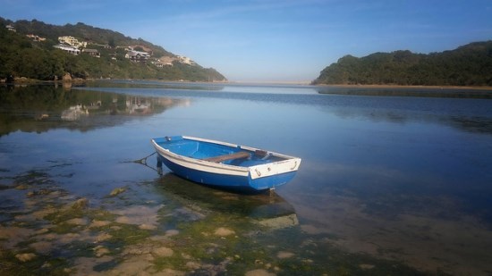
Welcome to the Sedgefield River, one of the most special & beautiful places to us. Every moment shared here is a complete privilege. Trust you are able to soak up and enjoy as much of the tranquillity and beauty you can and that is the most important thing about all our caches in Sedgefield.
The intended value of this particular Earth Cache is to firstly share some the magnificence and stunning tranquillity of the area and spot. Secondly to learn a bit about rivers and how different of their processes and elements work. Thirdly to grasp the importance of preserving the natural flow of an Eco system.
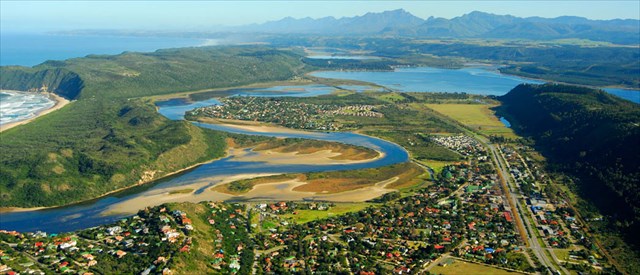
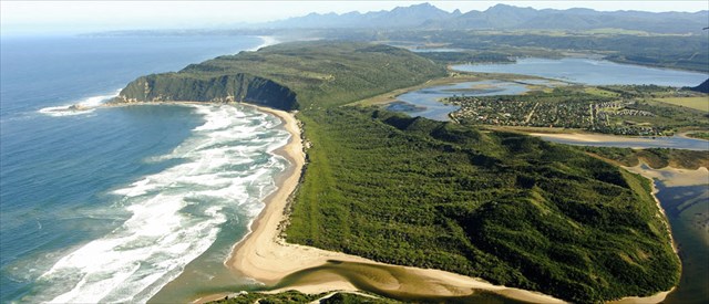
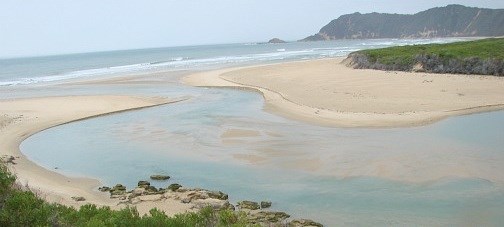
Below are aerial pictures of the Sedgefield Mouth and Upper region of the river:
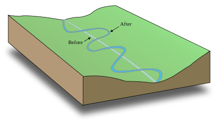
Meanders
A meander, in general, is a bend in a sinuous watercourse or river. Sinuous means having many curves and turns. A meander forms when moving water in a stream erodes the outer banks and widens its valley while the inner part of the river has less energy and deposits the silt. A stream of any volume may assume a meandering course, alternately eroding sediments from the outside of a bend and depositing them on the inside. The result is a winding pattern as the stream meanders back and forth across its down valley axis. When a meander gets cut off from the main stream, an oxbow lake forms.
River channel migration
River channel migration is the geomorphological process that involves the lateral migration of an alluvial river channel across its floodplain. This process is mainly driven by the combination of bank erosion of and point bar deposition over time. When referring to river channel migration, it is typically in reference to meandering streams. In braided streams, channel change is driven by sediment transport.
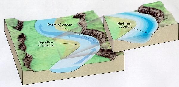
The following diagram is of Meander that forms an oxbow lake generally in a broad flood plain:

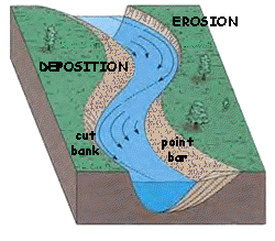
Physical Processes of Bank Erosion
As flow enters the bank of an alluvial river, the centrifugal force created by the bend instigates helicoidal flow, a corkscrew like pattern of flow, which drives the hydraulic action acting on the opposing bank. This is where the primary process in river channel migration of bank erosion occurs. Often the bank is undercut, another result of the helicoidal flow, which leads to the creation of cut banks. Factors that limit the rate of bank erosion include the rate of deposition of the point bar, stream power, and the critical shear stress of the stream bed.
The sediment taken from the bank during the process of bank erosion is deposited on the opposing side of the channel fuelling the process called point bar deposition. The helicoidal flow also plays a role in this process by acting as a cross channel component that moves the sediment to the other side. The processes of point bar deposition and bank erosion are intertwined and in most cases the erosion rate of cut banks is equal to the deposition rate of point bars. In addition, point bars act as topographic obstructions once formed that further drive flow into the opposite bank, creating a positive feedback loop. This leads to the meanders of an alluvial river becoming more well defined over time.
The meander belt is defined by an average meander width measured from outer bank to outer bank instead of from centerline to centerline. If there is a flood plain, it extends beyond the meander belt. The meander is then said to be free.

A meander has a depth pattern as well. The cross-overs are marked by riffles, or shallow beds, while at the apices are pools. In a pool direction of flow is downward, scouring the bed material. The major volume, however, flows more slowly on the inside of the bend where, due to decreased velocity, it deposits sediment.
The line of maximum depth, or channel, is the thalweg or thalweg line. The thalweg is a line connecting the lowest points of successive cross-sections along the course of a valley or river. The thalweg hugs the outer banks and returns to center over the riffles. The meander arc length is the distance along the thalweg over one meander. The river length is the length along the centerline.
Meander formation is a result of natural factors and processes. The waveform configuration of a stream is constantly changing. The cross-current along the floor of the channel is part of the secondary flow and sweeps dense eroded material towards the inside of the bend. The cross-current then rises to the surface near the inside and flows towards the outside, forming the helical flow. The greater the curvature of the bend, and the faster the flow, the stronger is the cross-current and the sweeping.
Due to the conservation of angular momentum the speed on the inside of the bend is faster than on the outside. This secondary flow carries sediment from the outside of the bend to the inside making the river more meandering.
Stochastic theory
"The meander train is assumed to be the result of the stochastic fluctuations of the direction of flow due to the random presence of direction-changing obstacles in the river path." Natural surfaces are rough and erodible to different degrees. The result of all the physical factors acting at random is channels that are not straight, which then progressively become sinuous. Even channels that appear straight have a sinuous thalweg that leads eventually to a sinuous channel.
Equilibrium theory
In the equilibrium theory, meanders decrease the stream gradient until an equilibrium between the erodibility of the terrain and the transport capacity of the stream is reached. A mass of water descending must give up potential energy, which, given the same velocity at the end of the drop as at the beginning, is removed by interaction with the material of the stream bed. The shortest distance; that is, a straight channel, results in the highest energy per unit of length, disrupting the banks more, creating more sediment and aggrading the stream.
Deposits (Point bar)
Point bars are simply an accumulation of deposited alluvium that collects on the inside bank of a meander curve. This accumulation occurs due to the stream's lower velocity in the interior portion of the curve. Sediment will settle more readily at lower velocities. Point bars typically are composed of sediment ranging in size from pebbles to granular sands. Only in still water do silt particles settle. The development of point bars is suggested to depend upon a sufficient suspended load so that finer-grained sediments may be deposited on the inner bank.

Oxbow lakes are created when growing meanders intersect each other and cut off a meander loop, leaving it without an active cutting stream. This process is usually linked to flooding where the river will tend to the path of least resistance. The oxbow, being of much lower energy than the more direct path, collects more and more deposited sediment each season of flooding until it becomes independent from the river. The largest oxbow lakes will be in areas with wider flood plains where the rivers have more room to meander. Over a period of time, these oxbow lakes tend to dry out or fill in with sediments.
Silt is granular material of a size between sand and clay, whose mineral origin is quartz and feldspar. Silt may occur as a soil (often mixed with sand or clay) or as sediment mixed in suspension with water (also known as a suspended load) in a body of water such as a river. It may also exist as soil deposited at the bottom of a water body. Silt has a moderate specific area with a typically non-sticky, plastic feel. Silt usually has a floury feel when dry, and a slippery feel when wet. Silt can be visually observed with a hand lens.
Environmental impacts
Silt is easily transported in water and is fine enough to be carried long distances. Silt and clay contribute to turbidity in water. When silt appears as a pollutant in water the phenomenon is known as siltation.
Dredging is the process of pumping sand from underwater in river beds in order to restore balance. The purpose is to clear the sand pump it to a different spot. The general means of the is sucking through a long tubes like some vacuum cleaners but on a larger scale. This is normally for the reason of helping the water flow or clearing the channels in a river. This technique is also sometimes used to keep replenish the beaches on the side of the river.
Dredging can create disturbance to aquatic ecosystems, often with adverse impacts. Altering the riever path can be both positive and negative. The challenge comes in where there have been manmade obstructions that have caused the balance being disturbed in the first place so the goal is to return the system to balance. It often disturbs the animal life in the sand like the clams and crabs which then also disturbs the birds feeding grounds. So there can be both many positive and negative effects.
This can be both positive and negative for the plant, animal and bird life however above all it is all about maintaining balance in the eco system. This is the main goal of looking after and preserving our river systems.
Sedgefield Mouth Questions
Please take a picture at your favourite spot anywhere near the mouth either side of the Coordinates or along the river and upload in your Log. Please share a picture so everyone can enjoy the collection.
We have kindly provided all the answers for you in the listing. Please return the favour by sharing your answers in your words what your thoughts and understanding is and share some general knowledge through the way you answer and please do not to stress about submitting the answers. The aim of this earth cache is to enjoy and learn.
1 Share about the natural process of the silt from river banks and sandbanks moving along the river. Share this regarding the picking up of silt and the deposition of silt in terms of a meander in a river. Share relating to inside and outside of the meander and what experiences picking up of silt and which experiences deposition of silt. Share about the speed of water in the different parts of the meander both on the inside and outside of the meander.
2 What do you notice about the apparent depths on the different parts inside and outside of the slight meander curve near the Coordinates?
3 What is the human process of moving silt by pumping called and what negative impact do you think this may have on the ecology of the river particularly if not managed properly by overdoing hence why the importance of doing intervention in a balanced manner needs to be done to simulate natural processes as possible?
4 What “indicator” or “man-made obstruction” do you see in the middle of the water near the Coordinates?
5 When a meander forms a loop and eventually gets isolated and cut off from the river it forms a kind of Lake. What is the name given to that kind of Lake?
Thank you for sharing this area and cache with us. We trust that you enjoyed the Earth Cache and your experience here.
Please have a look at our caching series all along the Sedgefield Mouth including the Whereigo caches they all share a closer experience of the river nature and the environment.