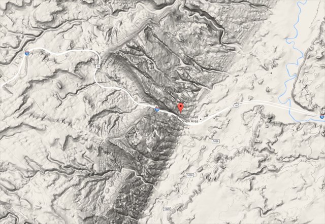
As you face east you see I70 as it cuts through the Spotted Wolf Canyon and climbs to this location. From the ground you see on the valley floor you have climbed a 1000 feet and gone back millions of geological years in time to where you are now.
At this point we need to look at the Law of Superposition or Law of Horizontality. These laws basically state that sedimentary rock formations are created perpendicular to gravity. Given enough time, layers will form perpendicular to gravity with each layer showing a different time or geological time period. These changes in layers help geologist determine the relative age of the rock. As you move downward, the layers get older. This is because the preexisting layers had to have been formed above other preexisting layers.
Now that you’re a bit more familiar with the laws and can now discuss how our earth folds. There are 2 basic types anticline where the earth is squeezed upwards. If we fold up then we must also fold downward as well. This is called a syncline. You can see this in the diagram below.
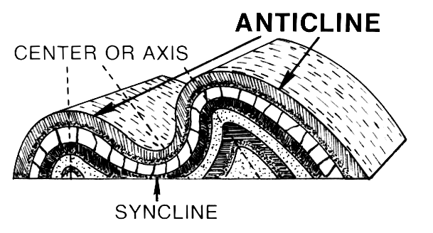
What causes anticlines and synclines to form? Normally, they are formed between tensions along a fault or near a fault. At this location, there has not been any movement in 2.6 million years allowing for the San Rafael Swell to hold is beauty for us to see easily. So let’s now look at different types of folds that can occur. Please refer to the diagram below.

Now, From this overlook, you will have an excellent view to the East and the Spotted Wolf Canyon that cuts through the San Rafael Swell.
Why did the anticlines and synclines form in this area you might ask? This is thanks to the basin and range, a series of thrust faults between the Sierra Nevada's and Rocky Mountains. It's why there are valleys and mountains all in the area.
Now, From this overlook, you will have an excellent view to the East and the Spotted Wolf Canyon that cuts through the San Rafael Swell.
As you look East though where I70 enters to climb up to this location you can see a syncline. The photo below shows this area a bit better where the anticline and synclines are from a top down perspective, as well.
Using some signs at the local location along with all that you have learned above please answer the questions below.
Works Cited
BLM Informational Sign at Site
Wikipedia syncline
Wikipedia anticline
Faults in Utah
To receive credit for this Earthcache, email or message me the answer to the following questions:
1. "San Rafael Reef - Fold" on the first line of your email or message.
2. On the plaque in front of you, there is an old photo of the fold before the interstate was built through. Looking at this photo, can you see an anticline, or syncline? Once you know what you are looking at, where can the oldest layers be found? Where are the youngest? How can you tell? What geologic law says you are correct?
3. Using the reading or other sources can you tell me has the interstate affected the fold, and Why?
4. Optionally, Consider posting a picture of you at the location. Please do not submit photos in which questions can be answered. If I see them I will delete the log.