 This earthcache is located within the Mt. Baker Snoqualmie National Forest and is placed with permission. Note: An earthcache is the magical combination of geocaching and geological discovery. They vary greatly from traditional geocaches in that there is NO PHYSICAL CONTAINER! Once at the Earth Cache site, take in the scenery, the geological marvels or oddities, and read the cache description. You will likely be asked to answer some questions about the site and optionally take a picture. You can email the cache owner or use the Message Center to send answers to the required questions. Please don’t be intimidated about answering the questions. They are not graded and were meant to enrich your visit, open your eyes and provide you with new knowledge and insights about the location. Most importantly have fun!
About the trail:
Table Mountain Trail - difficulty level: moderate.
Length: 2.6 miles Round trip.
Elevation gain: about 725 feet.
Highest Point: 5700 ft.
Season: Late summer, early fall.
A Northwest Forest Pass is required for each vehicle parked at the trailhead.
The trail blasted into the cliffy hillside is an engineering feat. Although airy it is wide. However, if you or anyone in your group are not comfortable in exposed areas you may want to reconsider the hike. Because of the steep and challenging terrain, pets are not allowed and the trail is not recommended for small children. The plateau offers awesome view of Shuksan and Baker as well as the rest of the North Cascades.
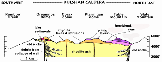
For the general purposes of this earthcache lesson we will be focusing on the setting of Table Mountain. Table Mountain is not a summit in the traditional sense. This summit is composed of ancient lava flows with rolling ups and downs.
The top of Table Mountain is table like because it reflects the original surface of the thick lava flow. The table mountain flow in particular is so thick that geologists think it must have flowed into a constraining canyon in which the molten rock formed a lava lake.
After these valley-filling lava flows solidified,streams and/or glaciers worked on the edges of the flows more efficiently than in the center and eventually left remnants as ridgetops. Erosion produced this marvelous topographical inversion after the lava erupted.
Along this trail you will encounter other geological phenomena starting with columnar joints at WP1. Columnar jointing is a geological structure where sets of intersecting closely spaced fractures, referred to as joints, result in the formation of a regular array of polygonal prisms, or columns. Columnar jointing occurs in many types of volcanic rocks and forms as the rock cools and contracts. They can be parallel and straight, or curvy and vary in diameter.

Also of geological importance are the erratics located at the summit of the mountain and at the posted coordinates. An erratic is a piece of rock that has been eroded and transported by a glacier to a different area; it is left behind when the ice melts. Glacial erratics give us information about the direction of ice movement and distances of transport.
The erratics here are Chilliwack Group breccia, which underlies the high peak of Mount Herman rising just across the deep gulf of Bagley Lakes to the north. Here is an interesting juxtaposition, for although both Table Mountain and Chilliwack breccia rocks are andesitic, they have very different origins. Table Mountain lavas are young deriving from a vent to the west on Ptarmigan Ridge; the Chilliwack rocks are ancient and submarine, the remnant of a Permian island chain of volcanoes that shed eruptive debris into an ancient ocean. These rocks were later accreted to the margin of North America during subduction.
EDUCATIONAL LOGGING REQUIREMENTS
In order to substantiate your visit and comply with the educational requirement for Earth Caches you have to submit your answers to the following questions to the cache developers via their profile:
For purposes of logging this cache you must answer the following four questions.
1) At WP1 describe the columnar joints. Are they straight or wavy? What is the approximate diameter of most of them?
2) At the posted coordinates how many erratics are located here?
3) Since erratics are clearly different from the surroundings that they sit on please describe the difference between the two rock types.
4) Also of significance at this site is that it demonstrates the depth and direction of the glacial ice of the last glaciation (Vashon). By looking across the valley and at the enclosed diagram at what elevation in feet and in which direction did the glacial ice move?
|
Resources:
https://www.wta.org/go-hiking/hikes/table-mountain
https://nwgeology.wordpress.com
https://en.wikipedia.org/wiki/Columnar_jointing
https://nsidc.org/cryosphere/glaciers/gallery/erratics.html