
At the listed coordinates you will find observation point and just outside this observation point you can find some nice examples of karst geomorphology.
Karst Landscape
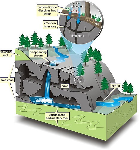
The term “karst” applies to a distinctive type of landscape that develops from the dissolving action of water on soluble bedrock - primarily limestone and marble but also dolostone, gypsum and halite.
Karst landscapes are characterized by fluted and pitted rock surfaces, shafts, sinkholes, sinking streams, springs, subsurface drainage systems, and caves. The unique features and three-dimensional nature of karst landscapes are the result of a complex interplay between geology, climate, topography, hydrology, and biological factors over long time scales. Globally, examples of karst topography can be found at all latitudes and at all elevations, with rock types potentially containing karst covering approximately 20% of the Earth’s land surface.
Karst Landscape
 Source: northpennines.org.uk
The three-dimensional nature of a karst landscape can be broken down into three parts: (1) exokarst, (2) epikarst, and (3) endokarst.
Exokarst describes all features found on the surface of the karst landscape, ranging from small-scale to large-scale features (e.g., from karren to sinksinkholes to poljes). Epikarst is the zone of solutionally enlarged openings or fractures that extends from the surface (the exokarst) down as much as 10–30 m below the surface to the underlying endokarst. The endokarst describes all deeper components of the underground karst landscape, including the smallest cavities, cave speleothems, cave sediments, and cave passages. The epikarst zone plays a critical role in the karst system, allowing water, air, and other materials (sediment, organic debris, and nutrients) to be readily transferred from the surface to the subsurface.
Karst Chemistry
The karst is developed when acidic water breaks down the surface of bedrock (for example limestone or dolostone bedrock). As time goes on, the bedrock continues to break down and its cracks tend to get bigger and bigger. The fractures in bedrock will become wider, and eventually, a drainage system of some sort may start to form underneath. In situations when underground drainage system forms, it actually speed up the development of karst because more water will be able to flow through the region.
Karst Chemistry
 Source: sierraclub.bc.ca
The carbonic acid that causes the formation of karst is formed when rain passes through the atmosphere picking up carbon dioxide (CO2), which dissolves in the water. Additionally, when the rain reaches the ground and passes through the soil it can pick up much more CO2 from the soil. Then a weak carbonic acid solution is formed and it dissolves calcium carbonate in rocks.
Logging Tasks
To log this EarthCache answer the following questions:
1. Observe the rock formation near the observation point. Describe its color and texture.
2. Explain in your own words how this karst formation has been formed.
3. Does it belong to exokarst, epikarst or endokarst? Why?
Send your answers through my profile at geocaching.com (through e-mail or message center) and NOT in a log. You don't have to wait for me to approve your answers. Once you send your answers feel free to log this EarthCache as found. If there are problems with your answers, I will contact you.
Sources
1. Alecia M. Spooner, Geology for Dummies, Hoboken: Wiley Publishing, Inc., 2011.
2. Tim Stokes, Paul Griffiths, Carol Ramsey, "Karst Geomorphology, Hydrology, and Management", Compendium of Forest Hydrology and Geomorphology in British Columbia, pp. 373-400, 2010.
3. Wikipedia.org

Na izlistanim koordinatama pronaći ćete promatračnicu, a odmah izvan promatračnice možete zapaziti lijepe primjerke krške geomorfologije.
Krški krajolik
Pojam "krš" se odnosi na zasebnu vrstu krajolika koji nastaje djelovanjem vode na topivim stijenama - u prvom redu vapnenca i mramora, ali i dolomita, gipsa i halita.
Krški krajolik je karakteriziran naboranim i udubljenim kamenim površinama, vrtačama, ponornicama, izvorima, podzemnim tokovima i špiljama. Jedinstvena obilježja i trodimenzionalna priroda krškog krajolika predstavlja rezultat kompleksnog međuodnosa geologije, klime, topografije, hidrologije i bioloških faktora tijekom dugih vremenskih perioda. Globalno, primjeri krške topografije se mogu naći na svim geografskim širinama i na svim nadmorskim visinama. Vrste stijena koje potencijalno mogu sadržavati krš pokrivaju 20% zemljine kopnene površine.
Krški krajolik
Izvor: northpennines.org.uk
Trodimenzionalna priroda krškog krajolika se može podijeliti u tri dijela: (1) egzokrš, (2) epikrš i (3) endokrš.
Egzokrš obuhvaća krške pojave koje se nalaze na površini krškog krajolika, u rasponu od malih pojava do velikih (npr. od škrapa do vrtača do polja). Epikrš je zona otvora i pukotina koje se šire od površine (od egzokrša) u dubinu i do 10-30 metara ispod površine prema endokršu. Endokrš obuhvaća sve dublje komponente podzemnog krškog krajolika, uključujući najmanje otvore, špiljski ukrasi, špiljski sedimenti i špiljski prolazi. Zona epikrša ima ključnu ulogu u krškom sustavu, jer omogućava redoviti protok vode, zraka i ostalih materijala (sedimenata, organskih ostataka i hranjivih tvari) sa površine u podzemlje.
Kemija krša
Krš nastaje pod utjecajem kiselosti vode, pri čemu takva voda otapa površinu stijene (na primjer, vapnenac ili dolomit). S protokom vremena, proces otapljanja stijene se nastavlja, te pukotine u stijeni postaju sve veće. Pukotine u stijeni postaju sve šire, te konačno može doći do razvijanja sustava podzemnog toka vode. U slučajevima kada dođe do razvoja podzemnog toka vode, dolazi i do ubrzavanja nastajanja krša zato što veća količina vode može protjecati kroz područje.
Kemija krša
Izvor: sierraclub.bc.ca
Ugljična kiselina koja uzrokuje stvaranje krša nastaje pri prolasku kiše kroz atmosferu, pri čemu se ugljični dioksid (CO2) otapa u vodi. Dodatno, kada kiša dođe do površine i pri prolasku kiše kroz tlo, u vodi se mogu otopiti čak i veće količine CO2. Tada dolazi do formiranja slabe otopine ugljične kiseline koja topi kalcijev karbonat iz stijena te dolazi do formiranja krša.
Zadaci za logiranje
Kako biste logirali ovaj EarthCache odgovorite na sljedeća pitanja:
1. Promotrite stijenu koja se nalazi u blizini promatračnice. Opišite njezinu boju i teksturu.
2. Objasnite svojim vlastitim riječima kako je nastala ova krška formacija.
3. Pripada li ova stijena egzokršu, epikršu ili endokršu? Zašto?
Odgovore pošaljite preko mog profila na geocaching.com, a NE u Vašem logu! Ne morate čekati na moje potvrdjivanje Vaših odgovora. Jednom kada pošaljete Vaše odgovore slobodno logirajte pronalazak ovog EarthCachea. Ako Vaši odgovori budu pogrešni ja ću kontaktirati Vas.
Izvori
1. Alecia M. Spooner, Geology for Dummies, Hoboken: Wiley Publishing, Inc., 2011.
2. Tim Stokes, Paul Griffiths, Carol Ramsey, "Karst Geomorphology, Hydrology, and Management", Compendium of Forest Hydrology and Geomorphology in British Columbia, pp. 373-400, 2010.
3. Wikipedia.org