ITALIANO
1. Il fiume Adige - Caratteristiche generali
L'Adige (Etsch in tedesco e in dialetto sudtirolese, Adesc in ladino, Ades in trentino, Àdexe in veneto, Athesis in latino, Atheses, Άθεσης in lingua greca antica) è un fiume dell'Italia nordorientale.
Nasce presso il passo Resia (Reschenpass) nell'Alta Val Venosta (Obervinschgau) in Alto Adige e sfocia nel mare Adriatico presso i comuni di Chioggia e Rosolina nelle rispettive frazioni di Sant'Anna di Chioggia e di Rosolina Mare. È per lunghezza il secondo fiume italiano dopo il Po, il terzo per ampiezza di bacino dopo Po e Tevere e il quarto per volume d'acque dopo Po, Ticino e Tevere con 235 m³/s di portata media annua presso la foce.
Attraversa le città di Trento, Verona, Legnago, Cavarzere e lambisce Merano, Bolzano, Rovereto e Rovigo. Passa per le regioni del Trentino-Alto Adige e del Veneto. La valle in cui scorre assume vari nomi:
-
Val Venosta tra la sorgente e Merano
-
Valle dell'Adige tra Merano e Trento
-
Vallagarina tra Trento e Verona
-
Val Padana tra Verona e la foce.
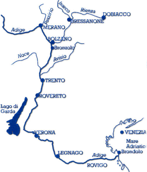
Fig. 1 - Il corso del fiume Adige dalla sorgente alla foce
Complessivamente il suo bacino idrografico è di 12.000 km² (che lo rendono il secondo in Italia per ampiezza dopo il Po): di questi ben 7.200 sono in Provincia di Bolzano, nel cui territorio scorre per 140 km, mentre i restanti sono suddivisi tra le provincie di Trento, di Verona, di Padova, di Rovigo e di Venezia.
Domande:
- Quanto è lungo il fiume Adige? Quali sono i suoi quattro affluenti in territorio trentino (TN)?
- Il fiume sorge a 1550 m.s.l. A che altitudine vi trovate ora?
- Descrivi l'andamento del fiume (la corrente è lenta/veloce?), il colore dell'acqua (blu, azzurro, caffelatte, etc...) e la sua portata (è in una fase di piena/magra?)
- Spostandoti dalle coordinate postate verso il WP1 stima (o misura) la larghezza del fiume
- Alle coordinate del WP1 trova nel testo del pannello informativo il lato della città che è stata protetto nel corso del tempo dall'ansa dell'Adige alla tua destra
- Facoltativo (ma fortemente consigliato): allega nel log una foto di te con il GPS vicino al fiume.
Istruzioni per il log di questa cache:
- Inviate al mio profilo Geocaching le vostre risposte tramite la chat o email, SENZA scriverle nel log.
- Dopo avermi contattato potete subito fare il log aggiungendo, se volete, anche qualche foto del posto.
- Se qualche risposta è sbagliata, vi contatterò per cercare di correggerla.
ENGLISH
1. Adige river - General characteristics
The Adige river (Etsch in german and in South Tyrolean dialect, Adesc in ladin language, Ades in Trentino dialect, Àdexe in Venetian dialect, Athesis in ancient latin language, Atheses, Άθεσης in ancient greek language) is a river of northeastern Italy.
Its source is located at Passo Resia (Reschenpass) in the Upper Vinschgau (Obervinschgau), South Tyrol, and flows into the Adriatic sea at the municipalities of Chioggia and Rosolina in their villages of Sant'Anna di Chioggia and Rosolina Mare. It is the second longest Italian river after the river Po, the third for the basin amplitude after the Po and the Tiber and has the fourth volume of water after the Po, Ticino and the Tiber with 235 m³/s annual average flow at the mouth.
The main cities the Adige river flows through are Trento, Verona, Legnago, Cavarzere and it laps Meran, Bolzano, Rovereto and Rovigo. It passes through the regions of Trentino-Alto Adige and Veneto. The valley in which this river flows assumes various names:
-
Val Venosta between the source and Meran
-
Valle dell'Adige between Meran and Trento
-
Vallagarina between Trento and Verona
-
Val Padana between Verona and the mouth.
Fig. 1 - The course from the source to the mouth.
Overall, its catchment area is about 12000 km². 7200 of there km² are located in the province of Bolzano, in the territory of which runs for 140 km, while the rest are divided between the provinces of Trento, Verona, Padua, Rovigo and Venice.
Questions:
- How long is the Adige river? Which are its four tributaries in the Province of Trento (TN)?
- The source of the river is at 1550 m a.s.l. At which altitude are you in this place?
- Describe the flowing of the river (is the river current slow/fast?), the color of the water (dark/light blue, dirty, etc...) and the flow rate (is there at the moment any flood/low water?)
- While moving from the posted coordinates to the WP1 make an estimate (or even measure) the width of the river.
- At the coordinates of WP1 find in the text of the informative panel the side of the city of Trento which has been protected over time by the bend of the river you see at your right .
- Optional (but strongly suggested): attach in the log a picture of you and your GPS near the river.
How to to log this cache:
- Send to my Geocaching profile your answers by chat or mail, NOT on the log
- After contacting me you can log the cache (you can also upload some pictures, but NOT of the panel!)
- If any answer is wrong, I’ll contact you to correct it
