The Baden Hills ESPA consists of a series of four prominent sandy hills which are some of the largest kames in Southern Ontario. Due to their height, the hills are quite scenic and impressive. They afford extensive views from their summits, especially of the glaciated aspects of the surrounding landscape. Gibney Regional Forest is found on one of these hills on the east side of Sandhills Road. There are two forest stands and a large field area found in Gibney Regional Forest. The field area has been used to establish a prairie grass nursery and as an experimental agroforestry site. In addition, a neighbouring farmer has been cropping those parts of the field not actively used by the Region. The forest stands are found growing on the slopes of a large kame. The northern part of the kame comprises primarily upland hardwood species while the remainder is conifer plantation. The steep topography in the central areas tends to exclude casual human access.
General Management Goals - The conifer stand is mature and the White Pine and White Spruce require thinning. Over time, the plantation will be allowed to revert to a mixed hardwood condition as crop trees are removed with thinning and harvest activities. The field area requires a well developed schedule of activities designed to monitor and encourage the development of the prairie grass nursery.
Access to Gibney is from Sand Hills Road. There is no formal parking area, and visitors must park on the shoulder of Sand Hills Road. Access up the west facing slope of the kame is unmarked and requires some effort. The trail that winds through the forest stands is largely overgrown and can be difficult to find.
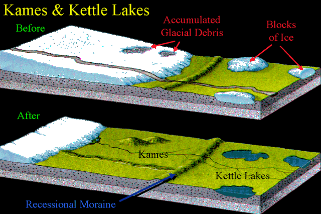
A kame is a geomorphological feature, an irregularly shaped hill or mound composed of sand, gravel and till that accumulates in a depression on a retreating glacier, and is then deposited on the land surface with further melting of the glacier. Kames are often associated with kettles, and this is referred to as kame and kettle topography.
According to White, "kames were formed by meltwater which deposited more or less washed material at irregular places in and along melting ice. At places the material is very well washed and stratified; at others it is more poorly washed, with inclusions of till masses that fell from ice but were covered before they were completely washed. Kame gravels thus tend to be variable and range from fine to coarse grained and even to cobbly and boulder."[1]
With the melting of the glacier, streams carry sediment to glacial lakes, building kame deltas on top of the ice. However, with the continuous melting of the glacier, the kame delta eventually collapses on to the land surface, furthering the "kame and kettle" topography.
Kame terraces are frequently found along the side of a glacial valley and are stratified deposits of meltwater streams flowing between the ice and the adjacent valley side.[1] These kame terraces tend to look like long flat benches, with a lot of pits on the surface made by kettles. They tend to slope downvalley with gradients similar to the glacier surface along which they formed, and can sometimes be found paired on opposite sides of a valley.
Kames are sometimes compared to drumlins, but their formation is distinctively different. A drumlin is not originally shaped by meltwater, but by the ice itself and has a quite regular shape. It occurs in fine-grained material, such as clay or shale, not in sands and gravels. And drumlins usually have concentric layers of material, as the ice successively plasters new layers in its movement.
Kames are not normally located in proximity to one another, however in Edmonton, Alberta, numerous kames are found nearby, forming the Prosser Archaeological Site.
To receive credit for this earthcache, email or send a message with the following answers:
1 - estimate the height of this hill. Take an elevation measurement at the top of the hill. N 43° 24.098 W 080° 38.518. Take an elevation at N43° 24.214' W80° 38.828'. The difference should give you an approximate height.
2 - How many kames are in this moraine?
3 - What are the names of two nearby kettle lakes (maps will help you here).
4 - Which direction did the ice sheet move according to the hills?
5 - Because of their elevation, what has one of the hills been used for?
References: https://en.wikipedia.org/wiki/Kame
http://www.regionofwaterloo.ca/en/discoveringTheRegion/resources/2014_Wilmot_Tour_3_Access.pdf https://en.wikipedia.org/wiki/Baden_Hill
