[ITA] LA PIANA DI FONDOTOCE
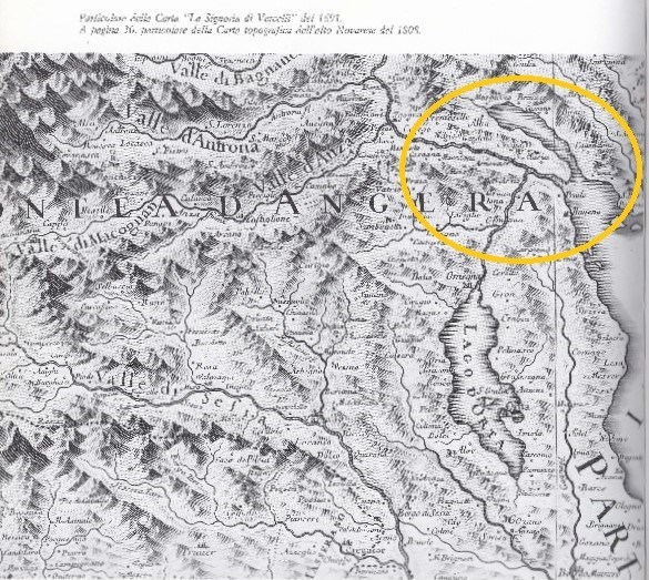
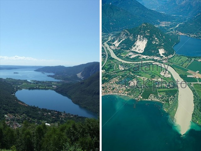
Percorrendo il paese di Fondotoce si può subito notare che le abitazioni più vecchie sono costruite ai piedi della collina, mentre nella zona pianeggiante vi sono le case più recenti: ciò suggerisce immediatamente che la piana sia un territorio di più recente formazione geologica, occupata in un passato non troppo lontano, dalle acque del lago Maggiore. Un tempo dunque il golfo Borromeo era molto più ampio di adesso e mostrava due insenature separate dal Montorfano, una rappresentata dall’attuale lago di Mergozzo e l’altra che giungeva fin quasi a Gravellona (Foto 1). Sulla base di numerose informazioni si può ipotizzare che la formazione della piana di Fondotoce e la conseguente separazione del lago di Mergozzo dal lago Maggiore , iniziata nel XIII secolo, sia andata completandosi tra il XIV e il XV secolo: tutto questo ad opera del continuo deposito di materiale detritico alluvionale trasportato dal fiume Toce, “la Toce”, e dal fiume Strona, che un tempo sfociavano separatamente nel lago Maggiore. Al giorno d’oggi il lago di Mergozzo è ancora in collegamento con il lago Maggiore tramite un canale artificiale e la piana è ora occupata da prati, campi, pioppeti, aziende florovivaistiche e campeggi (Foto 2).
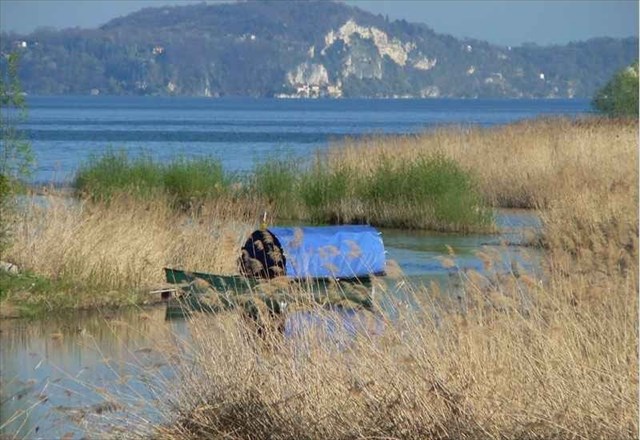
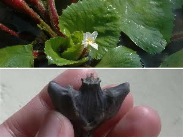
A Fondotoce le sponde del lago sono basse e sabbiose, a conferma dell’origine alluvionale della piana: non a caso qui è cresciuto il canneto, che è il più grande rimasto nel nostro lago. Questa zona è stata eletta a Riserva Naturale Speciale già dal 1990 e rappresenta un tipico esempio di “zona umida”, zona cioè di transizione tra terra e acqua a prevalente vegetazione spontanea, costituita da canneti di cannuccia di palude (Phragmites australis) (Foto 3). La zona presenta un alto grado di biodiversità ed offre un ecosistema ideale per la riproduzione di numerosi pesci di lago (carpa, luccio, tinca, ecc.) e per la nidificazione e lo svernamento di un centinaio di specie di volatili. In essa trovano inoltre rifugio tantissimi animali quali rettili, anfibi, mammiferi e insetti. Tra le specie vegetali acquatiche è presente una castagna d'acqua che è possibile incontrare solo in questa zona (Trapa natans varietà verbanensis) (Foto 4). L'importanza del canneto è dovuta anche alla sua fondamentale funzione di "filtro verde": le canne assorbono infatti numerose sostanze inquinanti contribuendo alla depurazione delle acque.
Domande:
- Qual è l’origine della piana di Fondotoce?
- Quali fiumi hanno contribuito alla sua formazione?
- Qual è stata la principale conseguenza della formazione della piana di Fondotoce?
- Con quale classificazione europea è stata riconosciuta la Riserva?
- Quale albero fa ombra alla torretta di avvistamento alle coordinate del listing?
- Mi farebbe piacere una vostra foto con il canneto.
Per favore inviate le risposte sui messaggi attraverso il nostro profilo; generalmente rispondiamo velocemente dunque attendete la nostra autorizzazione al log.
[ENG] FONDOTOCE FLOOD PLAIN
Walking through the village of Fondotoce you can immediately notice that the older buildings are located at the foot of the hill, whereas the more recent ones can be found in the plain area: this straightaway suggests that the plain is a territory of more recent geological formation which was once not long ago flooded by the waters of Lake Maggiore. Formerly the Borromean Gulf was in fact far wider than it is now and it also featured two inlets which were separated by Montorfano: one is represented by the present-day Lake of Mergozzo and the other almost reached out to Gravellona (Image 1). On the basis of a number of sources it can be assumed that the formation of the Fondotoce plain and the subsequent detachment of the Lake of Mergozzo from Lake Maggiore (begun during the XIIIth century) eventually reached completion between the XIVth and XVth centuries. This whole process was carried out by the continuous deposit of alluvial detrital material washed out by the river Toce, “la Toce”, and by the river Strona which once both flowed into Lake Maggiore. Nowadays the lake of Mergozzo is still linked to Lake Maggiore via an artificial canal and on the plain there are now meadows, fields, poplar groves, floricultural businesses and campsites (Image 2).
In Fondotoce the lake shores are low and sandy thus confirming the alluvial origin of the plain: it is in fact not by chance that reeds have grown here which constitute the largest cane thicket of our lake. This area has been designated Special Nature Reserve already in 1990 and it represents a classic example of “wet land” thus indicating a transition zone between earth and water where spontaneous vegetation such as groves of common reed (Phragmites australis) can be found (Image 3). The Reserve presents high levels of biodiversity and it offers an ideal ecosystem for the reproduction of many freshwater fish (carp, pike, tench, etc.) and for the nesting and overwintering of about a hundred species of birds. There, plenty of animals such as reptiles, amphibians, mammals and insects also find shelter. Among the aquatic plant species there is a particular variety of water chestnut which can only be found in this area (Trapa natans verbanensis) (Image 4). The importance of this cane thicket is also due to its essential function as “green filter”: in fact, the reeds absorb many pollutants thus contributing to water depuration.
Questions:
- What is the origin of the Fondotoce plain?
- Which rivers contributed to its formation?
- What was the main consequence of the formation of the Fondotoce plain?
- Which European recognition has the Reserve been acknowledged with?
- Which tree does shade the watchtower at the listed coordinates?
- I would like to see a picture of you with the reeds.
Please send all the answers via the ‘Send message’ option on our profiles; we usually reply quite quickly, so wait for us to give you the green light to log.
FOTO/IMAGE 1
FOTO/IMAGE 2
FOTO/IMAGE 3
FOTO/IMAGE 4