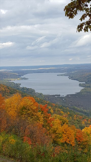
This cache will bring you to one of my favorite places, a spectacular view of Honeoye Lake from Harriet Hollister Spencer Memorial Recreation Area. This is an earthcache, and nothing physical is placed in the park. This earthcache will teach you some information on glacial formations. To log this geocache, you will need to email me answers to questions found below.
There are two benches at this location where you can sit and enjoy the view. This view really needs to be seen in all four seasons. During the winter months, this will be a .48 hike to the overlook. In summer months, the gate will be open and you can drive right up to the overlook. Snowshoes, cross-country skis and snowmobiles are allowed in designated areas and the hike to the overlook is on maintained trails.
This earthcache was approved by the New York State Office of Parks, Recreation and Historic Preservation. New York State Park Permit 17-001.
Here is some information on the glacial formation of the Finger Lakes, taken from this article written by Laurel Wemett regarding geological information of the Finger Lakes. http://www.lifeinthefingerlakes.com/geological-history-and-glacial-formation-of-the-finger-lakes/
For the Finger Lakes “west” (all the lakes west of Seneca: Keuka, Canandaigua, Honeoye, Canadice, Hemlock and Conesus), the northward drainage is a reversal of the preglacial drainage direction. In the Finger Lakes “east”: Seneca, Cayuga, Owasco, Skaneateles, and Otisco, the apparent preglacial drainage was northward as it is now, although modified by glaciation. The basins of the western Finger Lakes are smaller, shorter, and shallower than those of the eastern lakes, perhaps because the northern ends of the western Finger Lakes were higher.
Many unique features of the natural scenery of the Finger Lakes area owe their existence to the glacial invasion of the Pleistocene Epoch. Some of New York’s most spectacular gorges and waterfalls are secondary products of the Ice Age. The tributary streams are the sites of the many famous glens. East-west tributaries, lying athwart or across the direction of the ice flows, were excavated to lesser depths. As a result they were left hanging far above the main valleys and now cascade into them through a series of scenically spectacular waterfalls.
One of the geological features caused by glaciers are hanging valleys. A hanging valley is defined as a side valley that enters a main valley at an elevation high above the main valley floor. Hanging valleys are typically formed when the main valley has been widened and deepened by glacial erosion, leaving the side valley cut off abruptly from the main valley below. The steep drop from the hanging valley to the main valley floor usually creates cascading waterfalls.
To log this earthcache, you will need to email me with the answers to the following questions: 1. What type of drainage does Honeoye Lake have? 2. Why are the basins of the Western Finger Lakes smaller, shorter, and shallower than those of the Eastern Finger Lakes? 3. Describe the effect of the glacial invasion of the Pleistocene Epoch. 4. Take a look around at the surroundings. Do you see any evidence of a hanging valley? If yes, what is the evidence? If no, what would you expect to be seeing at the site of a hanging valley? 5.. Optional- Post a picture of the view of Honeoye Lake in your log. Will be nice to see the view in logs from different days of the year.
| I am a proud |
 |