 SECESSION!
PUZZLE UPDATED ON MARCH 13, 2017 TO KEEP GOOD RELATIONS WITH LANDOWNER
In 1967 the official Wisconsin highway map, published by the State Highway Commission, omitted Winneconne a little village straddling the Wolf River.
A Secret Committee was formed to look at what the village should do next. The story spread all over the United States and to the rest of the world about the forgotten village. A nationwide contest was run to get ideas on how to get Winneconne back on the map.
Plans were made for Winneconne to secede from the State of Wisconsin on July 21, 1967.
Governor Warren P. Knowles, realizing that the village was serious, sent an urgent telegram asking the village to reconsider this drastic action. Negotiations on Sunday led to a successful solution.
• The governor agreed to have signs placed on highways directing motorists to the community.
• And, he assured that he would review the 1968 maps before going to print.
• The village would be restored to its former position in the state.
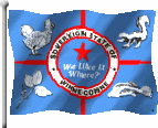
The Sovereign State of Winneconne was born and died on July 21, 1967. It has been reincarnated annually ever since as the Sovereign State Days weekend celebration.
You will find this cache at N44 33.3AB W90 00.2CD
A = True = 4 False =7 Winneconne is located near the Fox River.
B = True = 2 False = 0 Governor Warren P. Knowles, sent an email asking the village to reconsider their drastic action.
C = True = 9 False = 2 Plans were made for Winneconne to secede from the State of Wisconsin on July 21, 1967.
D = True = 5 False =8 The Sovereign State of Winneconne was officially recognized in 1968.