SIR JOHN DOYLE
Sir John Doyle was an Irishman who served as lieutenant-governor of Guernsey between 1803 and 1815 and for part of this time was also the MP for the Isle of Wight, about 100 miles (160km) away!!
According to one source this is the 3rd column on the small hill that was built to commemorate his memory but I can only find reference to two.
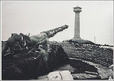
The original monument was built of granite on top of a small hill in 1825 with the simple inscription: "Doyle - Gratitude".
It was 101 feet (30 m) in height and had a staircase inside so people could climb to a viewpoint 450 feet above sea level (after first getting the key from the “Sign of the Steamer”, a small public house nearby). Apparently the top was 14 ft square and could accommodate 30-40 persons.
Alas the monument was demolished by German engineers in 1944 as they had built the "Batterie Strassburg" close to the site and found the column blocked the 360 degree angle of fire.
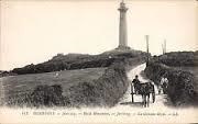
The present smaller monument, the subject of this earth cache, was built in the same location at a cost of £1,400, and was completed in 1953.
GUERNSEY UNITED
Why was Sir John so well-liked by the locals?
Basically he got them better island infrastructure and saved them money, whilst at the same time ensuring they were better protected from invasion by the French
Up to the 18th century a channel divided Guernsey into 2 parts, making the NE corner around Vale a separate island. The Duke of Richmond’s map of 1787 clearly shows the north of the island (Clos du Valle) separated off from the rest of the island by a channel of water (Braye du Valle) some parts of which might have been fordable at low tide. However, most crossings had to be done by boat, although at 3 narrow spots bridges had been built :- Le Grand Pont at St Sampson’s, Le Pont Allaire at Vale church & Le Pont Colliche at Saltpans. The Duke’s map revealed how very vulnerable the low-lying north of the island was to attack by Napoleon but the islanders were put off from draining the land because of the cost, since the land was owned by heirs of the very first owner, Henry de Vic, who received money from the Crown for every acre of land that was reclaimed.
The early part of the 19th century was a time when Great Britain and the Channel Islands felt very vulnerable to attack by Napoleon and the French troops and the low lying north of the island felt very vulnerable. In 1805 Doyle cleverly persuaded the British Government to buy land in the north for £1,500 (around 1.5 million pounds today) and in addition the owners of salt pans on the foreshore received £ 1,750 (that is approximately 1.9 million today) compensation.
His plan was to make the bridge at St Sampson watertight, so blocking off the eastern end of the channel, and create a breakwater at the western end of brick and rubble. Quarry ships passing through Grand Havre bay could then add ballast to reinforce this western wall and, with sluice gates added to each end, tidal inundations and flooding could be drained. By 1808 the land had drained sufficiently for 300 acres to be useable and the only part not drained (now known as Vale pond) was well stocked with fish.
Doyle's real stroke of genius, however, was then to sell off the 300 reclaimed acres to 6 different individuals for a total of £5,000 (5.4 million today) giving a tidy profit which Doyle, philanthropically handed to the States of Guernsey as a gift to be used for the building of new military roads.
Thus not only was valuable land gained, but Guernsey got much better transport links and fortifications with a significantly reduced financial outlay.
GUERNSEY GEOLOGY
Some of the rocks on Guernsey are very ancient. The southern part of the island is largely composed of Precambrian gneiss. This has a composition similar to granite and appears to have been metamorphosed from this rock around 2,061 million years ago according to U-Pb dating on zircon grains.
The centre and the west of the island are composed of quartz diorite (another type of gneiss) which is around one third of the age.
In the north there are large areas of granite formed in Cambrian times approximately 570 million years ago. These red-brown granites are named after Cobo Bay on the mid west coast.
Dolerite dykes are common on the island which only became separated from Europe around 7000 years ago (new stone age)
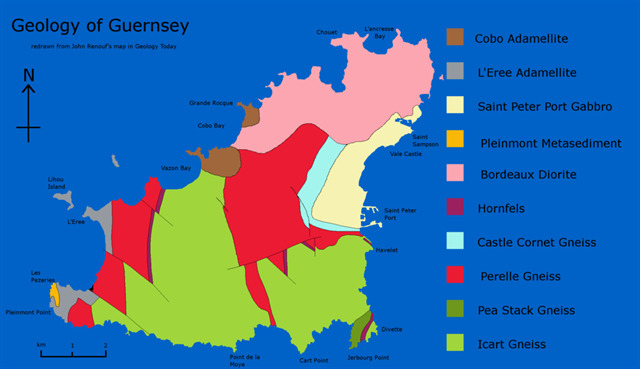
Gneiss is a foliated metamorphic rock identified by its bands and lenses of varying composition. Sometimes other bands contain granular minerals with an interlocking texture or contain platy or elongate minerals with evidence of preferred orientation. It is this banded appearance and texture - rather than composition - that define a gneiss.
Diorites are a group of coarse-grained igneous rocks with a composition between that of granite and basalt. Diorite usually occurs as large intrusions, dikes, and sills within continental crust. Diorite is usually composed of sodium-rich plagioclase with lesser amounts of hornblende and biotite and it usually contains little if any quartz. This makes diorite a coarse-grained rock with a contrasting mix of black and white mineral grains. Students often use this "salt and pepper" appearance as a clue to the identification of diorite.
Granite is a light-colored igneous rock with grains large enough to be visible with the unaided eye. It forms from the slow crystallization of magma below Earth's surface. Granite is composed mainly of quartz and feldspar with minor amounts of mica, amphiboles, and other minerals. This mineral composition usually gives granite a red, pink, gray, or white color with dark mineral grains visible throughout the rock.
Basalt iis a dark-colored, fine-grained, igneous rock composed mainly of plagioclase and pyroxene minerals. It most commonly forms as an extrusive rock, such as a lava flow, but can also form in small intrusive bodies, such as an igneous dike or a thin sill. It has a composition similar to gabbro but the latter is much more coarsely grained.
YOUR TASKS
1) How many different coloured stones make up the present column?
2) Describe the colour and geological nature of 2 of these rock types, including any crystals you can see in them. State which crystal type predominates in each.
3) There has been some dissolving of the cement between the blocks particularly on the south side of the column, producing mini stalactites and curtains.
a) What mineral are these white excrescences made of?
b) Measure the length of the longest of these ‘stalactites’ and, knowing the length of time the column has been standing, estimate how many centimetres these seem to have grown per decade.
Send me the answers to the above questions - do not put them in your log. You can log your find as soon as you have sent me the answers.
4) The following is an optional but hopefully fun task. Apparently there is a circular stone in the middle of Rue Bouillon, St Andrew’s which was placed in 1784 to mark the geographic centre of the island but, as a result of Doyle’s work, it isn’t the centre of the new united Guernsey island any longer!
As far as I can ascertain it is close to the Little Chapel somewhere between N 49 26.496 W002 35.168 and N 49 26.556 W002 35.272. Your task is to either
i) find this stone and log its co-ordinates (& hopefully a photograph) in your log.
or
ii) Use any method you like (ruler, compass, guesswork) to estimate the latitude and longitude of the present centre of the island. Feel free to put this estimate in your log and say how you arrived at it.
I STARTED WORKING ON THIS EARTHCACHE IN OCTOBER 2016 SO CONGRATULATIONS TO  PandaRoo, The WRC Penguins, Barney Badger and The Happy Panda ON THEIR FTF LOGGED JUST 51 MINUTES AFTER PUBLICATION, A RECORD FOR ONE OF MY EARTHCACHES.