Geologists created terms to classify and map layers of rock. A formation is a rock unit that is distinctive enough in appearance that a geologic mapper can tell it apart from the surrounding rock layers. It must also be thick enough and extensive enough to plot on a map. Formations are given names that include the geographic name of a permanent feature near the location where the rocks are well-exposed. The Rome formation was named in 1891 for its exposures in Coosa Valley, south of Rome, Floyd County, Georgia by C.W. Hayes.
The Rome Formation is of Early Cambrian age (515 - 542 million years old) and is the oldest formation that is exposed widely across the Valley and Ridge Province. It is brought to the surface by major thrust faults, and in many cases is topographically the highest exposed formation. Younger rock units were carried by the Rome and form the ridges to the southeast of each Rome ridge with the series repeating over multiple thrusting horizons.
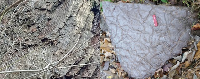
The Rome is a heterogeneous formation of red, maroon, brown and green colored sandstone, siltstone and shale and local beds of gray limestone and dolomite. The total thickness of the Rome may reach 2000 feet. This thickness and the evidence of a shallow-water depositional environment seem contradictory but it must be remembered that deposition was taking place over a very long period of time. Sedimentary structures which point to a tidal flat type of environment are: mud cracks, halite crystal casts, ripple marks, rain prints, tidal balls, current lamination, ripple lamination, flaser and lenticular bedding. Several of these structures are visible at this exposure, however fossil remains are scarce at this site. Below are photos from this site showing ripple marks (L) and mud cracks (R).
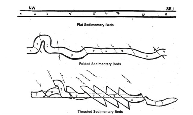
About 250 million years ago, the continent of Africa collided with North America. This collision left North America with a “crumpled fender” that we now know as the Valley and Ridge province and the Appalachian Mountains. The collision buckled, folded, and faulted the flat sedimentary beds so the land surfaces were collapsed like a telescope being closed. Geologists call this thrust faulting and the process moved the land as much as 60 miles westward causing fault blocks to slide up over one another. See illustration below where the arrows indicate thrust fault lines and the numbers indicate fault blocks in the final formation.
The posted coordinates bring you to a naturally-formed gap in one of these ridges exposing Rome Formation fault blocks.
In order to achieve this EarthCache, log your visit and complete the requirements below. When we review your logging task answers, if there is a problem, we will contact you to resolve it. If there is no problem, then your log stands. Any pictures or logs giving away the answers will be deleted.
Message us with the following:
- The text "GC6WQVN Rome Formation at Moore’s Gap" on the first line.
- How many fault blocks do you see in this exposure? Fault blocks are distinguished by noting the repetion of strata from one block to the next. Look for repeating rock types not just repeating colors. The thicker beds of limestone are good indicators. Each repetition is a fault block.
- Dip angle is the angle at which strata are inclined to the horizontal plane. Vertical strata have a dip angle of 90 degrees. Horizontal strata have a dip angle of zero degrees. Find the lowest dip angle you see here. (a) Describe where that is located along the cliff. (b) Using a protractor or inclinometer app if necessary, give this dip angle to within 10 degrees?
- OPTIONAL, extra credit: there is a small example of an overturned fold exposed here. This is a fold where the strata have completely folded back on themselves. Its shape resembles a hairpin. If you locate this, explain where along the cliff you found it.
Photos are always welcome - especially if you find an interesting structure worth sharing with others. Please, no spoilers.
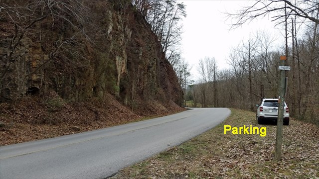
Answers can be obtained from the parking area across the road. But the fun stuff to see is at the base of the cliff. If you do cross the road here be careful. There is limited sight distance for southbound vehicles where you cross. At the base of the cliff there is enough room to safely explore the site. Be aware that there can be falling rocks. Below is a view of the site and the nearest parking. Other parking is available about 500 feet south of the cliff in a church parking lot and you won't need to cross the road. GPS accuracy is poor near the cliff but where you want to go will be obvious once you get close.
Congratulations to Ol'Fogie and janbears on their co-FTF.
The above information was compiled from the following sources:
-
Byerly, Don W. The Last Billion Years: A Geologic History of Tennessee. Knoxville: The Univesity of Tennessee Press, 2013. Print
-
Samman, Nabil Fahmi, "Sedimentation and Stratigraphy of the Rome Formation in East Tennessee. " PhD diss., University of Tennessee, 1975
-
Spigai, Joseph John, "A Study of the Rome Formation in the Valley and Ridge Province of East Tennessee. " Master's Thesis, University of Tennessee, 1963
-
http://geology.utah.gov/map-pub/survey-notes/glad-you-asked/what-is-a-formation/
-
Personal conversations with David Hackett, local geologist.