Special thanks to Jennifer Waughtal, MSc (Natural Resources and Environmental Studies) for her help with the proofing of this Earth cache.
The Fraser River begins its journey downhill from the high point of Fraser Pass, near Mount Robson. The Fraser River then flows progressively downhill for 1,375 km, running first due West to Giscome, then turning South until it reaches the Pacific Ocean at Vancouver, BC, Canada. This incredible length makes the Fraser River the longest river in British Columbia. During its long winding course across the province, the Fraser River gains significant volume of water from a large number of tributaries - enough volume to be the largest contibuting river to the Pacific Ocean and the fifth largest river in Canada.
The water of the Fraser River begins very clear in Mount Robson Provincial Park, where it provides many wonderful photo opportunities, such as Overlander Falls - a short hike off Highway 16.
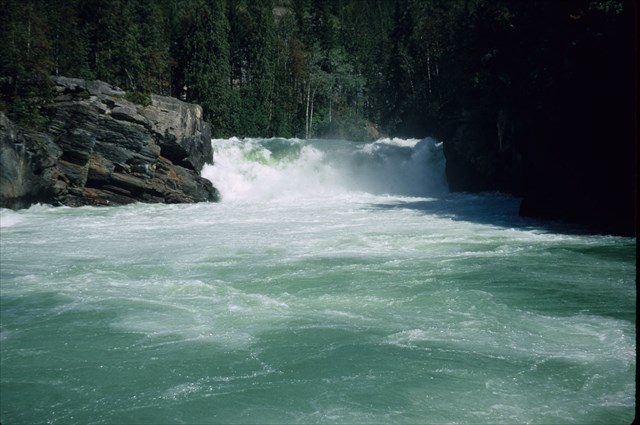
By Roland Neave (Own work) [CC BY-SA 3.0 (http://creativecommons.org/licenses/by-sa/3.0) or GFDL (http://www.gnu.org/copyleft/fdl.html)], via Wikimedia Commons
Where a tributary joins a river is known as a confluence. Cottonwood Island Park sits at the confluence of the Nechako River and the Fraser River. Other notable confluences of the Fraser River include the Chilcotin River near Williams Lake, BC, the Bridge and Setton Rivers at Lillooet, BC, the Thompson River at Lytton, BC, and the Harrison and Sumas Rivers at Chilliwack, BC.
At each confluence, the rivers come together and mix their waters. Confluences can show a sharp line where the two waters mix, especially when the clarity of the water is very different. The Fraser River, due to its high volume and high velocity coming from the Rockies, picks up an incredible amount of sediment - 20 million tonnes of sediment annually - which is carried downstream. The result is a muddy water, often described as dirty. The image below shows the mixing of the muddy Fraser River with the clearer Thompson River at Lytton, BC.
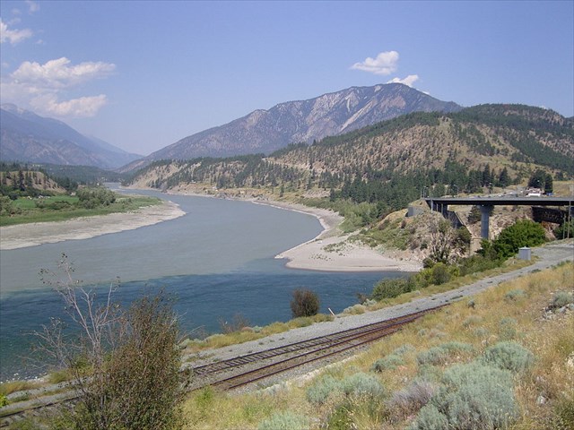
By Cash4alex (Own work) [CC BY-SA 3.0 (http://creativecommons.org/licenses/by-sa/3.0) or GFDL (http://www.gnu.org/copyleft/fdl.html)], via Wikimedia Commons
Some sediment is deposited any time the water slows down. The bulk of the sediment is eventually carried down to the Lower Mainland, where the confluence with the Pacific Ocean deposits the sediment. This sedimentation created the island of Richmond, BC. (King, 2013). However, eddies (where the water circles back on itself), and slow bends in the river also cause sediment to drop out of the water. The result of the sediment dropping out is typically sandy beaches and riverbeds in slow-moving locations.
The confluence of the Fraser River and the Nechako River, however, has unique sedimentation due to the physical orientation of the rivers. The Nechako River flows roughly due East as it reaches the confluence, while the Fraser River flows due West entering the confluence. The result is that the speed of the water from one river greatly slows down the speed of the water from the other river, which makes the water flowing Southwards out of the confluence very slow.
As can be expected, this slowing of the water allows for the deposition of silt across the river. One piece of evidence of this deposition is Goat Island. High water times, such as flooding events, caused the deposition of larger sediment (such as rocks) near the middle of the river. These larger sediments, such as rocks, then trap smaller sedimentation, such as sand, creating the island.
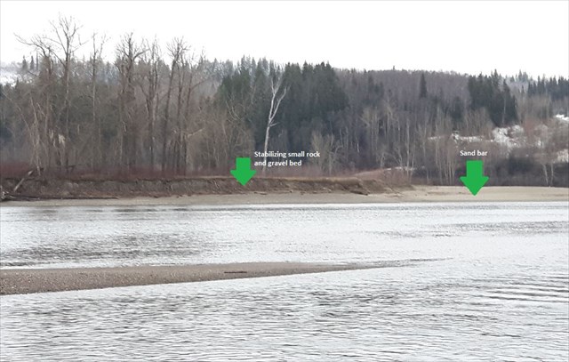
Photo is my own work. Taken Nov. 26, 2016.
During periods of low water, the exposed silt-beds received seeds from cottonwood trees and grasses. These seeds took root, and created a stabilization of the silt-beds which have allowed the island to resist eroding away during high water times.
To log this earthcache, you must email or message me the answers to the following questions. Do not post answers in your logs, as they will be deleted. Logs without supporting emails will also be deleted.
1) What evidence can you see of sedimentation along the confluence shoreline?
2) What direction does the Nechako River flow into the confluence? What direction does the Fraser River flow into the confluence? How do these flows interact?
3) Why would sedimentation occur at the particular location of Goat Island? (It may be easier to explain why not higher upstream or lower downstream.)
4) What do you think would happen if the trees were removed from Goat Island?
5) Photos are always appreciated but are not required.
Sources:
Waughtal, J. (Nov. 24, 2016). Personal Correspondence
King, S. (Mar. 01, 2013). My sentiments on sediment. Fraser River Discover Center. Retrieved from https://fraserriverdiscoverycentre.wordpress.com/2013/03/01/my-sentiments-on-sediment/.
Wikipedia. (Last updated Oct. 27, 2016). Fraser River. Retrived from https://en.wikipedia.org/wiki/Fraser_River.
Wikipedia. (Last updated Oct. 5, 2016). Confluence. Retrieved from https://en.wikipedia.org/wiki/Confluence