[JP]
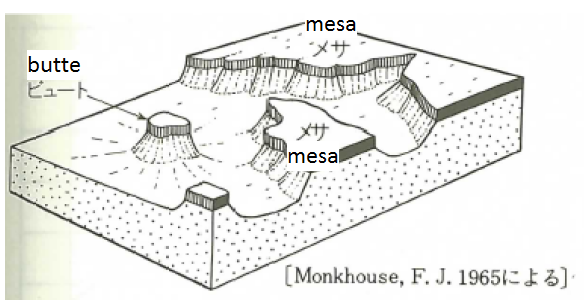
屋島は、起伏が緩やかな台地状を呈し、山頂が屋根のように平らな形をしていることからその名前が名付けられました。このような地形は「メサ」と呼ばれます。1934年(昭和9年)に、貴重な地形の屋島を保護しようと、国の天然記念物にも指定されました。
[EN]
Yashima has a table-like shape. Such a land feature is called "mesa." Yashima has been assigned as a natural monument since 1934 for preserving its valuable land feature.
「メサ」とは/What is "mesa"?
[JP]
メサとは,水平な硬岩層が浸食に抵抗して生じた平坦な頂面と、周縁の急な崖とをもつ台地の地形(新版 地学事典,1996)、あるいは水平な硬岩層におおわれ、周囲の一部を急崖で囲まれたテーブル状の高地と定義されていいます(下図:地形学事典,1981)。なお、メサがさらに浸食を受けて小さくなったものをビュートと呼びます。
[EN]
"Mesa" is a table-like land feature having a plat top surface of hard rock, which resists erosion, and steep cliff therearound(Geology Dictionary, 1996) (see the figure below). When mesa is further eroded and becomes smaller, it is called "butte."
屋島のメサ構造の成り立ち/The mesa structure of Yashima
[JP]
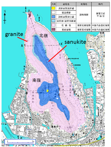
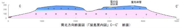
屋島のメサ構造は、花崗岩を基盤とし、最上部には讃岐岩質安山岩が水平にのっています(下の平面図、及び断面図(平面図のc-c’断面)参照)。最上部の讃岐岩質安山岩は、約1400万年前の火山活動で噴出した溶岩が水平に流れ出したものです。この讃岐岩質安山岩は硬く、浸食に耐える一方、下位の層は浸食されたやすいため、讃岐岩質安山岩の層の周囲に急崖が形成されました。また、南から屋島寺へ向かう遍路道沿いには、讃岐岩質安山岩が水平方向に延びた奇岩「畳石」が存在しています。畳石は、厚さ2~5cmの板状の安山岩が積み重なった板状節理で、讃岐岩質安山岩の元となった溶岩が冷却される過程で形成されたと考えられます。
[EN]
The mesa structure of Yashima has the bedrock of granite, and the top rock of sanukitic andesite (see the figures below of the top view and its c-c'cross-section view). The top sanukitic andesite is made of lava which erupted and horizontally flew in the volcanic activity about 14 million years ago. This sanukitic andesite is hard and resists erosion, while the layers thereunder is less resistant to erosion, thus the steep cliff has been formed around the top layer. On the trail, you can observe an oddly-shaped rock, "Tatami rock." The "Tatami rock" is tabular joint with stacked tabular sanukitic andesite rocks of 2-5 cm thick. This tabular joint was formed when lava was cooled.
タスク/Tasks for your found log
[JP]
以下のクイズの答えをキャッシュオーナーに送ってください。
[EN]
Send your answers for the quizzes below to the cache owner.
Quiz 1
[JP]
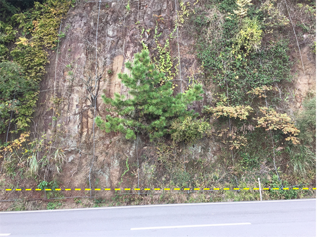
Additional Waypoint "Observation Point 1"では、屋島の最上層である讃岐岩質安山岩と、基盤岩である花崗岩との境界(下写真の黄色破線付近)を観察することができます。最上層の讃岐岩質安山岩と基盤岩の花崗岩との硬さの違いを観察してみましょう。(1)どのような違いがあるか、及び、(2)その違いによって屋島の台地状地形が何故形成されたのかについて、回答してください。
[EN]
At Additional Waypoint "Observation Point 1," you can observe a boundary between the top layer of sanukitic andesite and the bedrock of granite (look around the yellow dash line in the picture below). Please observe a difference in hardness between the top layer and the bedrock, and answer to the questions; (1) What is the difference? (2) How has the difference in hardness caused the table-like shape of Yashima?
Quiz 2
[JP]
Additional Waypoint "Observation Point 2"の山側斜面で観察される讃岐岩質安山岩は、マグマが冷却された際に生じる特有の構造をもっています。どのような構造でしょうか?
[EN]
The sanukitic andesite you can observe on the uphill slope at Additional Waypoint "Observation Point 2" has a unique structure which is formed when magma is cooled. What is the unique structure?