Chippokes Plantation State Park is open from dawn to dusk and charges a daily parking fee (as of 2020, $7 per day). A yearly park pass is also available.
This cache is best visited at low tide so you can explore more of the beach without getting your feet wet. Check the tide schedule here.
Additionally, the park offers guided fossil walks from time to time, meeting at the parking coordinates for this earthcache and going directly to the coordinates for the cache itself. Fossil walks also start off with a view of the park's fossil collection, so you can see what other fossils you might encounter down on the beach. To see the schedule of upcoming events at Chippokes Plantation, visit the park web page
FORMING THE BLUFFS - THE YORKTOWN FORMATION
Based on current scientific theory, around five million years ago, during the time known as the late Miocene epoch, everything you see around you was at the bottom of the Yorktown Sea. Back then, the Virginia coastline was about 40 miles further west, running roughly north to south through what is now Richmond. The Yorktown Sea was warm, shallow, and tropical, teeming with life, especially mollusks (shellfish and snails). Temperatures were around 2.5 ̊ C (4.5 ̊ F) warmer than today.
Over time, deposits thickened at the bottom of the ocean and began to cement together in places. Sand, clay, silt, and especially shells formed a sedimentary layer now called the Yorktown Formation. Originally hundreds of feet thick, the formation weathered away over time. In some places, such as here along the James River and north along the York River, the Yorktown Formation remains thick and is visible above ground.
In 1971, geologist Joseph Hazel dated the overall formation of the Yorktown Formation from the late Miocene (about 5 million years ago) to early Pliocene (about 2.5 million years ago) by studying the fossils in the sediment, specifically, ostracods, or small shrimp. In 1980, geologists Lauck Ward and Blake Blackwelder further divided up the Yorktown formation into separate layers, or members. They studied and distinguished the shellfish in each layer in order to correlate each member to a more specific time period. One member of the Yorktown formation, the Sunken Meadow Member, was distinguishable as being the only layer that contained a particularly large fossilized scallop shell, called...
CHESAPECTEN JEFFERSONIUS
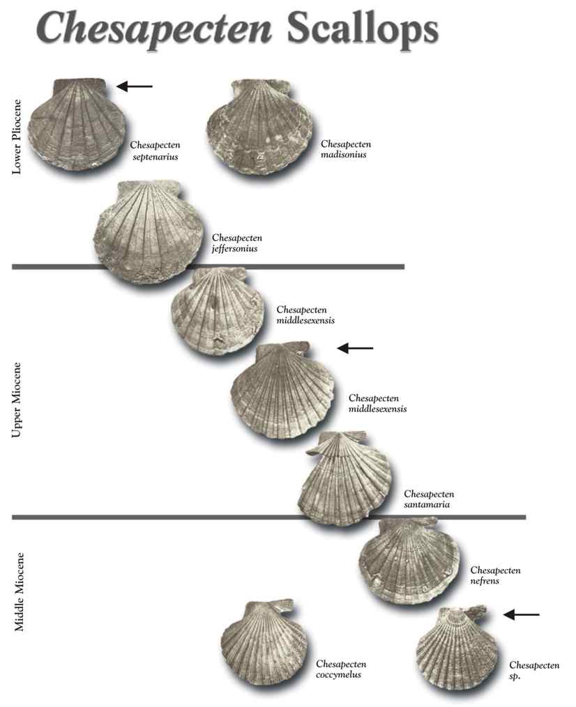
In 1687, Martin Lister, an English naturalist, published volume III of his "Historiae Conchyliorum," comprehensive publication on shells. The book contained an engraving of a large fossilized scallop, now known as Chesapecten jeffersonius, making it the first North American fossil to be illustrated in scientific literature. One of the larger scallops, C. jeffersonius shells measure from 7 to 11 inches across and have between 9 and 12 distinct ribs (ridges) radiating out from the base of the shell, as well as a very rounded edge.
C. jeffersonius can often be found lying on top of a layer of older sediment, the Eastover Formation, which scientists theorize was formed between 8.5 - 5 million years ago. It is similar in consistency to the Sunken Meadow member of the Yorktown formation, with one main difference -- the older, lower layer is thickly layered with smaller scallops, Chesapecten middlesexensis. These older cousins can be distinguished by their smaller size; they also have more numerous but less prominent ribs radiating out from the base of the shell.
C. jeffersonius also has a younger cousin, Chesapecten madisonius, which appears in the newer Rushmere member of the Yorktown formation, above the Sunken Meadow member. C. madisonius is large like its older cousin but usually has more, smaller ribs. You can check out this chart that shows the differences among these three scallops:
In 1993, Chesapecten jeffersonius was named Virginia's official state fossil, per Code of Virginia § 7.1-40.6.
DID YOU SAY FOSSILS? THESE JUST LOOK LIKE SHELLS!
It's hard to believe that all these shells strewn on the beach are actually fossils, but technically they are -- "fossils" are any trace of past life, however preserved. That isn't to say that these shells have undergone massive changes, such as the processes that preserve dinosaur bones or petrified wood. Limy shells that are buried in sediment, as here, don't undergo much change at all, other than some decay and loss of color. In some cases, several shells may have become cemented together with calcium carbonate.
Chesapecten jeffersonius isn't the only fossil you may encounter on the beach. Shark teeth (including megalodon), whale bones, sponges, snails, and clams have all been found here. If you take one of the park's fossil walks (see above; not required to log this cache, but HIGHLY RECOMMENDED), you can see some of the treasures that have been preserved in the bluffs for us to enjoy today.
LOGGING THIS EARTHCACHE
To log this earthcache, send us a message or an email and copy and paste these questions, along with your answers. Please *DO NOT* post the answers in your log, even if encrypted. There's no need to wait for confirmation from us before you log, but we will reply to messages and to emails if you include your email address. Group answers are fine; just let us know who was with you.
1. The name of this earthcache: Chesapecten jeffersonius: Virginia's state fossil
2. At the coordinates:
a. Examine the bluff face and describe it - color, texture, shell layers, etc.
b. Using the cues in the reading above and looking at the shell layer at the coordinates, can you identify which formation or formations are visible at the bottom of the bluff?
3. Can you identify any C. jeffersonius shells on the beach? What other fossils do you see, either in the rock face or on the beach? (No scientific names required, just describe what you see.)
Photos of your visit are optional but highly encouraged and greatly appreciated.
SOURCES
J.E. Hazel, "Ostracode biostratigraphy of the Yorktown Formation (upper Miocene and lower Pliocene) of Virginia and North Carolina," US Geological Survey Professional Paper 704, 1971.
L.W. Ward and B.W. Blackwelder, "Stratigraphic revision of Upper Miocene and Lower Pliocene beds of the Chesapeake Group, middle Atlantic Coastal Plain," US Geological Survey Bulletin 1482-D, 1980.
L.D. Campbell, "Pliocene mollusks from the Yorktown and Chowan River Formations in Virginia," Virginia Division of Mineral Resources pub. 127, 1993.
Bob Moss, "Geology of Virginia," American Society of Highway Engineers, 2014.
Alton Dooley, "Updates from the Paleontology Lab - Chesapecten jeffersonius," Virginia Museum of Natural History, 2009.
"Virginia State Fossil," eReferencedesk.
"Chesapecten fossils," American Geosciences Institute.
"Fossilization - How Fossils Form," Virtual Fossil Museum.
Wikipedia
This earthcache was placed with the permission of the Virginia Department of Conservation and Recreation and Chippokes Plantation State Park, and an approved VSP geocache permit is on file.