Important Information:
- This EarthCache is located at Cramond Island in Edinburgh, Scotland, which is free to enter.
- It is strictly advised that anyone who goes to the island to please check the times for the tides, so that nobody is caught out and stranded on the island, or worse yet, swept out to sea. There have been stories of people having to be rescued by the Coastguard in the past.
- I accept answers for this earthcache via email or by Private Messaging and will endeavour to reply to all queries within a few days. Please do NOT post your answers in your log, or I'll delete it. Also, answers must be submitted within 2 days of the log - no answers after 2 days will result in me deleting your log!! Pictures are completely fine in your logs though :)
- The Terrain for this is a T3.5 as you still have to find the Military ruin Waypoint to answer one of the questions - please take care as some of the paths are really slippery - especially if you go through the woods.

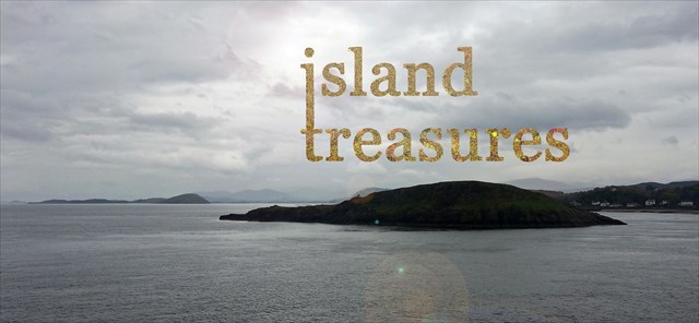
CRAMOND ISLAND
Cramond Island, meaning "island of the fort on the Almond river" is one of 43 tidal islands that can be walked to from the mainland of Great Britain and one of the 17 islands that can be walked to from the Scottish Mainland. You can see Arthur’s Seat and the Pentland Hills in the distance if you look carefully.
The path on the causeway is known as the Drum Sands. The walk around the island can take an hour and a half, but please take care if going into the woods if you fancy going to see the old farmhouse structures. The island is 1/3 mile long and covers 19 Acres and lies on the foreshore at Cramond.
Cramond Island was once a popular place for oyster fishing but stopped due to overfishing – this could have taken place on the north shore as there are remains of a stone jetty, which could go back to medieval times. The island later became a popular holiday destination, which all stopped by the Second World War.
It is possible the island may have a significant link to the prehistoric times and the people who lived there, as at least one stone burial cist was discovered there. It’s not proven, but since Cramond itself was used as a Roman outpost, the island may have also been used by them. Ownership of the island dates back as early as 1574, when the Bishop of Dunkeld sold the island to the Barnton Estate. The island is now owned by Dalmeny Estates and is currently uninhabited.
At one point The British Wood Society grazed sheep on the island in the 1790’s and the land was farmed up till the last farmer died in 1904 (Peter Hogg).
The rocks to the northwest of the island called SEAL ROCK is where you have the best chance of seeing marine life and is the location you’ll have the best chance of seeing the greatest number of whales that have beached in the River Forth.
From the North side, you can see Inchmickery. The island is now a Special Protection Area due to the range of breeding sea birds. If you’re going in the winter, keep an eye out for the birds who migrate to the shores.


Geological features and history:

Cramond Island is tidal and can be accessed via the causeway at low tide. The whole island is made of microgabbro, formerly known as dolerite. This igneous rock is created when magma cools below ground forming an intrusion that is younger than the sedimentary rock. The volcanic rocks at the start of the island have large cracks in the rock facing, which indicate a rock without layering, which make this section non sedimentary. The majority of the island is a giant volcanic rock, with some sandstone mixed in amongst all the concrete structures around the island.
Cramond Island is a volcanic sill which is formed by sideways intrusion that created a horizontal layer parallel to the existing sedimentary strata. Cramond Island still contains large crystals, indicating the magma cooled over a long period of time. The sill was tilted slightly by later tectonic movements, and it now slopes to the west. This is responsible for the shape of the island to this day, with a long gentle slope to the west and cliffs on its eastern side.
The tough rock has created a ramp for ice sheets moving east, which have slid up an over the island smoothing and polishing its western slope. In contrast to this, the eastern slope has had blocks plucked of it by the moving ice, forming a cliff. There was also a quarry on the island during the 18th and early 19th centuries, which was later filled in and no longer clearly visible now.
The causeway is almost a mile long and takes approximately 20 mins to walk. The big concrete triangular blocks along the east side of the causeway form the Anti-Submarine Defence Boom, which was formed during the second world war. If going to the island, the coastguards recommend you only attempt the crossing during the 2 hours either side of low tide.
Military history:
There are 75mm gun emplacements on the front of the island. The island was fortified as part of the Middle defences of the Firth of Forth in 1915. The anti-Submarine barrier runs from Cramond to Braefoot, via Inchmickery and Inchcolm Islands. There were 14 12-pdr (also known as 12 pounders) guns supplied to the 3 islands and of those islands, 2 were placed on Cramond Island.
They remained until the end of the war and were returned to the Navy by 1921. When WW2 started, the island had the two 12-pdr’s remounted on the original emplacements.

Buildings on the island included:
- Accommodation camps
- Engine houses (2 of which still stand today)
- Searchlight platforms
- Ancillery buildings
The two 12 pounder guns were intended as a defence against motor torpedo boats. The surviving structures – 1 circular gun emplacement, with metal runners, 3 elongated D-Plan concrete structures with small arms slits facing seaward, 1 elongated D-Plan concrete structure facing seawards (coast artillery searchlight), 1 roofed concrete building with raised floor and internal trenches. From 1939 the coastal batteries were strengthened against aerial bombardment by roofs being added.
4 of the 5 permanent searchlight emplacements built batteries on Cramond Island survive to this day.
To register this earthcache, answer the following questions:
QUESTIONS:
- Starting from the posted coordinates, you should be standing in front of the volcanic sill (in the first picture). Looking carefully at the volcanic rock faces, you should see tiny holes in the rocks - describe how they are made.
- The geology of Cramond consists of calciferous sandstone, which mixed with 2 later sills to give it's characteristic soil, which is coloured ???? (describe as best as you can what colour it is)
- What is the whole island made of, and describe as best as you can what colour the mineral is.
- What do the large crystals indicate?
- What is the name of the line of the concrete triangles along the causeway to and from the island, and what was the purpose of these blocks?
- Standing at the Waypoint for the Military storeroom ruin, close to the nearby cache "Go Forth", you'll see a doorway. Inside this doorway (on the right side) of the doorway there is a mixture of different rocks - describe (by sight and touch) the differences between the two main rocks you see at this location (To clarify, the 2 rocks are like opposites of each other).
- (OPTIONAL) – Take pics of yourselves around the causeway/ and or the island :)
Many thanks for the people at the Dalmeny Estate for granting permission for this Earthcache, and please take care to watch out for the rising tides when going to/from the island – information on the tides can be found online, and also on the board just before the causeway.
Thanks also to terratin for her help in giving me a crash course on geology for this earthcache :) and thanks to the reviewer geoawareUK2 for his feedback and suggestions on this cache.
There is a parking and seating area just before causeway, and there are plenty of local Lothian buses that go along to Cramond (Lothian bus 41 is the best bet here).
Please submit your answers before logging the find – if there are any problems, I’ll get back to you as fast as I can.
If you'd like to place a cache in this series, you are most welcome. There are just a couple of points to note:
1. Email den sure kalkun about your cache before you publish it. He will allocate a number to you.
2. Then let him know when it's published, and he'll add it to the bookmark list.
3. The island must be an actual island. Places with the name "Island" or "Isle" that aren't actually islands are not allowed. Any island is ok: sea, river, lake. It doesn't have to be a named island.
4. Only one "Island Treasures" physical cache per island. Sorry if your favourite island is already taken :) </>
5. You can place any type of cache in this series (Earth caches are particularly encouraged!) but the final container, if there is one, must be on the island.