The Blue Nile originates in the Tana lake in Ethiopia. It runs south and then west and north again to enter Sudan and there join the White Nile to form the Nile river. After joining it runs north to Egypt to end up in the Mediterranean sea.
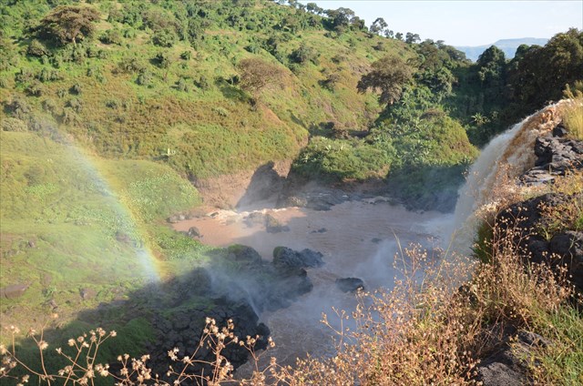
Some 30 km out of Bahir Dar and Tana Lake, near the small village, you can find the spectacular Blue Nile Waterfalls. In Amharic called Tis Abai, meaning great smoke or Tis Isat, smoke of fire. The waterfalls are around 40 meters high and can be up to 400 meters wide in the rainy season, consisting out of four streams. Unfortunately in the dry season a great part of the water is diverted to the hydroelectric plant, making the waterfalls less impressive as they used to be.
Gorge formation
A gorge is a narrow valley with steep, rocky walls located between hills or mountains and has a source of water flowing through the bottom of the valley. The term comes from the French word gorge, which means throat or neck. A number of natural forces form gorges. The most common is erosion due to streams or rivers. Streams carve through hard layers of rock, breaking down or eroding it. Sediment from the worn-away rock is then carried downstream. Interestingly, lava flow can also create gorges much like water does. The movement and melting of glaciers can also produce gorges. Glaciers cut deep valleys into the Earths surface.
Geologic uplift also forms gorges. Geological uplift is defined as the vertical elevation of the Earth's crust or surface. Erosion and geologic uplift often work together to create gorges. Parts of streams or rivers can be elevated, along with land, during the process of geologic uplift. As rivers or streams flow across this uplifted surface, waterfalls form.
To visit the waterfalls, you start from the village, either by crossing some fields and pass a small stream by boat, or a nice rocky walk with beautiful views on the waterfall, passing an old Portugese stone bridge (1626) and a suspension bridge. Or a combination of the two options. You may visit the falls as part of an organised trip or book a trip in Bahir Dar or if you go there all by yourself you have to buy a ticket to visit the falls in the nearby small village. Inform in Bahir Dar or check your travel guide for the option that suits you best.
To log this earthcache answer the following questions:
- Estimate the width of the waterfalls at the moment of your visit.
- What is the color of the water and what is the link with the name of the river?
- Go to the suspension bridge. Your crossing a gorge here. Which of the earlier mentioned forces of nature created this gorge? A hint can be found by the type of rocks you find here.
- Optional take a picture of yourself with the waterfall. All pictures are highly appreciated