french / français:
La géologie de Madagascar
Madagascar doit son origine à la tectonique des plaques et aux déplacements continentaux.
Même il y a 200 millions d'années, l'Amérique du Sud et l'Afrique faisaient partie d'un seul grand continent, le Gondwana, en plus de l'Australie, de l'Antarctique et du sous-continent indien. Celui-ci s'était à son tour séparé du continent géant original Pangée.
Il ya environ 165 millions d'années, un autre mouvement de démolition a commencé et Gondwana a éclaté dans les différentes parties encore existantes aujourd'hui. Madagascar est devenu une île il ya environ 65 millions d'années. À cet égard, Madagascar n'a pas été créé par l'activité volcanique, bien que, bien sûr, il ya aussi de petites activités volcaniques sur l'île.
En tant que très petite excursion, un passage de la Wikipedia géologique est autorisé:
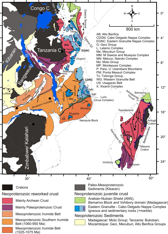 |
L'émergence de Madagascar se caractérise par une accumulation de structures géologiques différentes à partir de différentes zones géographiques d'origine et des phases de développement temporel. Il comprend des fragments de craton paléoarchiques et paléoprotérotiques dérivés d'autres cratons ainsi que des juvéniles néoprotérozoïques, c'est-à-dire des composantes arquées nouvellement formées de divers bassins océaniques. Au cours de l'orogenèse panafricaine, ces masses terrestres se sont unies pour former l'orogène de l'Afrique de l'Est formé il ya environ 550 millions d'années. L'Inde avec Madagascar s'est séparée d'environ 160 millions d'années d'Afrique. Il y a environ 90 millions d'années, la séparation de Madagascar et de l'Inde a eu lieu. Depuis, Madagascar a été séparé de l'Afrique par l'océan Indien. (Wikipedia, Image: H. Fritz, M. Abdelsalam, K.A. Ali, B. Bingen, A.S. Collins, A.R. Fowler, W. Ghebreab, C.A. Hauzenberger, P.R. Johnson, T.M. Kusky, P. Macey, S. Muhongo, n, R.J. Stern, G. Viola -) |
La croûte juvénile néoprotérozoïque formait la masse terrestre basale pour la formation ultérieure de la zone actuelle du Tsingy rouge. En particulier la zone, qui est appelée bouclier arabien-nubien, aussi comme bloc Bemarivo. Sur cette base, les sols latéritiques adaptés à ces conditions environnementales se sont formés au cours des millénaires et le climat tropical dominant. Ils sont un produit de surface formé par l'intempérisation intensive et durable des roches sous-jacentes, lorsque des précipitations et des températures élevées ont agi sur le sol, ce qui a conduit à l'accumulation d'aluminium ou d'oxydes et hydroxydes de fer dans le sol. Plus de la moitié de Madagascar se compose de formations de montagnes cristallines, qui ont émergé de roches de transition (métamorphites). Une autre grande partie se compose de formations sédimentaires. Dans toutes les formations, il existe de riches couches minéralogiques et d'huiles minérales.
Les sols de latérite, qui couvrent une grande partie de Madagascar, sont relativement humus, c'est pourquoi l'agriculture n'est pas très productive. Remède que nous avons créé par les coupe-feu, qui a cependant seulement un effet à court terme. En passant, ces brûlures de feu ont conduit à la découverte de la Tsingy rouge. Allons au Tsingy.
Il ya plusieurs endroits à Tsingys sur Madagascar.
Origine du mot "Tsingy" signifie "run on tiptoes" en malgache. Ainsi les aiguilles de pierre ou de pierre souvent pointues sont parfaitement décrites.
Mis à part les Tsingy Rouges, les autres sont tous à base de calcaire. Dans cette mesure, les Tsingy Rouges sont uniques dans le monde. Visitez ces structures éphémères aussi longtemps qu'elles existent.
Les Tsingys à base de calcaire se trouvent à Madagascar principalement dans 3 endroits connus:
- Tsingy de Namoroka
- Tsingy d'Ankarana
- Tsingy de Bemaraha.
Leur origine est principalement due à des bancs de coraux élevés de la mer, puis éradiqués par l'érosion éolienne et hydrique.
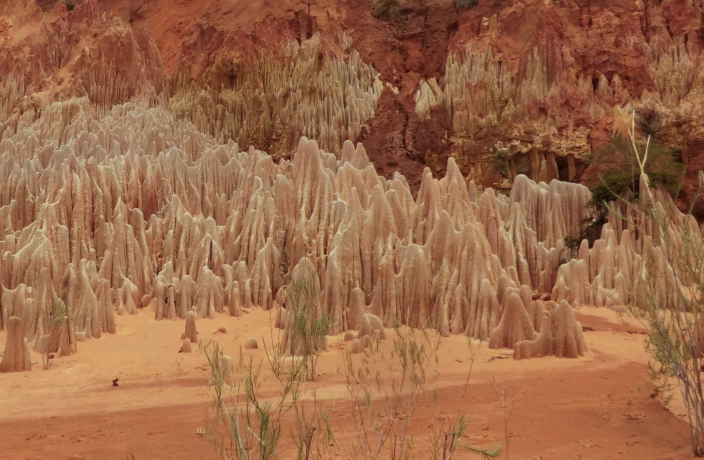
Le sujet de ce Cachet de Terre est cependant l'exception Tsingys Tsingy Rouges ou Tsingys Rouge au nord de Madagascar, près d'Antsiranana. Les Tsingys ont été couverts par des sols de latérite jusqu'à 20 m d'épaisseur et sont causés par des glissements de terrain. Par les eaux de la rivière Irodo. Ces Tsingy se composent principalement de grès (latérite), sur lequel aussi l'argile rouge a déposé. Au cours des millénaires, ces formations bizarres se sont formées dans le jeu de l'altération et de l'érosion. En raison de cette roche relativement molle à partir de laquelle ils sont faits, ils sont maintenant enlevés par l'érosion du vent et de l'eau, l'argile étant d'abord lavé. Au cours de ces processus hydromorphes, on peut voir des formations très intéressantes.
Par la route nationale 6 vous arrivez à la place jusqu'à 16 km. Il continue sur des pistes de sable et de gravier non pavées. Vous pouvez atteindre le canyon, où les Tsingys se produisent, donc seulement par 4WD véhicules (all-wheel drive). Du bord du canyon, un sentier mène aux Tsingys. En cas d'humidité, il existe un risque aigu de dérapage et une prudence est recommandée. Au fond, vous pouvez marcher passé les formations Tsingy. Malheureusement, ils ne s'allument pas aussi bien qu'au début de leur liberté. Certains facteurs, qui mènent aussi à une réponse, sont à blâmer. Quand le soleil se couche, ils doivent encore honorer leur nom. Malheureusement, nous ne pouvions pas attendre.
Pour enregistrer ce cache, nous aimerions répondre aux questions suivantes via un centre de messagerie ou un courrier électronique selon notre profil:
1. Allez aux coordonnées GZ et regardez autour. Que vois-tu?
2. Décrivez en vos propres mots vos impressions du Tsingy. Reconnaissez-vous des particularités?
3. Quels sont les Tsingys? La roche (matière) est responsable de la coloration.
4. En utilisant votre GPS, déterminer l'altitude au bord du canyon et la différence d'altitude entre le canyon (en haut) et le canyon où sont les Tsingy.
5. À environ la moitié de hauteur est un objet. Qu'est-ce que c'est ça?
Nous vous souhaitons beaucoup de plaisir à explorer les Tsingys et le voyage aventureux là-bas.
Selon les directives de Groundspeak, vous pouvez enregistrer ce cache après la visite sans attendre une réponse de notre part. Si quelque chose ne va pas, nous vous contacterons. Comme si les visites (Pseudo visites) ou du divan sans être GZ, ne sont pas acceptées et les journaux reconnaissables correspondants sont supprimés. Ne pas poster de photos pour répondre à nos questions.
English:
The geology of Madagascar
Madagascar owes its origin to plate tectonics and continental shifts. Even some 200 million years ago, South America and Africa were part of a single large continent, Gondwana, in addition to Australia, the Antarctic and the Indian subcontinent. The latter had, in turn, separated from the original giant continent Pangea.
About 165 million years ago, another demolition movement began and Gondwana broke into the individual parts still existing today. Madagascar became an island about 65 million years ago. In this respect, Madagascar has not been created by volcanic activity, although of course there are also smaller volcanic activities on the island.
As a very small excursion, a passage from the geological Wikipedia is allowed:
|
The emergence of Madagascar is characterized by an accumulation of different geological structures from different geographic areas of origin and temporal development phases. It comprises paleoarchic and paleoproterotic craton fragments derived from other cratons as well as neoproterozoic juveniles, that is, newly formed, arched components from various ocean basins. During the Pan-African orogenesis, these landmasses joined together as the East African orogen formed up to about 550 million years ago. India with Madagascar separated from about 160 million years ago from Africa. About 90 million years ago the separation of Madagascar from India took place. Since then, Madagascar has been separated from Africa by the Indian Ocean. (Wikipedia, Image: H. Fritz, M. Abdelsalam, K.A. Ali, B. Bingen, A.S. Collins, A.R. Fowler, W. Ghebreab, C.A. Hauzenberger, P.R. Johnson, T.M. Kusky, P. Macey, S. Muhongo, n, R.J. Stern, G. Viola -) |
The neoproterozoic juvenile crust formed the basal land mass for the later formation of the present area of the red Tsingy. In particular the area, which is called as arabien-nubian shield, also as Bemarivo block. On this basis the laterite soils suitable for these environmental conditions have formed over the course of the millenniums and the prevailing tropical climate. They are a surface product formed by intensive and long-lasting weathering of the underlying rocks, when high precipitates and temperatures have acted on the soil, which then led to the accumulation of aluminum or iron oxides and hydroxides in the soil. More than half of Madagascar consists of crystalline mountain formations, which have emerged from transition rocks (metamorphites). Another large portion consists of sedimentary formations. In all formations there are rich mineralogical and mineral oil layers.
The laterite soils, which cover a large part of Madagascar, are relatively humus, which is why agriculture is not very productive. Remedy we created by fire arresters, which however only has a short-term effect. By the way, such fire-burns led to the discovery of the red Tsingy. Let's get to the Tsingy.
There are several places in Tsingys on Madagascar.
Origin of the word "Tsingy" means "run on tiptoes" in Malagasy. Thus the often pointed rock or stone needles are perfectly described.
Apart from the "Tsingy Rouges", the others are all based on limestone. To this extent, the 'Tsingy Rouges' are unique in the world. Visit these ephemeral structures as long as they exist.
The limestone-based Tsingys are found in Madagascar mainly in 3 known places:
- Tsingy of Namoroka
- Tsingy of Ankarana
- Tsingy of Bemaraha.
Their origin is mainly due to coral banks raised from the sea and then eradicated by wind and water erosion.
Subject of this Earthcache, however, are the "exception-Tsingys" , Tsingy Rouges or Red Tsingys in the north of Madagascar, near Antsiranana. The Tsingys have been covered by up to 20 m thick laterite soils, and are caused by landslides. Through the waters of the river Irodo. These Tsingy consist mainly of sandstone (laterite), on which also red clay has deposited. In the course of millenniums, these bizarre formations have formed in the interplay of weathering and erosion. On account of this relatively soft rock from which they are made, they are now removed by erosion of wind and water, the clay being first washed out. In the course of these hydromorphic processes very interesting formations can be seen.
Via the national road 6 you reach the place up to 16 km. It continues on unpaved sand and gravel tracks. You can reach the canyon, where the Tsingys occur, therefore only by 4WD vehicles (all-wheel drive). From the canyon edge a trail leads to the Tsingys. In case of humidity there is an acute risk of skidding and caution is recommended. At the bottom you can walk past the Tsingy formations. Unfortunately, they do not light up as well as at the beginning of their free-rein. Some factors, which also lead to an answer, are to blame. When the sun goes down, they still have to honor their name. We unfortunately could not wait.
To log this cache, we would like to answer the following questions via message-center or email according to our profile:
1. Go to the GZ coordinates and look around. What do you see?
2. Describe in your own words your impressions of the Tsingy. Do you recognize peculiarities?
3. What are the Tsingys? The rock (material) is responsible for the coloration.
4. Using your GPS, determine the altitude at the edge of the canyon and the difference in altitude between the canyon (top) and the canyon where the Tsingy are.
5. At about half height is an object. What's this?
We wish you much fun exploring the Tsingys and the adventurous journey there.
According to Guidelines from Groundspeak you can log this cache after the visit without waiting for an answer from us. If something is wrong, we will contact you. As if visits (Pseudo visits) or from the couch without to be GZ, are not accepted and corresponding recognizable logs are deleted. Please do not post photos to answer our questions.
To all those who are too long on our listing, who find the omissions to be inflated and tiring, we recommend the use of the Guidelines about Earthcaches from Groundspeak (edition 2016) Guidelines.
German / Deutsch:
Die Geologie Madagaskars
Madagaskar verdankt seine Entstehung der Plattentektonik und Kontinentalverschiebung.
Noch vor etwa 200 Millionen Jahren waren Südamerika und Afrika neben Australien, der Antarktis und dem indische Subkontinent, Teil eines einzigen Großkontinents Gondwana. Der wiederum hatte sich vom ursprünglichen Riesenkontinent Pangäa losgelöst.
Vor etwa 165 Millionen Jahren begann eine weitere Abbruchbewegung und Gondwana zerbrach in die einzelnen, noch heute bestehenden Teile. Madagaskar wurde vor etwa 65 Millionen Jahren zu einer Insel. Insofern ist Madagaskar nicht durch vulkanische Aktivitäten entstanden, obwohl es natürlich auch kleinere vulkanische Aktivitäten auf der Insel gibt.
Als ganz kleiner Ausflug sei uns hier eine Passage aus der geologischen Wikipedia gestattet:
|
Die Entstehung von Madagaskar ist geprägt durch eine Ansammlung von unterschiedlichen geologischen Strukturen aus verschiedenen geografischen Ursprungsgebieten und zeitlichen Entwicklungsphasen. Sie umfasst paläoarchaische und paläoproterozische Kraton-Bruchstücke, die von anderen Kratonen abstammen sowie neoproterozoische juvenile, d. h., neugebildete, Inselbogen -Komponenten aus verschiedenen Ozeanbecken. Während der Pan-Afrikanischen Orogenese schlossen sich diese Landmassen zusammen als sich das Ostafrikanische Orogen bis vor etwa 550 Millionen Jahren, bildete. Indien mit Madagaskar löste sich ab etwa vor 160 Millionen Jahren von Afrika. Vor etwa 90 Millionen Jahren erfolgte die Separierung Madagaskars von Indien. Seitdem ist Madagaskar von Afrika durch den Indischen Ozean getrennt. (Wikipedia, Bildquelle: H. Fritz, M. Abdelsalam, K.A. Ali, B. Bingen, A.S. Collins, A.R. Fowler, W. Ghebreab, C.A. Hauzenberger, P.R. Johnson, T.M. Kusky, P. Macey, S. Muhongo, n, R.J. Stern, G. Viola -) |
Die neoproterozoic juvenile crust bildete die Basislandmasse für die spätere Entstehung des heutigen Gebietes der roten Tsingys. Im Speziellen die Fläche, die als arabien-nubian shield, auch als Bemarivo Block, bezeichnet wird. Auf dieser Basis haben sich im Laufe der Jahrmillionen und des vorherrschenden tropischen Klimas die für diese Umweltbedingungen geeigneten Lateritböden gebildet. Sie sind ein Oberflächenprodukt, entstanden durch intensive und lang anhaltende Verwitterung der zugrunde liegenden Gesteine, wenn hohe Niederschläge und Temperaturen auf den Boden einwirkten, die dann zur Anreicherung von Aluminium- bzw. Eisenoxiden und -hydroxiden im Boden geführt haben.
Über die Hälfte Madagaskars besteht aus kristallinen Gebirgsformationen, die aus Umwandlungsgesteinen hervorgegangen sind (Metamorphite). Ein weiterer großer Anteil besteht aus sedimentären Formationen. In allen Formationen kommen reichhaltige mineralogische und erdölhaltige Schichten vor.
Die Lateritböden, die einen großen Teil von Madagaskar bedecken, sind relativ humusarm, weshalb Landwirtschaft nicht sehr ertragreich ist. Abhilfe wir durch Brandrodungen geschaffen, was jedoch nur einen kurzzeitigen Effekt hat. Derartige Brandrodungen führten übrigens zur Entdeckung der roten Tsingys. Kommen wir also zu den Tsingys.
Es gibt auf Madagaskar an verschiedenen Stellen ‚Tsingys’.
Herkunft des Wortes „Tsingy“: bedeutet auf madagassisch „auf Zehenspitzen laufen“.
Somit werden die oft spitzen Fels- oder Steinnadeln perfekt beschrieben.
Bis auf die ‚Tsingy Rouges“ sind die anderen alle auf der Basis von Kalkstein entstanden. Insofern sind die ‚Tsingy Rouges’ nach heutigem Kenntnisstand einmalig auf der Welt. Besucht diese ephemeren Strukturen, so lange sie noch existieren.
Die auf Kalksteinbasis entstandenen Tsingys findet man auf Madagaskar hauptsächlich an 3 bekannten Orten:
- Tsingy von Namoroka
- Tsingy von Ankarana
- Tsingy von Bemaraha.
Ihre Entstehung verdanken diese Steinnadeln vor allem Korallenbanken, die aus dem Meer empor gehoben wurden und dann durch Erosion von Wind und Wasser ausgewaschen wurden.
Gegenstand dieses EC sind jedoch die „Ausnahme-Tsingys“ im Norden von Madagaskar, in der Nähe von Antsiranana.
Die Tsingys sind von bis zu 20m dicken Lateritböden bedeckt gewesen und erst durch Erdrutsche, hervorgerufen u.a. durch das Wasser des Flusses Irodo, zu Tage getreten.
Diese Tsingys bestehen hauptsächlich aus Sandstein (Laterit), auf den sich zusätzlich roter Ton abgelagert hat. Im Laufe von Jahrmillionenhaben sich im Zusammenspiel von Verwitterung und Erosion diese bizarren Formationen gebildet.
Auf Grund dieses relativ weichen Gesteins, aus dem sie bestehen, werden sie nun durch Erosion von Wind und Wasser abgetragen, wobei der Ton zuerst ausgewaschen wird. Im Verlauf dieser hydromorphen Prozesse sind nun sehr interessante Formationen zu sehen.
Über die Nationalstraße 6 kommt man bis auf ca. 16 km an den Ort.
Weiter geht es nur auf unbefestigten Sand- und Geröllpisten. Man erreicht den Canyon, in dem die Tsingys vorkommen, deshalb nur mittels 4WD Fahrzeugen (Allradantrieb).
Vom Canyonrand führt ein Wanderpfad zu den Tsingys hinab. Bei Feuchtigkeit entsteht hier akute Rutschgefahr und somit ist Vorsicht geboten. Unten angekommen kann man an den Tsingy-Formationen vorbei wandern.
Leider leuchten sie nicht mehr so schön wie am Beginn ihrer Freispülung. Einige Faktoren, welche auch zu einer Antwort führen, sind daran schuld. Wenn die Sonne untergeht sollen sie jedoch noch ihrem Namen alle Ehre machen. Wir konnten leider nicht solange warten.
Um diesen Cache zu loggen, möchten wir folgende Fragen per message-center oder email lt. unserem Profil beantwortet wissen:
1. Begebt Euch zu den GZ Koordinaten und schaut Euch um. Was seht Ihr?
2. Beschreibt mit eigenen Worten Eure Eindrücke von den Tsingys. Erkennt Ihr Besonderheiten?
3. Woraus bestehen die Tsingys? Das Gestein (Material) ist für die Färbung verantwortlich.
4. Ermittelt mit Hilfe Eures GPS die Höhe am Canyonrand über NN und den Höhenunterscheid zwischen Canyonrand (oben) und dem Canyongrund, wo die Tsingys stehen.
5. Auf etwa halber Höhe befindet sich ein Objekt. Was ist das?
Wir wünschen Euch viel Spaß beim Erkunden der Tsingys und der abenteuerlichen Fahrt dorthin.
Entsprechend Guidelines von Groundspeak könnt Ihr diesen Cache nach dem Besuch loggen ohne eine Antwort von uns abzuwarten. Sollte etwas nicht stimmen, melden wir uns.
Pseudobesuche oder von der Couch aus ohne an GZ gewesen zu sein, werden nicht akzeptiert und entsprechend erkennbare Logs gelöscht.
Bitte posted auch keine Photos, die zu Antworten unserer Fragen führen.
Allen, denen unser Listing zu lang vorkommt, die die Auslassungen zu aufgeblasen und ermüdend finden, sei hier die Kenntnisnahme der Guidelines von Groundspeak empfohlen (Stand 2016). Guidelines - deutsch.
Quellen: Wikipedia, Mineralienatlas.de, Mineral- & Fossilimport (mfimport.com)