Village Sign in Kelvedon.
The existing village of Kelvedon has been a settlement since the Early Middle Ages, though it stands near (and partly on) the site of a Roman settlement, probably Canonium. Kelvedon expanded significantly in the Victorian era. The reason was the Norwich to London railway making it a place to live yet get to work as rail was the only fast method of transport. Victorian Kelvedon was set along one street, High Street. In the 1930s, with the advent of the automobile, High Street became the A12, the main road through Essex. Ribbon development saw houses sprawl along the road for miles. The village suffered major congestion until a bypass was built in the 1960s.

There are several benches nearby.
Find NEWITT ABCD-EFGH and LANGSTONE JKLM-NPQR. Now for some maths:
The cache can be found at N 51 (H-D)(F-B).D(E-A)(M-G) E 0 (J+N+L)C.(D-C)(R-Q)(K-M)
You can check your answers for this puzzle on
About Village Sign Caches
|
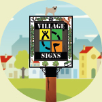 ⠀ ⠀ |
This cache belongs to the Village Sign Series, a series of caches based on ornate signs that depict the heritage, history and culture of the villages that put them up (generally on the village green!).
The signs can be made of different materials from fibreglass to wood, from forged steel to stone. They can depict anything from local industry to historical events. The tradition probably started in Norfolk or Suffolk and has now spread across most of the country so we thought we would base a series on them!
|
More information, bookmarks and statistics can be found at the Village Signs Website
If anybody would like to expand the Village Sign Series, please do.
I would ask that you request a number for your cache first at www.villagesignseries.co.uk
so we can keep track of the Village Sign numbers and names to avoid duplication.