Salina Unirea EarthCache
-
Difficulty:
-

-
Terrain:
-
Size:  (other)
Related Web Page
Please note Use of geocaching.com services is subject to the terms and conditions
in our disclaimer.
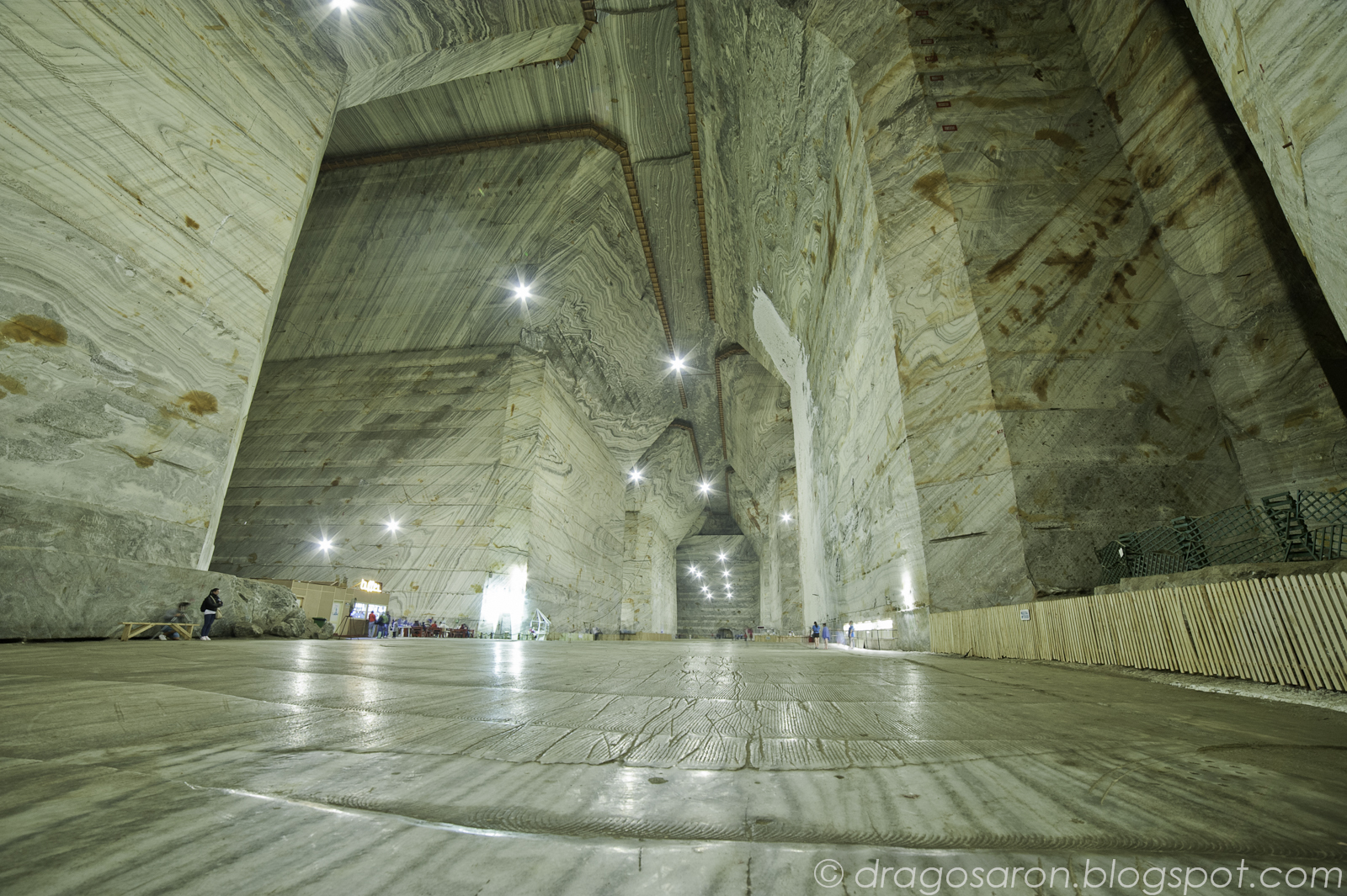
(EN) Slanic Salt mine one of the most important salt mines in our country, is situated in the Carpathian foothills region Prahova Valley Slanicului at a distance of 45 km from Ploiesti. Rock salt deposit is located in the city Slanic Prahova. Access to the deposit is made by road and rail. In terms of geographic region Slanic is situated in the hills of the Carpathians curvature. Morphology region is affected by landslides. Rock salt deposit has the lenticular shape with a length of approx. 2.7 km to the north - south width of the lens is between 800 and 2300m, and the maximum thickness is 499m. The lens appears to nest a bench blackish or black salt with a thickness of 5-25 m having a hardness greater than white or gray salt. Rock salt is white or gray compact, sometimes poorly cemented. Salt from Slanina has a coarse crystal structure widely developed, compact, sometimes poorly cemented. Microscopic analyzes carried out on samples taken from drilling operation have revealed the following minerals: Halite (NaCl) is the predominant mineral rock salt from Ocnele. It occurs at a rate of 94.50% average. It presents as crystals idiomorphous, hipidiomorfe or as granular masses xenomorfe. Sometimes crushing rock salt shows structures with deposits of clay minerals. The inclusions of clay minerals, salt figure gray coloration. Patchy rock salt has a pink coloration due to ferric oxide inclusions. Crystal sizes vary between 0,1-5mm.
To claim this earthcache please send me via profile e-mail the answer to the following questions:
1) Describe the salt in the mine (color, composition, taste...etc)
2) Why are some salt bricks are colored dark gray?
3) How is formed the halite?
Uploaded photos with you and/or your GPS in the Salt Mine are welcome!
(RO) Salina Unirea, una din cele mai importante mine de sare din țara noastră, este situată în zona colinelor subcarpatice din regiunea Prahova, pe Valea Slănicului la o distanță de 45 km de Ploiești. Zăcământul de sare gemă este situat sub orașul Slănic Prahova. Accesul la zăcământ se face pe sosea și pe calea ferată. Din punct de vedere geografic, regiunea Slănic este situată în zona colinară a curburii munților Carpați. Morfologia regiunii este afectată de alunecări de teren. Zăcământul de sare gemă are formă lenticulară, cu lungime de cca. 2,7 km pe direcția nord - sud, lățimea lentilei este cuprinsă între 800 și 2300m, iar grosimea maximă este de 499m. Sarea gemă albă sau cenușie este compactă, pe alocuri slab cimentată. Are o structură macrogranulară cu cristale larg dezvoltate, compacte, uneori slab cimentate. Analizele microscopice efectuate asupra probelor recoltate din forajele de exploatare au pus în evidență următoarele minerale: Halitul (NaCl) este mineralul predominant al sării geme. Apare în proporție medie de 94,50%. Se prezintă sub formă de cristale idiomorfe, hipidiomorfe sau ca mase granulare xenomorfe. Uneori sarea gemă prezintă structuri de sfărâmare cu depuneri de minerale argiloase. Incluziunile de minerale argiloase, dau sării o colorație cenușie. Pe alocuri sarea gemă are o colorație roz datorită incluziunilor de oxizi ferici. Dimensiunile cristalelor variază între 0,1-5mm.
Pentru a loga acest earthcache vă rog să-mi trimiteți prin e-mail răspunsul la următoarele întrebări:
1) Cum este sarea din mină? (gust, culoare, compoziție...etc)?
2) De ce mesele de sare au o culoare gri închisă?
3) Cum se formează halitul?
Fotografii încărcate cu tine și / sau GPSul în salină sunt binevenite!
Additional Hints
(No hints available.)
Treasures
You'll collect a digital Treasure from one of these collections when you find and log this geocache:

Loading Treasures