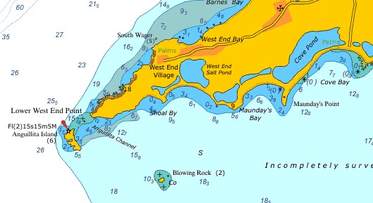
The West End Pond is a wetland on Anguilla
The West End Pond is a 19 ha brackish lagoon in the West End district, near the south-western end of the main island, and was historically used for salt production. It has a marl substrate and rocky shoreline and is divided by a culverted causeway that provides access to tourism development along the beach at Shoal Bay West. The eastern basin of the pond is roughly circular and about 370 m across, while the western section is longer and narrower. It is mostly surrounded by stands of black, white and buttonwood mangroves.
Salt ponds are shallow, mostly, artificial and designed to produce salts from sea water or other brines. Some salt ponds are a natural feature of both temperate and tropical coastlines. These ponds form a vital buffer zone between terrestrial and marine ecosystems. Contaminants such as sediment, nitrates and phosphates are filtered out by salt ponds before they can reach the ocean. The depth, salinity and overall chemistry of these dynamic salt ponds fluctuate depending on temperature, rainfall, and anthropogenic influences such as nutrient runoff. The seawater or brine is fed into large ponds and water is drawn out through natural evaporation which allows the salt to be subsequently harvested. The ponds also provide a productive resting and feeding ground for many species of waterbirds, including several endangered species. The ponds are commonly separated by levees. The salt ponds and inland marshes serve as excellent feeding grounds for Flamingos.
There are several salt ponds in Anguilla. These were formed when earlier coves became cut off from the sea by sand bars which formed across their mouths. As with similar sea-level salt ponds in other islands, they never completely dry out. Their bottoms are below the level of the nearby sea. As the brine becomes concentrated by evaporation, the salt precipitates out. It forms a thick crust on the bed some one or two feet below the surface.
A levee is a type of dam that runs along the banks of a river or canal. Levees reinforce the banks and help prevent flooding. By confining the flow, levees can also increase the speed of the water. Levees can be natural or man-made. A natural levee is formed when sediment settles on the river bank, raising the level of the land around the river.
To construct a man-made levee, workers placed rocks and sand to create them. Levees protect the land in many parts of the world. For example; In the US, you will find important levee systems along the Mississippi and Sacramento Rivers. And in Europe the Dutch do have made impressive levees. But the levees in a salt-pound do have an other function mostly.
Salt ponds are also sediments traps. Sediments that are washed onto the coast from more upland areas get trapped in the salt pounds around the island. This helps to protect reefs and seagrass beds since too much sediment can suffocate corals, clog the gills of fish, and bury the eggs of the aquatic animals that use these areas. Sediments also tend to include large amounts of dangerous nutrients and substances from fertilisers and pesticides that are washed into coastal waters from agricultural and heavily manicured lawns and landscapes. Both high nutrient and sediment levels can cause algal blooms and high turbidity (cloudiness) which limits the amount of light and oxygen in the water. Too little light could, in turn, stunt the growth of coral reefs and aquatic plants. Salt ponds are not only able to just stop those contaminants from getting into the sea, they can often change them through biological, chemical, and physical processes into harmless substances.
CONDITIONS FOR LOGGING
Mail the CO the answers to the questions below. Next they are judged on accuracy. When the answers are wrong or logged without having received any mail than the found-log will be deleted. This seems harsh and that is exactly what it’s meant to be, however, enjoy this environment.
1) Why was the salt production on Anguilla less energy consuming than in northern Europe?
2) The Levee direct at the give coordinates, is this manmade or natural development?
3) Do you think this salt pond is artificial made or a formed by a natural processes, and why?
4) How many meters above sea-level is this location?
The local cache- guardian is Anguillobster
Resources used for this geocache:
- Anguilla The National Biodiversity Strategy and Action Plan
- Wikipedia, the free encyclopedia
- The Anguilla Archeological and Historical Society
As an earthcache, there is no “box” or “container” to discover. Rather, with this cache, you discover something about the geology of the area. For more info, consult www.earthcache.org.