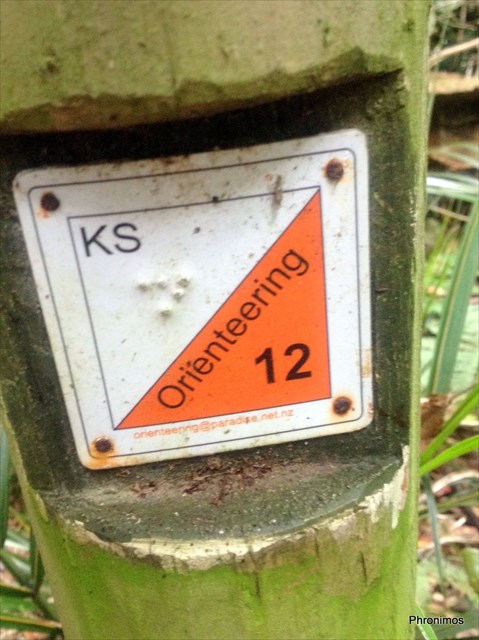
The permanent orienteering course in Pukekura Park utilises poles such as that above. They are around a metre high with a number on the slanting top. On the back you can see the orienteering "control"
Each pole has a number - in the example above 12
The "control" has a two letter code - in this example KS
There is also an unique "dot pattern" like braille (not needed for this geocache)
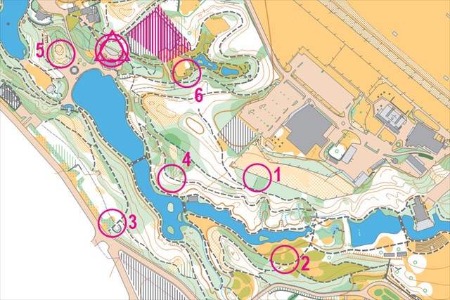
On the map above the circle within the triangle is the Start triangle and the Finish circle at the same place.
Run, jog or walk to visit each control. Record the necessary information and work out the location of the Final cache. The total route on well formed tracks can be walked in around 30 minutes. They can be done in any order.
Way
point# |
Location |
Control
number |
Code
letters |
Work out
Final |
| 1(=A) |
S 39° 04.002 E 174° 04.861 Track end |
|
|
1st letter - 2nd letter |
| 2(=B) |
S 39° 04.066 E 174° 04.853 Seat |
|
|
(1st letter + 2nd letter) ÷ 5 |
| 3(=C) |
S 39° 03.990 E 174° 04.702 Track junction |
|
|
1st letter |
| 4(=X) |
S 39° 03.970 E 174° 04.772 Track bend |
|
|
1st letter |
| 5(=Y) |
S 39° 03.845 E 174° 04.716 Hill top |
|
|
1st letter |
| 6(=Z) |
S 39° 03.896 E 174° 04.832 Garden edge |
|
|
1st letter |
| FINAL |
S 39° 04.ABC E 174° 04.XYZ |
|
|
|

For your further interest, Groundspeak, Inc also manage waymarks under their Waymarking.com
web portal. Phronimos placed here August 2010 Waymark WM9FRG: Pukekura Park Free [orienteering] Course, New Plymouth. Lodge your visit, logging into the website using your geocaching.com login.