|
There were 9 theropod footprints with the walk length measuring 2.5 ~ 27.4 m with the footprint length of 16 ~ 36 cm, with a total of 120 footprints. The region is composed of gray and dark gray shale, with steep slopes. A total 400 footprints, sauropods make up 120 footprints of 3 track ways, while theropods accounted for 135 footprints in 9 track ways.
The importance of dinosaur footprints Sinseongri mountainous areas is that it covers the most area on ground surface in the entire nation. Also, the walk length of large sauropod footprint trackway is the biggest in the nation, also among the small and medium-sized theropod trackways in good preservation, the length is the longest in the nation
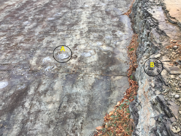
The strike and slope is N60E/33SE, with lower part consisting of gray sandstone, where the dinosaur footprints and dykes (dyke) appear. In the central area black mudstone is intercalated in the tuff layer. At the top green and black sandstone and mudstone appears in alteration. It is interesting that intercalated tuff appears in the upper strata of the dinosaur footprint.
Judging from the fact that dinosaur footprints are shown in the fine-grained clastic sedimentary rocks shale with dry heat(desiccation)(2), this region may have been the rim of a lake or a downstream river in the Cretaceous period. In addition, Sinseongri boasts graceful mountainous shapes with many rocky cliffs, a place where many people comfortably.
* (2) Dry heat(Desiccation) : See Stromatolites(영월 스트로마톨라이트)!
발자국은 어떻게 생기나
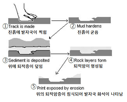
공룡의 발자국을 보아도 공룡이 어떻게 살았는지, 어떤 특징이 있었는지 많은 것을 추측할 수 있다.발자국을 보고 공룡이 두 다리로 걸었는지 네 다리로 걸었는지, 얼마나 빨이 걸었는지, 무리를 지어다녔는지 등도 알 수 있다. 공룡이 강이나 호수 근처의 진흙땅을 걸어간다고 생각해 보자. 이 진흙 땅위에 공룡이 걸어가서 생긴 발자국은 진흙땅이 햇빛을 받아 말라 단단하게 굳어 버릴 수 있다. 그위에 부드러운 흙과 모래가 층층이 쌓였다가 몇백만 년이 지난 뒤 다시 침식되어 없어지면 발자국이 다시 그 모습을 드러내게 되는 것이다. 과학자들은 어느 발자국이 어느공룡의 발자국 인지 정확히 알아내지는 못한다. 그러나 그 발자국이 만들어진 당시에 그 지역에서 살았던 것으로 여겨지는 공룡과 발자국의 크기와 모양을 비교해 보면 어느 정도 정확하게 짐작할 수 있다. 또 발자국이 발견된 암석이 만들어진 시기를 측정하여 발자국 주인이 살던 시기까지 알아낼 수 있다.
Fossil Trackways Formation
As dinosaurs travel they leave trails of footprints which may fossilize. The set of fossilized prints is known as a trackway. The study of trackways can provide information about the length, width, speed, weight, and number of legs of a dinosaur. Studying the sets of trackways can also give clues to the social structure of dinosaur groups, their prey, and hunting habits.
Dinosaur trackways are preserved for millions of years in rock. The dinosaur left marks when walking on soft ground, such as a mudflat or river bed. The soft material dried and hardened and the marks were filled in by mud, sand or silt. As thicker layers were deposited above, water was squeezed out from between the mineral grains by the pressure and the layers all turned to rock. Many years later the top rock layers were worn away through the processes of erosion, uplifting by earth movement, or exposure by human activity, and the trackways are exposed. If the erosion continues, the tracks can be worn away forever.
Figuring out the age of the tracks, when they were made by the living dinosaur, is a process of deduction. People studying the track use their knowledge of the type of dinosaur that probably made the track, and when that type of dinosaur lived. That information, paired with estimates of the age of the rock layer where the tracks occur, or surrounding rock layers, leads to a guess about the track’s age.
[로그하는 방법]
- 캐시존에서 본 사진은 공룡 발자국인데 세립질 쇄설성 퇴적암인 셰일층에 만들어져 있고 건열이 함께 나타난 점으로 미루어 이 지역은 백악기 시대에 깊은 바다였을 것이다.(진실/오류)
- A 부분의 공룡발자국의 직경은 대략 얼마인가요?
- 사진의 B 부분은 공룡발자국 상부 지층인 응회암층이다. 이 지층은 문제 1의 지층과 같은 시기에 만들어졌다.(진실/오류)
- 공룡발자국이 있는 지층은 대략 몇도 정도 기울어져 있나요?
- 캐시존을 배경으로 당신 또는 당신의 GPS를 찍은 사진을 로그에 올려주세요. (선택사항이지만 사진을 올려주시기를 부탁드립니다.)
- 답을 제 Profile에 있는 메시지창을 이용해 제게 보내주세요. 이제 로그하셔도 됩니다. 답에 문제가 있을 경우 제가 메시지를 드리겠습니다.
[How to log]
- You can see dinosaurs footprints in the picture at cache zone. Judging from the fact that dinosaur footprints are shown in the fine-grained clastic sedimentary rocks shale with dry heat(desiccation), this region may have been the deep sea in the Cretaceous period.(True/False)
- What is the approximate diameter of footprint "A" in the picture?
- The intercalated tuff appears in the upper strata of the dinosaur footprint. This stratum was formed at the same time with the stratum in Question 1.(True/False)
- Approximately what degree the stratum containing the dinosaur footprints tilted?
- Upload the photo of you or your GPS with the cache zone in the background! (The task is optional but I would highly appreciate if you would do so.)
- Please send the answers to me by message on my profile! You may log as 'Found'. If the answer is not correct, I will contact you.
(Reference)
청송국가지질공원(Cheong Song National Geoparks)
http://drscavanaugh.org/dino/fossil_trackways_formation.htm
|