Español

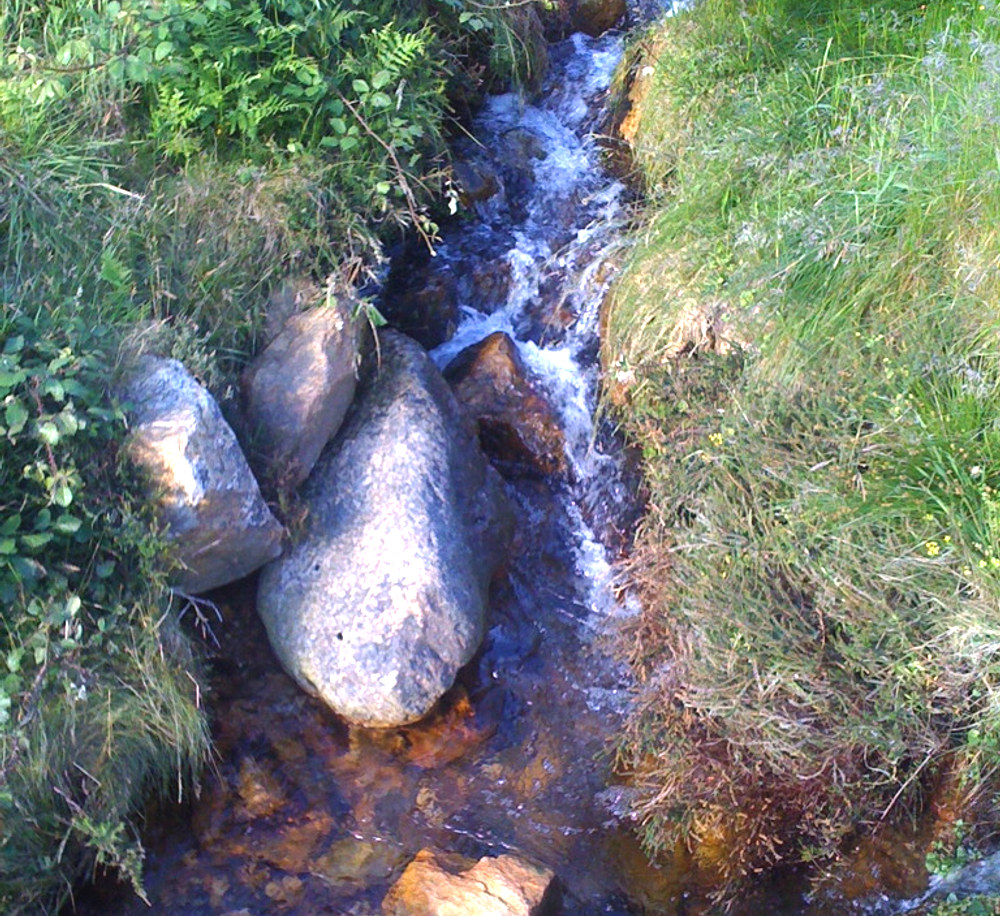
"O Pedregal de Irimia", nacimiento del Miño, es un enclave hidrográfico natural situado en la ladera oeste de la Sierra de Meira, a 3 kilómetros de la villa. "O Pedregal" es similar a un río de piedras, de unas piedras muy grandes organizadas de forma curiosamente natural, como un embudo. Su extensión es de aproximadamente 700 metros y al final de este embudo se aprecia un pequeño riachuelo de agua, del que se puede dar conocimiento si uno se sube a sus piedras y escucha con atención el murmullo del agua, ya que no se ve correr debido al taponamiento de las piedras. Este agua nace de numerosas fuentes repartidas a lo largo de toda la Sierra, y en concreto, una de ellas situada en alto del Pedregal, lugar donde el agua de todas ellas se junta, formando ya el comienzo del Miño que abastece de agua a Meira y a toda Galicia.
Durante mucho tiempo existió una gran polémica sobre si el nacimiento del Miño se encontraba en el Pedregal de Irimia o en la laguna de Fonmiñá, en el Ayuntamiento de A Pastoriza. Esta laguna es una afloración de aguas profundas, vinculada a procesos cársticos y / o hidrotermales que surge más abajo del nacimiento del Miño. Esta es la conclusión a la que llegaron expertos en hidrografía, después de introducir medidores para comprobar la profundidad de las fuentes y así concluyeron que, tanto la Sierra como el Valle de Meira, están situados sobre una gran balsa de agua y que, debido a esto, nace agua en diferentes puntos, uno de ellos, la laguna de Fonmiñá
Aguas subterráneas
El ciclo hidrológico comienza con la evaporación del agua de la superficie del océano. Cuando se eleva el aire húmedo, se enfría y el vapor de agua se condensa para formar nubes. La humedad se transporta alrededor del planeta hasta que vuelve a la superficie en forma de precipitaciónes. Una vez que el agua llega al suelo, uno de estos dos procesos pueden ocurrir;
1) una parte del agua puede evaporarse a la atmósfera
2) el agua puede penetrar en la superficie y se convierten en las aguas subterráneas.
Las aguas subterráneas son el agua encontrada bajo la superficie de tierra, contenida en los espacios dentro del suelo poroso y la roca. Las aguas subterráneas pueden ser obtenidas a partir de manantiales, perforaciones o pozos. Las rocas permeables tienen espacios diminutos entre las partículas de roca sólida, que permiten al agua y otros fluidos pasar y ser sostenida dentro de la estructura de la roca. Las rocas impermeables no tienen estos espacios y el agua no puede pasar por ellos.
Manantiales
Un manantial surge en el punto donde el límite entre una capa permeable de roca subterránea y una capa impermeable alcanza la superficie. El agua de lluvia se filtra por el suelo dentro de la parte permeable del subsuelo o de la roca subterránea. La filtración se detendrá si esta capa de subsuelo permeable se asienta sobre la cima de una capa impermeable y el agua no puede avanzar más. Dependiendo de la pendiente de las capas, el agua correrá a lo largo de la cima de la capa impermeable a un punto donde esta alcanza la superficie y surge como un manantial.
Condiciones favorables para la formación de manantiales:
Para registrar este earthcache, enviame un correo electrónico con las respuesstas para las siguientes preguntas:
1) ¿Cual es la orientación del manantial?
2) A la derecha del nacimiento, hay una roca de gran tamaño, la mayor. ¿Cuantas caras planas puedes contar? Dime su altura aproximada y su altura al suelo
3) ¿De donde piensa que procede el agua que alimenta el manantial?
4) Añade una fotografia tuya en el local, u otra en la que se pueda ver algún objeto, o tu nick en un papel
- Si piensa que a concluido con exito los objetivos de esta Earthcache y ya me envio todas las respuestas según lo pedido, por favor, proceda a logar el cache como encontrado, despues verificare las respuestas enviadas,y si es necesario, contactare con usted para efectuar las correcciones oportunas a su registro.
-Todos los logs sin respuestas seran apagados sin aviso.
English
"O Pedregal de Irimia", birth of the Miño river, is a natural hydrographic enclave located on the west slope of the Sierra de Meira, 3 kilometers from the village. "O Pedregal" is similar to a river of stones, of very big stones arranged of curiously natural form, like a funnel. Its extension is approximately 700 meters and at the end of this funnel you can see a small stream of water, from which you can know if one goes up to their stones and listen carefully the murmur of the water, since it is not seen to run due To the clogging of the stones. This water is born from numerous sources distributed along the whole Sierra, and in particular, one of them located in Pedregal high, place where the water of all of them joins, forming already the beginning of the Miño that supplies water to Meira And all of Galicia.
For a long time there was a great controversy about if the birth of the Minho was in the Pedregal of Irimia or in the lagoon of Fonmiñá, in the City council of A Pastoriza. This lagoon is an outcrop of deep water, linked to karstic and / or hydrothermal processes that arises below the birth of the Miño. This is the conclusion reached by experts in hydrography, after introducing meters to check the depth of the sources and thus concluded that both the Sierra and the Meira Valley are located on a large water raft and that, due to This, water is born in different points, one of them, the lagoon of Fonmiñát
Groundwater
The hydrologic cycle begins with the evaporation of water from the surface of the ocean. As moist air is lifted, it cools and water vapor condenses to form clouds. Moisture is transported around the globe until it returns to the surface as precipitation. Once the water reaches the ground, one of two processes may occur;
1) some of the water may evaporate back into the atmosphere
2) the water may penetrate the surface and become groundwater.
Groundwater is water found beneath the ground surface held in the spaces within porous soil and rock. Groundwater can be obtained from springs, boreholes or wells. Permeable rocks have tiny spaces between the solid rock particles that allow water and other fluids to pass through and be held within the rock structure. Impermeable rocks do not have these spaces and water cannot pass through them.
Springs
A spring occurs at the point where the boundary between a permeable layer of underground rock and an impermeable layer reaches the ground surface. Rainwater percolates through the soil into permeable layers of subsoil or underground rock. The downward percolation will be stopped if this layer sits on top of an impermeable layer and the water can go no further. Depending on the slope of the layers, the water will run along the top of the impermeable layer to a point where it reaches the surface and emerges as a spring
Favourable conditions for spring formation:
To log this earthcache, send me an email/message with the answer to the following questions:
1) What is the orientation of the spring? (S-N, E-O, etc)
2) Atthe right of the birth, there is a large rock, the largest. How many flat faces can you count? Tell me its approximate height and the height to the ground?
3) From where do you think that comes the water that feeds the spring
4) Add a photo of yourself at the place, or another in which you can see an object, or your nick on a piece of paper
-If you believe you have successfully completed this Earth Cache goals and has already sent to me all the requirements as requested, Please, feel free to log it as found. Later i will verify the requirements sent and, if necessary, contact you in order to make the necessary corrections to your log.
-Logs without answers, will be deleted without notice.