Ces Roches sont d’un grand intérêt géologique. Il s’agit de témoins du premier rivage marin qui, aux temps très anciens, bordait la terre ardennaise surgie de la mer il y a près d'un demi-milliard d'années.
Leur nom a été donné par la société « Les amis de l’Amblève » en hommage à Monsieur J.N. Crahay, Directeur général des Eaux et Forêts grâce à qui le site du Ninglinspo a été préservé et classé de manière définitive.
Ces roches sont situées à la crête d’un important massif de schiste situé entre la vallée de l'Amblève et le ravin du Ninglinspo.
Elles forment un belvédère naturel en lame de couteau d'une longueur d’environ 300m à une altitude de 280m, avec une orientation Nord-Sud.
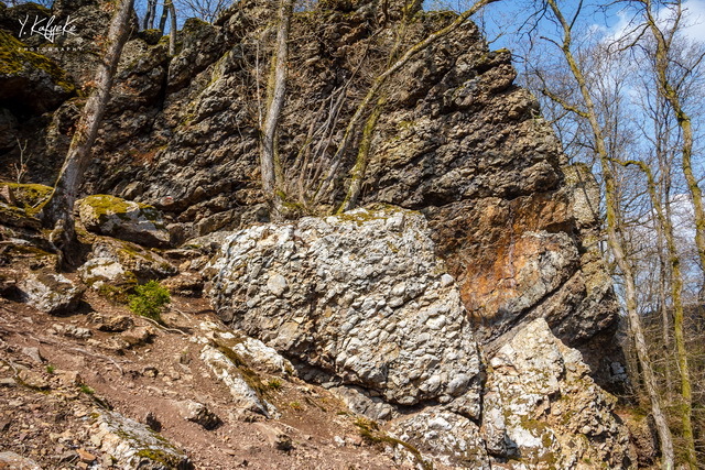
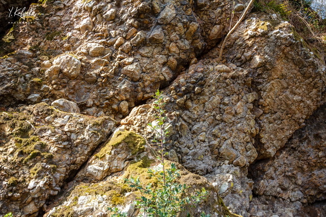
Elles sont composées d’énormes cailloux de quartzite et de schiste aux angles arrondis (galets) solidement réunis par un ciment naturel formant ainsi une sorte de béton (agglomérat) appelé "Poudingue".
Questions :
1. Selon vos observations, décrivez la roche en quelques mots (apparence et composition).
2. Comment expliquez-vous la présence de pierres arrondies, des galets, à cet endroit ?
Pour pouvoir loguer « Found it » :
Envoyez-nous vos réponses soit via notre profil, soit via la messagerie geocaching.com, et nous vous contacterons en cas de problème.
Si votre log ne contient pas de photos joignez une photo de vous sur le site à vos réponses.

About 4.5 billion years ago, the earth was shaped in a sphere of blocks of molten rock on the surface of which floated the lightest substances. Once cooled down, these materials solidified to form the terrestrial crust mainly made up of granite. When cooling, this crust thickens and reaches a temperature low enough to allow the vapours of the atmosphere to condense therein and therefore create the first seas. This cooling led to a decrease of the volume of the globe, which caused the creases on its surface to create mountains or large ponds which were invaded by the waters. The cliffs bordering the seas were subjected to the mechanical action of the waves, which caused rocks to be broken up (fragments), which, under the action of the ebb and flow, were divided and then blunted into pebbles, gravel and finer elements like sand and clay. The heaviest elements remain close to the cliff while the lighter ones are driven to the open sea. Therefore, we have the following distribution: pebbles near the shore, then gravel, sand and finally clay. In the course of time, other movements of the earth’s crust modified the level of the sea which continued to invade the land of the Ardennes. The same mechanism of erosion of the shores, led to the forming of new strata which settled on the old ones. Finally, the large stones were cemented by loose formations, and as a result of a great folding of the earth’s crust, this layer of stones consolidated by time was dislocated and straightened, as we can see it now. Given their nature (pudding) and their composition (quartzite and schist), these rocks are indeed the witnesses of the first shore of the Ardennes.
These rocks are of great geological interest. They are witnesses of the first marine shores which, in ancient times, bordered the land of the Ardennes sprung from the sea almost half a billion years ago. Their name was given by the company ‘Les Amis de l’Amblève’, a tribute to Mr J.N. Crahay, General Director of Eaux et Forêts, thanks to whom the Ninglinspo site has been preserved and classified definitively. These rocks are located at the crest of an important mass of schist located between the Amblève valley and the ravine of Ninglinspo. They form a natural belvedere in knife blade about 300 m long at an altitude of 280 m, with a North-South orientation. They are composed of enormous stones of quartzite and schist with rounded corners (pebbles) solidly joined by a natural cement forming a kind of concrete (agglomerate) called ‘pudding’.
Questions :
1. Depending on your observations, describe the rock in a few words (appearance and composition).
2. How do you explain the presence of rounded stone (pebbles), in this part?
Requirements for logging "Found it" :
Send us your answers via either our profile, or via geocaching.com, and we will contact you in case of problem.
If your log does not contain photos, attach a picture of yourself to your answers on the site.
Merci / Thank you / Danke @ Kersen22 🍒 pour le Beta testing 
Si vous avez trouvé les 2 EarthCache GC738NN et GC73A4H, vous pouvez afficher la bannière sur votre profil.
If you have found the 2 EarthCache GC738NN and GC73A4H, you can display the banner on your profile.
Code :
<a href="https://www.geocaching.com/geocache/GC738NN_ye-la-vallee-du-ninglinspo target="_blank"><img src="https://s3.amazonaws.com/gs-geo-images/00997578-b0db-4af5-b7f1-da913f11e5f8.jpg" title="La vallée du Ninglinspo/Roches Crahay" border="0" /></a>