DESCRIPTION:
Le Pont Roche, ou vieux pont de pierres, est un pont en pierres de taille enjambant la rivière Roxelane à l'extrémité nord de la rue Victor-Hugo à Saint-Pierre, en Martinique, et datant de 17661. C'est le plus vieux pont de la Martinique.
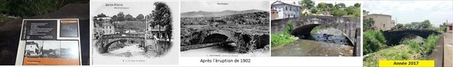
Le Pont Roche est construit en pierres de taille, chaux et sable. Il est long de dix mètres environ et fait d'une seule arche surbaissée. Il comporte une travée plate ainsi que des butées d'une remarquable épaisseur.
Le Pont Roche est inscrit à l'inventaire supplémentaire des monuments historiques par arrêté du 22 juillet 1980.
LE SITE :
La Roxelane, qui sépare le quartier historique du Fort de ceux du Centre et du Mouillage à Saint-Pierre, était initialement enjambée par un pont de bois unique, construit en 1642 par les Jésuites et leur permettant d'effectuer le trajet de leurs maisons de l'Habitation Perinelle, installée au nord de la cité, à leurs paroisses des quartiers sud. Ces derniers expulsés des Antilles en 1762, une ordonnance du gouverneur d’Ennery, prise le 18 novembre 1765, décide de la construction d'un nouveau pont de pierre remplaçant le pont de bois afin de faciliter les transports de la grande halle du port à la rive droite et relier ainsi le quartier du Mouillage à celui du Fort. Sa réalisation est confiée au frère de la Charité Cléophas Danton qui l'élève en 1766 avec la contribution financière volontaire des Pierrotins.
De part et d'autre de ce pont s'étire la très longue rue Royale N 1, qui traverse tout Saint-Pierre du nord au sud en reliant les quartiers du Fort et du Mouillage.
Son arche unique surbaissée qui enjambe la rivière Roxelane, où s'activent les blanchisseuses, devient vite au XVIIIe siècle l'un des lieux privilégié des messieurs et le point de passage obligé des ragots et des commentaires les plus moqueurs (les « milans »). Au siècle suivant, ses parapets de pierre sont aussi le rendez-vous habituel des conteurs et « sénateurs » autour desquels chaque soir, dès sept heures, des groupes se pressent pour commenter les événements du jour, puis écouter les histoires des conteurs. C'est aussi le lieu où s'affrontent pendant le carnaval les diables rouges du Fort et du Mouillage.
Le pont est construit si solidement qu'il est un des rares édifices à résister à l'éruption de la montagne Pelée en 1902 qui ravage Saint-Pierre, ne perdant que ses parapets de pierre. Avant l'éruption, on pouvait encore y lire sur le parapet du côté faisant face à la mer l'inscription suivante gravée sur une plaque de marbre : L'an MDCCLXVI du règne de Louis XV, ce pont a été construit sous le généralat du comte d'Ennery et l'intendance du président Thomassin de Peynier par les soins et sous la direction du frère Cléophas Danton, religieux de la Charité, qui a rendu ce service au public aux dépens des paroisses du Fort, du Mouillage et du Prêcheur. À droite et à gauche de l'inscription étaient gravés les écussons du comte d'Ennery et du président Louis de Thomassin de Peynier.
LA CACHE :
Une fois que vous avez trouvé une place pour votre voiture, le site est très facile d'accès. La cache de CAMO micro magnétique contient originellement le log, mais pas de crayon. Apportez donc votre crayon (BYOP) et soyez extrêmement discret, l’endroit est très fréquenté. SVP replacez la cache exactement à l’endroit où vous l’avez trouvé.

DESCRIPTION :
The Bridge Rock, or old stony bridge, is a stone bridge of size stepping over the river Roxelane in the north extremity of the street Victor-Hugo in Saint Pierre, in Martinique, and dating 17661. It is the oldest bridge of Martinique.
The Bridge Rock is built stone of size, lime and sand. He is ten meters long approximately and makes of a single lowered arc. He contains a flat span as well as abutments of a remarkable thickness.
The Bridge Rock is registered on the additional inventory of historic monuments by order of July 22nd, 1980.
THE SITE:
The Roxelane, which separates the historic district of the Fort of those of the Center and the Anchorage in Saint-Pierre, was initially stepped by a bridge of unique wood, built in 1642 by the Jesuits and allowing them to make the route of their houses of the House Perinelle, installed in the North of the city, in their parishes of the south districts. These last expelled of the Antilles in 1762, a prescription of the governor of Ennery, taken on November 18th, 1765, decides on the construction of a new stony bridge replacing the wooden bridge to facilitate the transport of the big hall of the port in the right bank and connect so the district of the Anchorage to that of the Fort. Its realization is confided to the brother of the Charity Cléophas Danton who raises It in 1766 with the voluntary financial contribution of the Pierrotins.
On both sides of this bridge stretches the very long street Royale N 1, which crosses all Saint-Pierre from north to south by connecting the districts of the Fort and the Anchorage.
Its lowered unique arc which steps over the river Roxelane, where bustle the laundresses, becomes fast in the XVIIIth century one of the places privileged person of the gentlemen and the grateful crossing point of the gossip and the most derisive comments (the "Milan). In the next century, Its stony rails are also the usual meeting of the storytellers and "the senators" around whom every evening, from seven hours, groups anticipates to comment on the day events, then listen to the stories of the storytellers. It is also the place where are in confrontation during the carnival the red devils of the Fort and the Anchorage.
The bridge is so solidly built as it is one of rare buildings to resist the eruption of the Mont Pelée in 1902 which ravages Saint-Pierre, losing only its stony rails. Before the eruption, we could again read to it on the rail of the side facing the sea the following registration engraved on a marble plate: the year MDCCLXVI of the reign of Louis XV, this bridge was built under the généralat of the count of Ennery and the estate management of the president Thomassin de Peynier by the care and supervised by brother Cléophas Danton, member of a religious order of the Charity, who returned this service to the public at the expense of the parishes of the Fort, the Anchorage and the Precheur. To the right and to the left of the registration were engraved the badges of the count of Ennery and the president Louis de Thomassin de Peynier.
THE CACHE :
When you found one place for your car, the site is very easily accessible. The cache magnétic Micro Size CAMO contains originally the log but no pencil. Thus bring your pencil ( BYOP) and be extremely discreet, the place is very busy. PLEASE replace the hiding place exactly in the place where you have found It.
---- Sources : Wikipédia.........