The legend of the moonrakers was that smugglers detected an approaching Exciseman (revenue agent) on a bright moonlit night. In order to waylay suspicion the smugglers dumped the contraband (usually barrels or kegs of French brandy) into a nearby pond. When the Exciseman had gone they began to fish out the barrels with hay rakes. However, the Exciseman came back and asked them what they were doing. They told him it was surely obvious, they were raking out the cheese they could see in the water. The Exciseman laughed at them for being so stupid and rode off. The "moonrakers" left off raking the moon, laughed at the Exciseman's naivety and continued to recover their kegs.
The stone was placed in June 2015 as part of the twinning weekend. It is a piece of Welsh Blue Pennant Sandstone.
Sandstone is a sedimentary rock. It was formed over millions of years, sediments of eroded rocks(sand) and skeletons of creatures carried by bodies of water and ice flows, deposited in lakes, rivers and on ocean floors. The sand particles blend with calcite or quarts and, with the compression, this compacts all these elements together to create Sandstone. All sand is not identical and comes in a variety of colors and textures, each formation has a unique appearance.
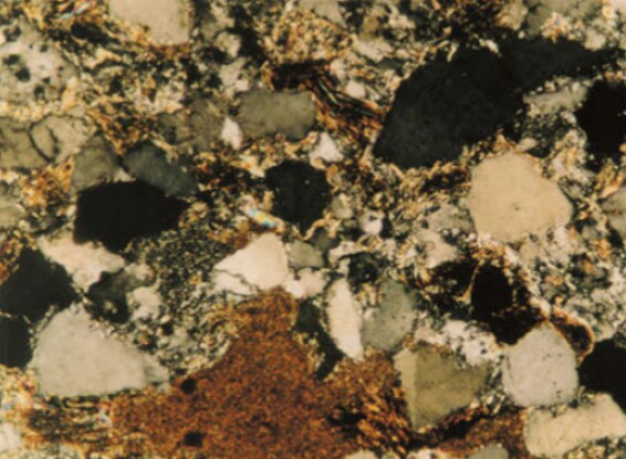
Blue Pennant Sandstone has a dark grey to blue/green colour and consists of quartz grains (grey/black) with a matrix of clay (bright particles) and carbonaceous matter (Brown particles )
The Pennant Measures is a sequence of sedimentary rocks of the South Wales Coalfield area. It is found in thick Beds, which range from 275m in the east of the coalfield up to 1350m in the Swansea area (a Bed is a distinct layer within a formation) which form a plateau of high ground along the tops of the valleys due to their hard resistant character. The word Pennant, which is probably of Welsh or Celtic origin, means head or top of the valley. The sandstones were deposited as part of a major fluvial channel system that once covered much of South Wales and parts of Gloucestershire.
The Pennant Sandstone was the main building stone in the South Wales and Bristol coalfield areas. It is most commonly seen in the terraced properties that can be found in the villages and towns in the steep valleys that dissect the coalfield areas.
To claim this EarthCache you must answer these questions, please send the answers by clicking on my name at the top of the page and using the message center or email link on my profile
1.Describe in detail the surface of the stone that faces the pavement
2.Examine the side of the stone do the layers run horizontally or vertically
3.As evidence that you have visited the stone please tell me the last 3 numbers of the phone number on the sign beside the stone. At the moment the sign is missing so I will accept the last 3 numbers from the blue bin (yes its a bit rubbish)
Purely optional ( not compulsory! ) take a photo of yourself or your gps at the smaller stone behind this one with the moonrakers legend plaque
Please do not post photos of the twinning stone in your logs