Z máp sa nedá určiť názov kopca a preto meno geo-skrýše je odvodené od anglického prekladu bezdrôtovej technológie. Ktorá je tiež využitá pri hľadaní tejto geo-skrýši.
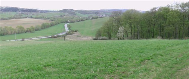
K lesu sa dá dostať jednou z troch ciest. Prvá je asi tá najjednoduchšia. Stačí zaparkovať auto pri ihrisku za školou v Šarišskej Porube a potom ísť severne po ceste až kým sa neocitnete na lúke na kopci, kde je pekný výhľad do údolia. Potom treba pokračovať k lesu smerom na východ. Alebo druhá možnosť je vyšlapať kopec z doliny. Dá sa to buď z autobusovej zástavky Nemcovce rázcestie (tam sa ale nedá zaparkovať auto). Odkiaľ je vyšlapaná cestička na Šarišskú Porubu, pričom je možné v určitom bode odbočiť z cesty smerom na juhovýchod k spomínanému lesu, kde je umiestnená skrýša. Posledná možnosť je zaparkovať auto na rozšírenej krajnici v zákrute pri obci Lipníky, ktorá je tiež naznačená na mape. Odtiaľ je to smerom na juh do lesa. Tam si treba dať pozor na močiar, ktorý sa tam v najnižšom mieste vytvára hlavne po daždi.
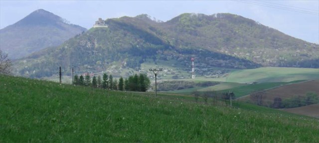
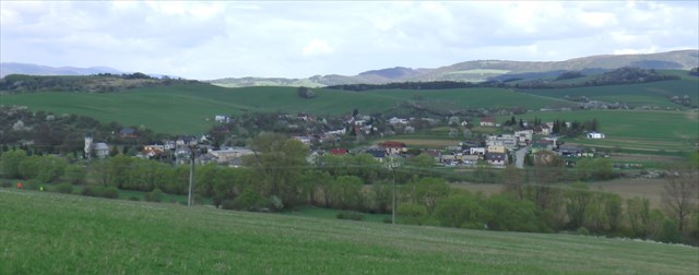
Z kopca je veľmi pekný výhľad na dolinu, kde sú obce Nemcovce a Lipníky. Rovnako dobrý výhľad je aj na Kapušiansky hradný kopec, ktorý je orientovaný západne. Najkrajší výhľad je pri západe slnka. V doline tečie aj rieka Ladianka (v šarišskom nárečí tiež nazývaná Ladzinka).
Prečo teda táto geo-skrýša dostala názov podľa bezdrôtovej technológie? Jednoducho preto aby Vám pomohla lokalizovať jej presnú polohu nezávisle od GPS súradníc. Pri geo-skrýši je totiž umiestnený maják, ktorý vysiela veľmi slabý rádiový signál do éteru každých 8 sekúnd. Signál je tak slabý, že jeho dosah od skrýše je tak akurát po okraj lesa. Ak si chcete lokalizáciu vyskúšať podľa signálu z tohto majáku s technologiou Modrý Zub, potrebujete k tomu smartphone alebo tablet s Androidom. Na detekciu signálu je potrebné si nainštalovať aplikáciu s názvom "Modrý Zub Beacon Scanner". Aplikácia je zdarma a nie je určená na komerčné použitie, rovnako tak neobsahuje žiadne reklamy. Jej cieľom je vyhľadávanie majákov v teréne. Aplikáciu nájdete v Google Play, ale treba si vyfiltrovať iba aplikácie a kategóriu nástroje. Po spustení aplikácie je na displeji zobrazený kruh na čiernom pozadí. Zachytávanie signálu majáku sa aktivuje po kliknutí na tlačidlo START SCAN. Ak aplikácia nezachytí žiaden signál, tak kruh nie je vôbec zobrazený. Naopak ak aplikácia zachytí signál z majáku, tak sa kruh začne zobrazovať a jeho veľkosť a farba sa mení podľa sily signálu. Takto je možné určiť, či sa od geo-skrýše vzďaľujete alebo sa k nej približujete. Signál majáku obsahuje správu. Obsah sa dozviete po zachytení signálu.
Skrýšu nájdete samozrejme aj bez použitia technológie modrý zub. Tento nápad použiť túto technológiu pri mojej prvej geo-skrýši som dostal najmä preto, lebo to dosť uľahčí jej dohľadanie a ušetrí to frustráciu, ak nie je možné v niektorých prípadoch za sťažených podmienok geo-skrýšu nájsť. Tu sa odvolávam hlavne na cudzie geo-skrýše u niektorých som bol veľmi frustrovaný :) . Týmto ale samozrejme nie je mojím cieľom všade dávať maják k cudzím geo-skrýšam (iba po dohode s tvorcom geo-skrýše). Každopádne budú ho obsahovať všetky moje geo-skrýše v budúcnosti, čím chcem uľachčiť dohľadanie skrýše ostatným. Ešte jedno upozornenie, maják nie je súčasťou geo-skrýše, ale je umiestnený v okruhu niekoľkých metrov od nej vzdialený, aby skrýša bola naďalej skrýšou :)
Veľa štastia pri hľadaní geo-skrýše.
Location of geocache is in the leafy woods east of the hill on top of which is located a village Šarišská Poruba. From the hill is a nice view of the valley in which the river Ladianka and villages Nemcovce and Lipníky are there. On the west side you can see the castle of Kapušany. From the maps can not be determined the name of the hill and therefore geo-caches name is derived from the English translation of wireless technology. Which is also used in this geocache.
The forest can be reached by one of three ways. The first is probably the easiest. Just park your car at the playground behind the school in Saris Poruba and then go north along the road until you find yourself in a meadow on a hill where there is a nice view of the valley. Then need to go to the forest to the east. Or the other option is to hike up the hill from the valley. This can be done either from the bus stop Nemcovce crossroads (there is but can not park your car). Where it is path to Šarišská Poruba, where it is possible at some point, turn off the road to the southeast to the forest, where there is a geocache. The last option is to park your car on the roadside of the enlarged curve near the village Lipníky, which is also shown on the map. From there it southward into the forest. There can be aware of the marsh, which is there at the lowest point creates especially after rain.
Downhill is a very nice view of the valley where the village Nemcovce and Lipníky are. Equally good view is also Kapušiansky castle hill, which is oriented to the west. The best view is at sunset. In the valley flows the river Ladianka (in Šariš dialects also called Ladzinka).
Why would this geo-stash was named by wireless technology? Simply because to help you locate the exact position regardless of GPS coordinates. The geo-located because the beacon, which emits a very low radio signal on the air every 8 seconds. The signal is so weak that it can be detected just right to the edge of the forest. If you want to try by locating signal from the beacon with blue tooth technology, you need a smartphone or Android tablet. For signal detection, it is necessary to install the application called "Modrý Zub Beacon Scanner". The application is free and is not intended for commercial use, as well as contains no ads. Its aim is to search beacons on the ground. Application is in the Google Play, but you need to filter out applications and tools category. After launching the application, it displays a circle on a black background. Detecting of signal beacon is activated when you click on button Start Scan. If the application does not catch any signal, then circle it is not displayed. On the contrary, if the application detects the signal from the beacon then it displays the circle with size and the color changed according to the signal strength. Thus, it is possible to determine whether the geo-caches is near or far from you. Beacon signal contains the message. The contents of message you can read after the detecting of signal from beacon.
Geocache can be found naturally without using blue tooth technology. The idea to use this technology in my first geocache I got especially because it facilitates quite a finding of frustration and save it if it is not possible in some cases, under difficult conditions, geo-locate stash. Here I refer primarily to foreign geo-caches in some I was very frustrated :). But of course this is not my goal everywhere placing beacons for foreign geochaches (only in agreement with the creator of geocache). Anyway, it will contain all my geocaches in the future, so I want to make it easier to find them. One more warning beacon is not part of geocache, but it is located within a few meters away from it, to stash remained hiding place :)
Good luck in finding geocaches.
Some photos