In oceanography, geomorphology, and earth sciences, a shoal is a natural submerged ridge, bank, or bar that consists of, or is covered by, sand or other unconsolidated material, and rises from the bed of a body of water to near the surface. Often it refers to those submerged ridges, banks, or bars that rise near enough to the surface of a body of water as to constitute a danger to navigation. Shoals are also known as sandbanks, sandbars, or gravelbars. Two or more shoals that are either separated by shared troughs or interconnected by past and or present sedimentary and hydrographic processes are referred to as a shoal complex.
Sandbar

The term shoal is also used in a number of ways that can be either similar or quite different from how it is used in the geologic, geomorphic, and oceanographic literature. Sometimes, this terms refers to either (1) any relatively shallow place in a stream, lake, sea, or other body of water; (2) a rocky area on the sea floor within an area mapped for navigation purposes; (3) a growth of vegetation on the bottom of a deep lake that occurs at any depth; (4) and as a verb for the process of proceeding from a greater to a lesser depth of water.
Shoals are characteristically long and narrow (linear) ridges. They can develop where a stream, river, or ocean current promotes deposition of sediment and granular material, resulting in localized shallowing (shoaling) of the water. Marine shoals also develop either by the in place drowning of barrier islands as the result of episodic sea level rise or by the erosion and submergence of inactive delta lobes. Shoals can appear as a coastal landform in the sea, where they are classified as a type of ocean bank, or as fluvial landforms in rivers, streams, and lakes. A shoal–sandbar may seasonally separate a smaller body of water from the sea, such as: Marine lagoons Brackish water estuaries Freshwater seasonal stream and river mouths and deltas. The term bar can apply to landform features spanning a considerable range in size, from a length of a few metres in a small stream to marine depositions stretching for hundreds of kilometers along a coastline, often called barrier islands.
They are typically composed of sand, although they could be of any granular matter that the moving water has access to and is capable of shifting around (for example, soil, silt, gravel, cobble, shingle, or even boulders). The grain size of the material comprising a bar is related to the size of the waves or the strength of the currents moving the material, but the availability of material to be worked by waves and currents is also important.
Wave shoaling is the process when surface waves move towards shallow water, such as a beach, they slow down, their wave height increases and the distance between waves decreases. This behavior is called shoaling, and the waves are said to shoal. The waves may or may not build to the point where they break, depending on how large they were to begin with, and how steep the slope of the beach is. In particular, waves shoal as they pass over submerged sandbanks or reefs. This can be treacherous for boats and ships. Shoaling can also diffract waves, so the waves change direction. For example, if waves pass over a sloping bank which is shallower at one end than the other, then the shoaling effect will result in the waves slowing more at the shallow end. Thus the wave fronts will refract, changing direction like light passing through a prism. Refraction also occurs as waves move towards a beach if the waves come in at an angle to the beach, or if the beach slopes more gradually at one end than the other.
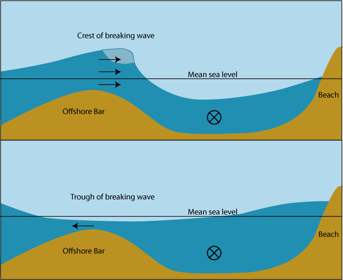
Sandbars, also known as a trough bars, form where the waves are breaking, because the breaking waves set up a shoreward current with a compensating counter-current along the bottom. Sometimes this occurs seaward of a trough (marine landform). Sand carried by the offshore moving bottom current is deposited where the current reaches the wave break. Other longshore bars may lie further offshore, representing the break point of even larger waves, or the break point at low tide.
Longshore Bar

In addition to longshore bars discussed above that are relatively small features of a beach, the term shoal can be applied to larger geological units that form off a coastline as part of the process of coastal erosion. These include spits and baymouth bars that form across the front of embayments and rias. A tombolo is a bar that forms an isthmus between an island or offshore rock and a mainland shore. In places of re-entrance along a coastline (such as inlets, coves, rias, and bays), sediments carried by a longshore current will fall out where the current dissipates, forming a spit. An area of water isolated behind a large bar is called a lagoon. Over time, lagoons may silt up, becoming salt marshes. In some cases, shoals may be precursors to beach expansion and dunes formation, providing a source of windblown sediment to augment such beach or dunes landforms.
In order to log this Earthcache, you must email Caching Conductor the answers to the following questions, within 30 days or your log will be deleted.
1. What type of material is the ground composed of, sand or granular material?
2. At the posted Cords the depth is about four feet. Based on what you've learned from this page do you think the depth would remain similar up to the shore or get deeper before the shore?
-OPTIONAL- Post a photo of your team and/or your GPSr from a boat or the water with the island in the background. You may post this photo with your log.
