Español
Localización
El río Mao, situado en el ayuntamiento de Lobios, deja a su paso numerosos lugares de esparcimiento que se convierten cada año en la opción de baño veraniego de los vecinos. Una de esas alternativas se encuentra en Cela. Aquí, el río Mao, baja desde el alto del Xurés para moldear las Pozas das Olas, un bonito espacio natural con cañones, pozas y saltos de agua.
Geomorfologia
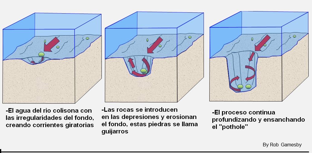
Los "potholes" son agujeros cilíndricos perforados en el lecho de un río que varían en profundidad, diámetro desde unos pocos centímetros hasta varios metros. Se encuentran en el curso superior de un río donde tiene suficiente energía potencial de erosionar verticalmente y su flujo es turbulento. En el curso superior de un río, su carga es grande y se transporta principalmente por tracción a lo largo del lecho del río. Cuando el agua fluye y encuentra de objetos en el fonfo, este es forzado a pasar sobre él y se forman corrientes descendentes detrás de la carga de fondo en remolinos de corrientes cortantes. Estas corrientes erosionan el lecho del río y crean pequeñas depresiones en ella.
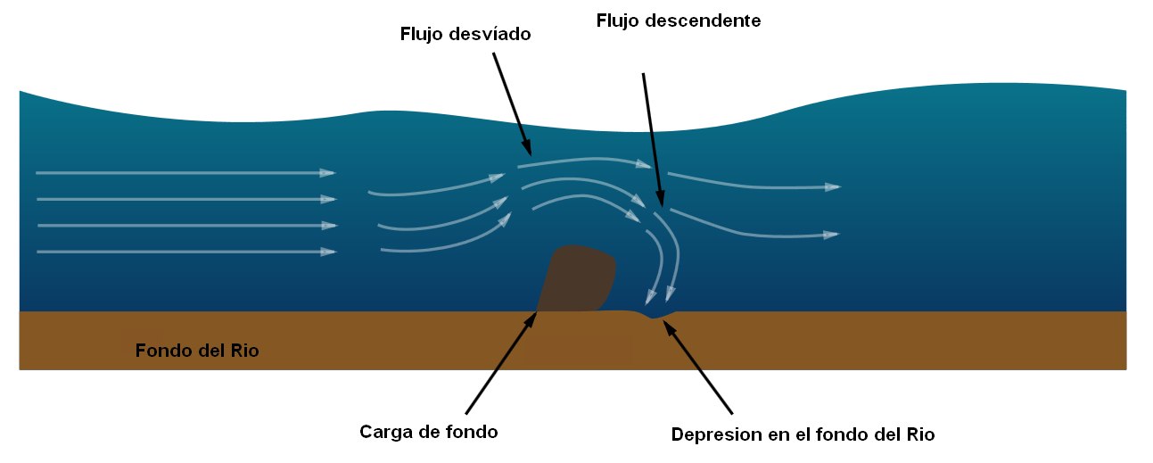
A medida que estas depresiones se profundizan, los guijarros pueden quedar atrapados en ellos. Como resultado de las corrientes giratorias, los guijarros comienzan a taladar en las depresiones haciéndolos más circulares, más anchos y más profundos. Los guijarros sólo serán capaces de erosionar el lecho de un río, si la roca de los guijarros esta formada de un material más fuerte que la roca del lecho del río
Para registrar este earthcache, enviame um correoeletrónico com la respuesta a las seguintes preguntas:
1) ¿Cual es el primer origen de los "potholes"? ¿En que parte del rio se suelen formar y porque?
2) En las coordendas dadas hay un "pothole" de algo menos de un metro, ¿Seguira aumentando su tamaño?¿Porque? Dame su profundidad estimada
3) Unos 70 metros rio abajo puedes encontrar la poza de mayor tamaño, por encima de esta hay varias de mucho menor tamaño. Dime cuantas puedes ver por encima de la mayor
-Si crees que as concluido con exito los objetivos de este Earth Cache, y me ha enviado todas las respuestas solicitadas, puede hacer el log. Luego yo comprobaré que son correctas, y si hay cualquier problema me pondre en contacto para arreglarlo.
-Logs sin respuestas enviadas previamente, seran borrados sin aviso
-Las fotos son opcionales, pero se agradecen y ayudan a verificar la visita
English.(google translate)
Location
River Mao, located in the town hall of Lobios, leaves in its way numerous places of entertainment that become each year in the option of summer bathing of the neighbors. One such alternative is found in Cela. Here, the Mao River, descends from the top of the Xurés to shape the Pozas das Olas, a beautiful natural space with canyons, pools and waterfalls.
Geomorphology
Potholes are cylindrical holes drilled into the bed of a river that vary in depth, diameter from a few centimetres to several metres. They’re found in the upper course of a river where it has enough potential energy to erode vertically and its flow is turbulent. In the upper course of a river, its load is large and mainly transported by traction along the river bed. When flowing water encounters bedload, it is forced over it and downcuts behind the bedload in swirling eddie currents. These currents erode the river’s bed and create small depressions in it.
As these depressions deepen, pebbles can become trapped in them. As a result of the eddie currents, the pebbles drill into the depressions making them more circular, wider & deeper. Pebbles will only be able to erode a river’s bed though if the rock the pebble’s made of is stronger than the rock the river bed is made of.

To log this earthcache, send me an email /message with the answer to the following questions:
1) What it is the first origin of the potholes? What part of the river are they often formed and why?
2) In the given coordinates there is a "pothole" smaller than one meter, Will it continue to increase its size? Give me your estimated depth
3) About 70 meters downstream you can find the largest pond, above this there are several much smaller. Tell me how many can you see above the greater one
-If you believe you have successfully completed this Earth Cache goals and has already sent to me all the requirements as requested, Please, feel free to log it as found. Later i will verify the requirements sent and, if necessary, contact you in order to make the necessary corrections to your log.
-Logs without answers, will be deleted without notice.
-Pictures are optional, but they are welcome and will be usefull to verify you visit