DE: Gutes Schuhwerk ist Voraussetzung und viel Interesse für die Natur. Ich habe auf der Wanderung nicht nur Steine und Pflazen gesehen, sondern auch Feuersalamder und andere seltenen Tiere.
Man kann und sollte die Wanderung fortführen bis Sveti Duh in Slowenien. Der Weg bis Sveti Duh is ca 2,5 Stunden der ganze Rundgang 5 Stunden.
EN: Good hiking shoes are mandatory and a lot of interest into nature. While I hiked there not only did I see stones and plants but also rare animals like fire salamanders.
You can continue the hike until Sveti Duh in Slovenia. one way is 2,5 hours. The round tour is about 5 hours.
DE: Die Erosion ist ein grundlegender Prozess im Gesteinskreislaufes. Er beinhaltet die Abtragung von mehr oder weniger stark verwitterten Gesteinen oder Lockersedimenten einschließlich der Böden. So erschafft die Erosion einerseits Geländeformen wie Berg und Tal, zerstört selbige jedoch schließlich bei anhaltendem Wirken vollständig. Bei Erosion wird im Wesentlichen zwischen linienhafter und flächenhafter Erosion unterschieden. Unter linienhafter Erosion versteht man die Eintiefung der Erdoberfläche durch abfließendes Wasser in kleinen, kurzlebigen Rinnsalen (Rillenerosion) oder in Fließgewässern (dann als fluviale oder Flusserosion bezeichnet). Eine andere und derzeit auf der Erde weniger weit verbreitete Form linienhafter Erosion erfolgt durch Gebirgsgletscher. Die entstehenden Talformen sind V-förmig (Kerbtal) bei fluvialer und U-förmig (Trogtal) bei glazialer Erosion. Hingegen erfolgt flächenhafte Erosion äolisch (durch Wind), marin (durch Meeresbrandung und -Strömung), glazial durch Inlandeis und gelegentlich auch direkt durch Niederschläge. Lineare und flächenhafte Erosion sind nicht vollständig voneinander abgrenzbar und maßstabsabhängig. So wirkt Rillenerosion im kleinen Maßstab linienhaft, im großen Maßstab jedoch flächenhaft (insbesondere z. B. bei Bodenerosion). Die großflächige Abtragung und Einebnung ganzer Landoberflächen wird als Denudation bezeichnet.
EN: Erosion is a fundamental process in the rock cycle. It involves the removal of more or less heavily weathered rocks or loose sediments, including the soils. Thus the erosion on the one hand creates terrain forms like mountain and valley, but completely destroys the same in the course of continuing activity. In erosion, a distinction is made between linear and extensive erosion. By linear erosion we mean the deepening of the earth's surface by discharging water in small, short-lived streams (rill erosion) or in streams (then referred to as fluvial or river erosion). Another form of linear erosion, which is currently less widespread on Earth, occurs through mountain glaciers. The resulting valley forms are V-shaped with fluvial and U-shaped with glacial erosion. Extensive erosion on the other hand is aeolian (by wind), marin (by sea fires and streams), glacial by inland ice and occasionally also directly by rainfall. Linear and extensive erosion can not be completely separated from one another and depend on the scale. Thus, small-scale erosion occurs linearly, but on a large scale it is extensive (particularly in soil erosion). The large area abrasion and leveling of whole land surfaces is called denudation.
DE: Dieser Earthcache soll um die verschiedenen Formen und Ausprägungen der fluvialen Erosion gehen. In kleiner Ausprägung lassen sich viele fluviale Erosionsformen in der Heiliggeistklamm entdecken.
EN: This Earthcache shall be about the different shapes and characteristics of fluvial erosion. In small scale many forms of fluvial erosion can be discovered in the Heiliggeistklamm.
fluviale Erosion / fluvial erosion:
DE: bezeichnet die Erosion, Partikelaufnahme und -verlagerung (fluvialer Transport) durch das fließende Wasser sowie Korrasion durch mitgeführte Feststoffe. Die Intensität der fluvialen Erosion wird bestimmt durch Abflußmenge, Sohlengefälle, Fließgeschwindigkeit, mitgeführte Flußfracht und Abtragungsresistenz des Gesteins.
EN: Refers to the erosion, particle intake and displacement (fluvial transport) by the flowing water, as well as corrasion by the accompanying solids. The intensity of the fluvial erosion is determined by the flow rate, the sediment gradient, the flow velocity, the accompanying flux and the resistance to erosion of the rock.
Korrasion durch Wasser / Corrasion by water:
DE: In Fließgewässern bezeichnet der Begriff die Zerkleinerung von mitgeführtem Geröll sowie die damit einhergehende Abtragung von den Wänden in Höhlensystemen.
EN: In river waters, the term means the comminution of entrained debris as well as the associated removal of the walls from cave systems.
DE: Folgende Erosionsformen können in der Heiliggeistklamm gefunden werden
EN: following erosion characteristics can be found in the Heiliggeistklamm:
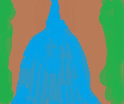
a) Wasserfall / Waterfall:
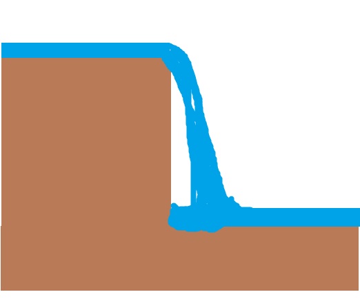
DE: Ein Wasserfall ist ein Abschnitt eines Fließgewässers an dem die Strömung, bedingt durch die Formung des Gesteinsuntergrundes, mindestens teilweise in freien Fall übergeht.
EN: A waterfall is a section of a stream where the flow, at least partly due to the formation of the rock underground, passes in free fall (or nearly at least).
|
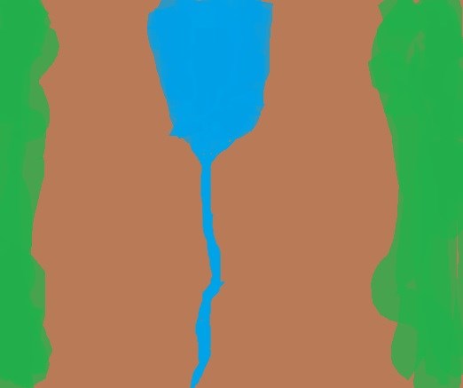
b) Kaskade / Cascade:
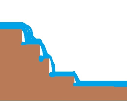
DE: Eine Kaskade (von italienisch cascare „fallen“) ist allgemein ein Wasserfall, im engeren Sinne einer, der über mehrere Stufen fällt.
EN: A cascade (from Italian cascare "fall") is generally a waterfall, in the narrow sense one, which falls over several stages.
|
c) Gumpen / Plunge pools:
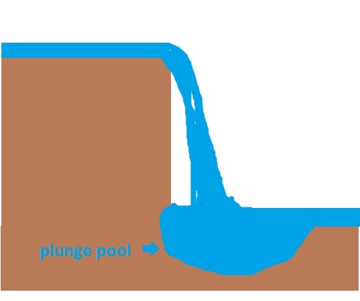
DE: „Als Gumpen werden überwiegend beckenartige Strudeltöpfe bezeichnet, die von Sturzbächen in den felsigen Untergrund eines Bachbetts erodiert werden.“
https://de.wikipedia.org/wiki/Gumpe
EN: a plunge pool is a deep depression in a stream bed at the base of a waterfall. It is created by the erosional forces of falling water on the rocks at fall's base where the water impacts.
|
d) Sammelbecken von Schotter und Geröll / collection pools of gravel and pebbles:
DE: Sie sind flache Stellen im Bach, die wie Gumpen geformt sind, allerdings ohne den zugehörigen Wasserfall. Diese Becken sind gefüllt mit Schotter und Geröll.
EN: are flat spots in the stream, which are shaped like kolks, but without the corresponding waterfall. These basins are filled with gravel and pebbles.
|
e) Staudämme / dams:
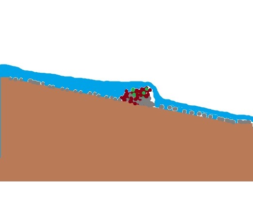
DE: Durch hängenbleiben von Baumstämmen und anderen Pflanzenteilen an Felsen entstehen Dämme, die den Bach stauen. Das kann sogar dazu führen, dass der Bach sich einen anderen Verlauf suchen muss und dadurch Altarme entstehen.
EN:By blocking tree trunks and other parts on rocks, dams are built. This can even lead to the fact that the stream has to form a different course and thus create oxbow lake.
|
f) Altarm / oxbow lake:
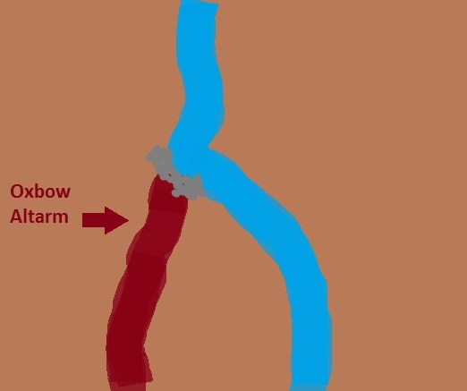
DE: „Ein Altarm ist der Teil eines Flusses, der durch natürliche (Sand- oder Kiesbank) oder künstliche (Absperrdamm) Einwirkung an einem Ende vom Hauptstrom abgeschnitten ist. Altarme entstehen häufig aus Nebenarmen. Da sie nicht mehr durchströmt sind, neigen sie zur Versumpfung oder gar Verlandung.“
https://de.wikipedia.org/wiki/Altwasser_(Fluss)
EN: An oxbow lake is the part of a river that is cut off by natural (sand or gravel bank) or artificial barrier at one end from the main stream. Oxbow lakes arise often from sidearms. Since they are no longer connected, they tend to become muddy or even sediment.
|
g) Glattpolierte Flächen (Wasserrutsche) / slides:
DE: Eine Gesteinsfläche ist vom Wasser durch die mitgeführten Schotter und Gesteinsbrocken glatt poliert. Das glattpolierte Gestein muss wesentlich härter sein als die mitgeführten „Schleifpartikel“ damit keine tiefen Rillen entstehen. Durch die breite gleichmäßig überflossene Fläche ist das Gestein auch gleichmäßig flach.
EN: A rocky surface is smoothly polished by the water through the gravel and rock fragments carried along. The smoothly polished rock must be considerably harder than the "abrasive particles" which are carried along so no deep grooves are formed. Due to the wide uniformly overflowing surface, the rock is evenly flat.
|
h) Wasserrillen in glattpolierten Flächen / water grooves:
DE: Wenn in einer Wasserrutsche das Wasser nicht flächig sondern zu großen Teilen nur über eine bestimmte Fläche fließt entsteht dort eine Fließrille, die sich über die Zeit vertieft und damit mehr Wasser dort gesammelt durchfließt und den Effekt verstärkt. Trotzdem ist das Gestein so widerstandsfähig, dass es nicht bricht oder als Schotter erodiert, sondern immer noch eine glattpolierte Fläche entsteht.
EN: If a water slide is not overflow by water in a large area but only on a certain area, a small groove is formed which deepens over time, thus collecting more water and enhancing the effect. Nevertheless, the rock is so resistant that it does not break or erode as a gravel and still a smooth polished surface is produced.
|
Sources:
wikipedia.org
spektrum.de
Logging
DE: Um den Earthcache erfolgreich zu loggen schickt mir über mein Profil bitte folgende Informationen:
-
Wie oft musstest Du den Hauptstrom der Heiliggeistklamm während der Wanderung von Startpunkt bis zum Zielpunkt überquert werden? Glaubst Du, dass diese Anzahl sich in den kommenden Jahren verändern wird? Begründe Deine Antwort.
-
Im Listing sind mehrere fluviale Erosionen aufgelistet. Finde zwei davon in der Klamm und ermittle die Koordinaten. Schicke mir die Koordinaten mit der Beschreibung der Erosionsform.
-
Ist das Tal der Heiliggeistklamm glazialen oder fluvialem Ursprungs?
-
Am Wegpunkt 2 findest Du eine Klippe. Was glaubst Du, ist sie durch den Bach entstanden oder nicht? Bitte begründe Deine Antwort.
Über ein freiwilliges Foto würde ich mich freuen. Es dürfen auch Fotos der Erosionsformen sein, allerdings ohne die Koordinaten.
EN: To successfully log the Earthcache please send me the following information via my profile:
-
How often did you need to cross the main stream of the Heiliggeistklamm during the hike from the starting point to the destination? Do you think this number will be constant in the coming years? Why do you think so?
-
The listing lists several fluvial erosions. Find two of them in the Heiliggeistklamm and determine the coordinates. Send me the coordinates with the description of the erosion form.
-
Is the valley of the Heiliggeistklamm of fluvial or glacial origin?
-
At Waypoint 2 you'll find a cliff. What do you think, did the stream form it or not? Why do you think so?
I would be happy about a voluntary photo. These may also be photographs of the erosion forms, but without the coordinates, of course.
DE: Schickt die Antworten über mein Profil. Ihr braucht nicht auf eine Logerlaubnis warten. Sollte etwas nicht stimmen melde ich mich bei Euch.
Logs ohne zugehörige Mail/Message werden gelöscht.
Logs, die die Antworten auf die Fragen enthalten werden ebenfalls gelöscht.
EN: Send answer through GC profile. You do not have to wait for an additional permission to log the Eartcache. I will only contact you if something is wrong.
Logs without an accompanying e-mail / message will be deleted.
Logs containing the answers will also be deleted.