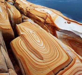
(Bands In Sandstone)
Liesegang bands (also called Liesegang rings) are colored bands seen in sedimentary rocks that typically cut-across bedding planes. These secondary sedimentary structures exhibit bands of minerals that are arranged in a regular repeating pattern. Liesegang rings are distinguishable from other sedimentary structures by their concentric or ring-like appearance. The precise process from which Liesegang rings form is not entirely known and is still being researched. Liesegang rings possibly form from the chemical seperation of minerals during the weathering process.
Liesegang rings are considered a frequent occurrence in sedimentary rocks, like those seen in the sandstones around Sedona. These rings, composed of iron oxide, also occur in permeable igneous and metamorphic rocks that have been chemically weathered. At this location the rings are located in granite, an igneous rock. Note that the concentration of iron oxide discoloration tends to be along fractures.....sites of increased groundwater flow.
Observations for both sites will be from the posted coordinates. Do not leave the trail. Site #1 is close enough to see easily. Site #2 is at a distance of 1000 feet on a course of 231 degrees, an area below the vertical cliff face. Email your answers to the questions, to me, by clicking on my name above. If your answers are not received by me, your log will be deleted. Photos are accepted and appreciated as long as the answers are not pictured. You do not have to wait for confirmation from me before logging this cache as completed. Most of all……learn……and enjoy the view.
Site #1
1. Are joints or cracks visible within the bands?
2. How wide are the bands at their widest point?
3. What color are the bands?
4. Are the bands horizontal, vertical, angular, circular, random, patterned?
5. How many bands are in the rock in question?
Site #2
1. Are the bands horizontal, vertical, angular, circular, random, patterned?
2. Estimate how many bands there are just below the vertical lichen covered (green/yellow) cliff face near the top of the mound?

The cache is on Arizona State Trust Land. A Recreational Permit is required ($15 individual, $20 family). These permits are valid for one year from the date of purchase and can be obtained through the mail by calling (602)364-2753, or by visiting the Arizona State Land Department, 1616 W. Adams Street, Phoenix, AZ 85007. You can also download the application from the ASLD web site.