Rivers that flow in gently sloping land tend to wander left to right making curves in the channel known as "meanders".
Meandering rivers occur when a river flows along a fairly flat or gentle slope. The constant flow of water, in particular during seasonal flooding or after a rain event can erode the banks where the water is flowing fastest, along outer bank. Sand and debris is carried downstream and is deposited along the inside banks where the water flow is slowest. The inside part of the curve is almost always the shallowest while the outside of the curve is deepest. Gravel bars can also form creating small islands typically along the inside curve of a meander, frequently found in much wider rivers like the Grand River or the Thames River.

Over time, meanders get larger and more pronounced as the outer edge has more material deposited on it. Given enough time, the meanders can curve enough so that they bend back sharply and can touch itself, creating an Oxbow Lake. Eventually, the neck will connect and the water will flow through the shorter course while the oxbow lake will be left out of the loop so to speak. Eventually it will be cut off from the main river which will take the straighter path.
Meander forming into an Oxbow Lake

Oxbow Lake Formation Animation
Types of Erosion by Water:
- Splash Erosion: Small soil particles are detached and sent airborne through the impact of raindrops on soil.
- Sheet Erosion: Raindrops break apart the soil structure and it's moved downslope by water that flows overland as a sheet rather than definitive channels. This occurs frequently during cloud bursts.
- Rill Erosion: This process develops small, short-lived, concentrated flow paths. These paths creates a sediment source and delivery system for hillslope erosion. Areas where precipitation rates exceed soil infiltration rates are more prone to this type of erosion.
- Gully Erosion: Water flows in narrow channels during or directly following heavy rains or melting snow. The gullies can erode to considerable depths.
- Valley or Stream Erosion: Continual water flow alongside land (along a linear feature) creates this type of erosion. It extends downward, deepening a valley, and headward, extending the valley into the hillside. This occurs most frequently in times of flooding.
- Streambank Erosion: Over time, banks of rivers and streams are naturally worn down.
Water flow and its effect on erosion and deposition
Water flow is an important mechanism for both erosion and deposition. The flow of water is controlled by both the streams gradient and by the geometry of the stream channel.
Where a stream is narrow, the water flow velocity will be greater. Water flow velocity is decreased by friction along the stream bed, with the slowest flow at the bottom and along the edges and fastest flow just below the water surface.
Fun fact: velocity just below the surface is typically a little higher than right at the surface because of friction between the water and air.
On a curved section of a stream, flow is fastest on the outside and slowest on the inside. The gradient along the edge of a stream will also affect the flow rate, with the fastest flow where the bank is steepest and the slowest flow where the bank slopes gently down.

Other factors that affect stream water velocity are the size of sediments on the stream bed, as large particles will tend to slow the flow more than small ones. During a flood, the water level will rise so there is more cross sectional area for the water to flow in. If the river remains confined to a channel, the velocity of the water flow will increase but if the river tops its banks the water flow will decrease as there is more surface area for the water to move along.
Erosion prevention
There are a number of methods that municipalities can use stabilize banks and shoreline, from hard engineering techniques to simple restoration of natural vegetation. All of these methods are intended to protect water quality and in some cases preserve the integrity of the shoreline and safety of people and wild life.
Hard Engineering techniques
These techniques can be more expensive however have the advantage that they are more permanent and last longer so can be more cost effective where shoreline erosion is a concern. They include”
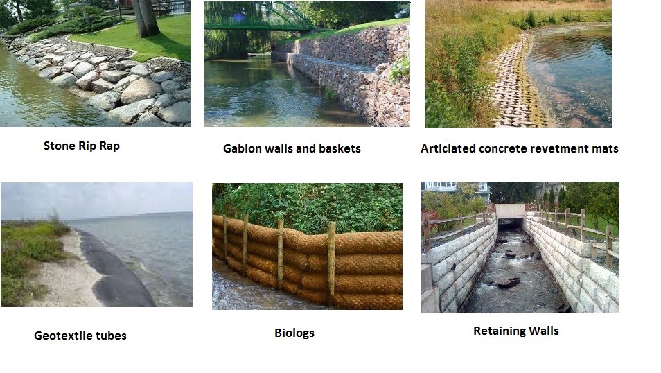
- Retaining walls
- Stone riprap
- Gabion walls and baskets
- Articulated concrete revetment mats
- Geotextile tubes, and
- Biologs
Soft Engineering Techniques
Soft engineering offers a different, more natural approach to preventing the erosion of riverbanks and shorelines. Soft engineering techniques offer advantages over traditional methods that have less respect and compatibility with nature. The concept behind soft engineering is the use of plant material as well as other natural materials to secure soil in place and prevent further erosion.
Other advantages to soft engineering is to increase biodiversity, increase the aesthetic value and to act as a filtration system that helps purify runoff water before it can enter the stream at full concentration. Soft engineering techniques are normally lower cost and are often used with other engineering techniques to provide a natural, effective, visually appealing and inexpensive solution to stabilizing riverbanks and shorelines. Some soft engineering techniques include:
- Live stakes – planting a woody cutting into the ground to develop an intricate root system over time and bind the soil
- Live Fascines – a long bundle of woody vegetation that is buried within a shallow trench running parallel to the flow of a river
- Brushlayers – a little different from live fascines in that instead of planting the roots vertically into the bank, they are planted horizontally into the bank
- Live soft gabions, also known as vegetated geogrids, use non-living material in conjunction with living material to stabilize a slope.
- Brush Mattresses – are a natural solution that contain a layer of interwoven live branches that are planted to the mattresses by wire and live stakes placed along the eroding bank.
- Live Crib walls – are a hollow three-dimensional structure constructed with untreated timbers that act as a retaining wall which is then filled with soil and plant material
To log this earthcache:
Rules:
All observations can be made from the footpath
Please send me your answers within 4 days of posting your found log. If there is more than one cacher in your party, include the names in your group. Only one person needs to send me the group answers. No spoiler photo's please. Found logs posted without proof you visited the site will be deleted.
Questions:
1. Based on the types of water erosion listed on the cache page, what type is happening at the posted coordinates?
2. Do you think that if this erosion continued over time without interference by conservation authorities, would an Oxbow lake form along this section of the river? Explain your reasons?
3. What, if any, engineering techniques have been used along this section of the river? Are they working or is erosion continuing?
4. At the second waypoint ( N 43° 54.135 W 078° 41.138 ) there is a tree along the shoreline. Do you think this tree is on stable ground or is it in danger of collapsing into the river? Describe what is happening to the shoreline at this point? Is this tree on the inside or outside of the curve in the river?
5. Walk to the 3rd waypoint (N 43° 54.155 W 078° 41.080 ) on the bridge. Looking north up river, determine which side (east or west) has the fastest flow rate based on the description listed on the cache page? Look at the slope of the two banks. Are they the same or does one slope more gently into the river?
References
https://opentextbc.ca/geology/chapter/13-3-stream-erosion-and-deposition/

| I have earned GSA's highest level: |
 |