[CRO]
Jezero je vodom ispunjena prirodna depresija na kopnu, koja nema neposredne veze s morem. Većina jezera su slatkovodna i smještena su na sjevernoj polutki na višim širinama. Umjetna su jezera akumulacijski bazeni hidrocentrala, ribnjaci i dr. Dijelovi mora odijeljeni od kopna pješčanim prudovima nisu jezera.
Depresija (ili ulegnuće) je dio zemljine površine spušten ispod razine okolnog terena ili ispod razine najbližeg mora. Ako nemaju mogućnost istjecanja vode ulegnuće se ispunjava vodom i tako nastaju jezera.
Po postanku jezera se dijele na:
- Tektonska jezerau tektonskim depresijama
- vulkanska jezerau kraterima vulkana
- glacijalna jezera(ledenjačka)
- krška jezerau kršu
- reliktna jezera, koja su preostala od nekadašnjih većih jezera ili mora i mrtvi riječni rukavi;
- sedrena jezera,
- riječna jezera,
- umjetna jezera.
Neka jezera mogu nestati u određenom dijelu godine. Takva jezera se nazivaju intermitentnim jezerima i tipična su za krški teren.
Jezera mogu biti nataložena sedimentom pa jezera postupno postaju vlažnim zemljištem poput močvare ili bare. Između nizinskih i gorskih jezera postoji važna razlika. Nizinska su jezera mirna, manje stjenovita/više sedimentna, imaju blago nagnuto dno te općenito sadrže više biljnog života. Muljevita jezera i jezera s mnogo biljojednih riba teže polaganom nestajanju. "Nestajuće" jezero (jedva primjetno na čovjekovoj vremenskoj skali) tipično ima vodeni rub s ekstenzivnim biljnim pokrivačima. Oni postaju novo stanište za ostale biljke (poput maha tresetara kada su uvjeti u redu) i životinje od kojih su mnoge vrlo rijetke. Postupno se jezero zatvara pa može nastati mladi treset koji stvara baru.
Na zadanim koordinatama nalazi se jezero Veliko blato.
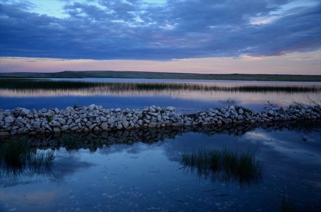
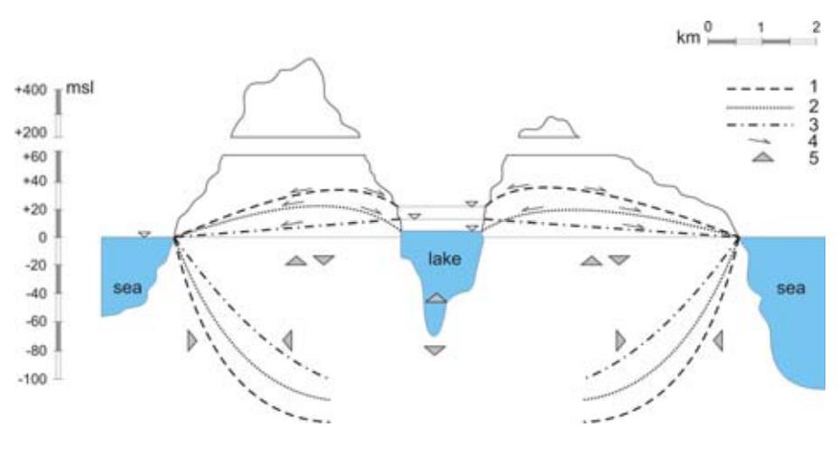
Veliko blato je jezero, stalno ispunjeno vodom, površine oko 1,3 km2 . Prema prosječnoj razini jezerske vode (od 0,5 m do 2,36 m) i dnu jezera (- 1,8 m). Veliko je blato kriptodepresija. Uz stalne i povremene tokove te brojne izvore, u njemu su pohranjene najveće količine slatke vode na otoku. Kako nema potvrđene izravne veze s morem,salinitet je jezera manji (jezero se zaslanjuje uglavnom posolicom) pa je jezerska voda, uz ostalo, iskorištavana i za napajanje brojne stoke na otoku. Kriptodepresija je kada je površina jezera iznad razine mora, dok je dno jezera ispod razine mora.
Na oblikovanje krajolika značajno je utjecala prirodno-geografska osnova prostora, ponajprije krški reljef modeliran u karbonatnim stijenama te bura, prevladavajući vjetar koji je utjecao na razvoj biljnog pokrova, ali i tijek svakodnevnih društveno-gospodarskih aktivnosti otočana.
Da bi uspješno logirali ova earthcache koji je po sebi prirodni fenomen zbog veličine slatkovodnog jezera na otoku morate odgovoriti na slijedeća pitanja:
- Promotrite okoliš (kamenje) oko jezera. Kakve su boje i oblika (oštri ili glatki? Zašto je to tako? S obzirom na okolinu kakvo je ovo jezero po nastanku?
- Zagledajte se u jezero. Da li se vidi dno jezera, te procijenite dubinu. Ako zamislimo da smo na površini jezera u čamcu (a onda znamo da smo samo pola metra iznad razine mora) da li bi ovo bila prirodna depresija ili nešto drugo?
- Dobro promotrite jezero. Da li se vidi doticaj sa morem? Kako to utječe na salinitet samoga jezera? Objasnite.
- Opcionalno slika sa GPS koordinatama
Odgovore pošaljite na moju e-mail adresu, a NE u Vašem logu! Ne morate čekati na moje potvrđivanje Vaših odgovora. Jednom kada pošaljete Vase odgovore slobodno logirajte pronalazak ovog EarthCachea. Ako Vaši odgovori budu pogrešni ja cu kontaktirati Vas.
Važna napomena: Ako želite ići u razgledavanje cijeloga jezera i ornitološkoga parka treba kupiti ulaznicu u turističkoj zajednici Povljana koja se nalaza na ulazu u Povljanu.
[ENG]
The lake is natural depression on the land filled with water, which has no direct connection with the sea. Most of the lakes are freshwater and are located on northen hemisphere at higher altitudes. Artificial lakes are accumulation pools of hydropower plants, ponds, etc... The parts of the sea separated from the land with sand are not lakes. Depression ( or sunken or depressed) is landform below the surrounding area. If there no possibility of flow out of the water, landform ( depression) is filled up with water, thus creating lakes.
Lakes are divided into:
- tectonic lakes in tectonics depression
- volcanic lakes in craters of volcanoes
- glacial lakes (icebergs)
- karst lakes in karst
- relicted lakes, which have remained from the former larger lakes or seas or dead riverbed,
- sedge lakes,
- river lakes,
- artificial lakes.
Some lakes may disappear in a certain part of the year. These lakes are called intermittent lakes and are typical for karst terrain.
The lakes can be sedimented, so the lakes gradually become wetlands such as swamps or shrubs. There is an important difference between the lowland lakes and mountain lakes. Lowland lakes are calm, less rocky / more sedimentary, have slightly sloping bottom and generally have richer flora. Mulberry lakes and lakes with many herbaceous fishes tend to slow vanishing. The "vanishing" lake (barely noticeable on a human scale) typically has a water edge with extensive plant coverings. They become a new habitat for other plants (such as peat sticks in good conditions) and animals, some of them are very rare. Gradually, the lake closes so that a young peat can form a pond.
At the given coordinates is „Veliko blato“ lake.
„Veliko blato“ is a lake, constant filled with water, about 1.3 km2. According to the average lake water level (0.5 m to 2.36 m) and the bottom of the lake (- 1.8 m). „Veliko blato“ is cryptodepression. With constant and occasional streams and numerous springs, it contains the largest quantities of fresh water on the island. Since there is no confirmed direct connection with the sea, the salinity of the lake is smaller than in the other similar lakes (the lake is salinated mostly with the salt from the air/wind), so lake water, among other things, is also used for supplying numerous cattle on the island. Cryptodepression is when the surface of the lake is above sea level, while the bottom of the lake is below sea level.
Landscape formation was significantly influenced by the natural-geographic basis of space, primarily karst relief modeled in carbonate rocks and north wind called „bura“, the dominating wind that influenced the development of the plant cover, as well as the course of everyday social and economic activities of the islanders.
To successfully log this earthcache which is a natural phenomenon due to the size of the freshwater lake on the island you have to answer the following questions:
- Examine the lake's surroundings (rocks). What is their colour and shape (sharp or smooth)? Why is that so? Judging by the surroundings, what is the lake according to its origin?
- Look into the lake. Can you see the bottom? Assess the depth. If we imagine that we are on the lake's surface in a boat (and we are now only half meter above sea level), is this a natural depression or something else?
- Examine the lake well. Do you see any connection to the sea? How does it affect the salinity of the lake? Explain.
- Optional – a photo with GPS coordinates
Send your answers to my e-mail address and NOT in a log. You don't have to wait for me to approve your answers. Once you send your answers feel free to log the cache as found. If your answers are wrong, I will contact you.
Important notice: If you want to go for a tour of the whole lake and the ornithological park you need to buy a ticket in the Povljana tourist office located at entrance to the Povljana.