Cheyenne County was organized in 1870 from lands ceded by the Cheyenne, Arapaho and Dakota Sioux Indians. The panhandle of Nebraska (where you're standing), is part of the Cheyenne Tableland portion of the Great Plains. Once almost entirely covered by buffalo grass, this region for millennia nourished the American bison. This area's climate is characterized by limited rainfall and is swept by strong winds and has become home to broad wheat fields and sprawling cattle ranches.
The Cheyenne Tableland is a preserved interfluve (a narrow, elongated plateau or ridge between two river valleys) located between the North Platte River and the South Platte River in Western Nebraska and Southeastern Wyoming. There are multiple prehistoric processes that have helped shape this area. These include the White River Group (late Eocene through Oligocene), the Arikaree Group (Oligocene to Miocene) and the Ogallala Group (Miocene through early Pliocene).
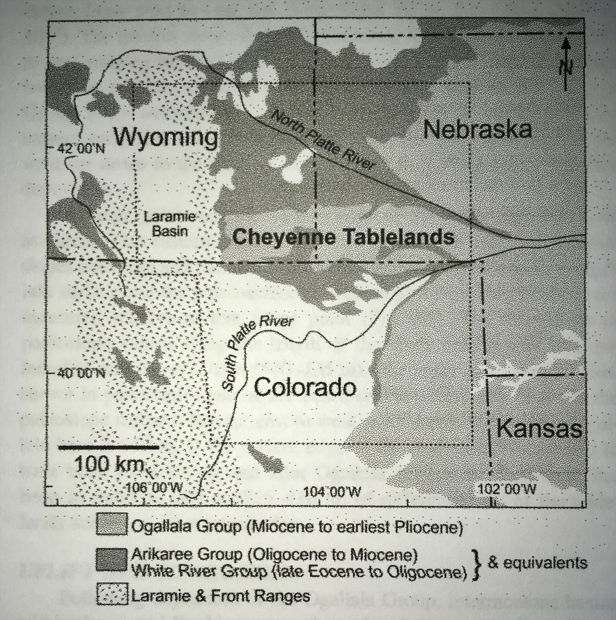
Within this area, fine-grained and tuffaceous fluvial, eolian and lacustrine deposits can be found from the White River and Arikaree groups. The Ogallala Group had more coarse-graied and less tuffaceous deposits and marked the end of aggradation (increases in land elevation due to sediment) and began more of a cut-and-fill and incision as the dominent process that led to geologic changes.
Tuffaceous rocks are rocks that are more than 50% tuff, or volcanic ash that is compacted into a solid rock. Tuff is one of relatively few rocks that can be considered to be part of more than one classification and can be either sedimentary or igneous, though it is usually studied as igneous petrology.
Fluvial processes are associated with rivers and streams and the deposits and landforms created by them.
Eolian deposits and formations are found due to the winds in the area. These deposits and formations are caused through wind and weather affecting the geology of the area by transporting materials from one area and depositing in other areas. This most commonly occurs in areas with sparce vegetation, a lack of soil moisture and a large supply of unconsolidated sediments.
Lacustrine plains (or lake plains) are lakes that over time, become filled in by incoming sediment. This can be through natural drainage, evaporation or other geophysical processes. The soil that is sleft behind constitutes fertile and productive farm land.
All answers must be submitted to the owner of the earthcache to claim credit. Any finds without providing information will be deleted. Please submit answers either through email or through the message feature.
1) With tuffaceous rock being present, what likely happened in this area in prehistoric times?
2) Looking at the area, do you think that the primary geophysical process here was lacustrine, fluvial or eolian? What do you see that makes you think that?
3) In the 1890s, grasshoppers and another natural phenomonen caused homesteaders to leave. If the other phenomenon had continued until today, which of the above processes would have become the primary force shaping the land? How would that have changed what you see here today?
4) What do you estimate the elevation change is from the posted coordinates to the lowest point in the rest area? You can either take GPS readings or estimate the elevation change without leaving the sidewalk.
5) Feel free to post pictures as long as they do not provide answers to the questions (OPTIONAL)
References:
http://geofaculty.uwyo.edu/heller/Papers/McMillan%20GEOL%2002.pdf