If you said "What a pretty kettle of dogs!", you'd be right! Bring along your four-legged friends, because Moore's Meadow is not just a geological kettle, it's an off-leash under-control dog park.
Moore's Meadow is one of a series of parks in the Prince George region that are the result of the glacial lake that helped to form the unique geography of the area. The Prince George bowl region is known geologically as pitted outwash. During the last ice age, glaciers filled the Prince George area, grinding down most of the region. The bowl region of Prince George became a sub-glacial lake, with sediment layering in the bottom of the bowl. The sub-glacial lake was created as a result of an ice dam. When the ice dam released, the rapid draining of the region deposited sediment in the Prince George bowl, which is an outwash plain, also known as a sandur (or sandr, or sandar).
The floods which result in the rapid deposition of significant silt, often the result of the breaking of an ice-dam, are jökulhlaups. Large blocks of ice that had calved from the glaciers became grounded, and the sediment deposits from the river covered them. The sediments acted as a layer of insulation, preserving the block of ice. Because the ice block remained embedded, the sediments formed a level ground over top of the ice block.
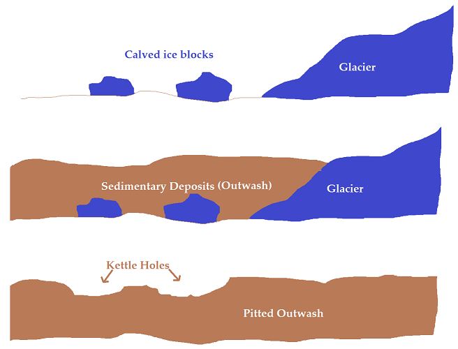
Image is custom made. Feel free to reuse. No attribution required.
When the ice blocks eventually melted, the retreating water created a hollow underneath the sediment which formed into a valley. A valley formed by a glacial block becoming embedded in sediment and eventually melting to create the valley is known as a kettle. As the sign indicates, areas where kettles occur are known as pitted outwash. The outwash is the river of the glacial waters, and the pitted surface results from the glacial blocks.

© Hans Hillewaert / , via Wikimedia Commons
Kettles are usually shallow, rarely reaching a depth of more than 10m (33ft). The kettles often fill in with sediment, and the type of sediment determines whether the kettle becomes a kettle bog (acid conditions) or a kettle peatlands (alkaline conditions). A kettle that fills becomes a kettle lake; however, the sediment deposited in Moore's Meadow prevent it from becoming a kettle lake. The kettle of Moore's Meadow is special due to its size, which also allows the formation of micro-climates. One side of the meadow is primarily dry and sunny, while the other side of the meadow is primarily shaded, cool and moist.
Kettles are just one of the many examples of glacial processes around the Prince George area. Drumlins abound, and the nearby Eskers Provincial Park provides wonderful hiking along the sand ridges of the eskers. For more information on Eskers Provincial Park, check out http://www.env.gov.bc.ca/bcparks/explore/parkpgs/eskers/, and don't forget to do the Earthcache on glacial eskers there: GC4MV0Q Eskers Park Earthcache.
To log this Earthcache, you must email or message me the answers to the following questions. Logs without accompanying answers will be deleted. Do not put your answers in the logs. You do not need to wait to hear from me after emailing to claim the Earthcache.
Questions
1) How long ago did the glacial meltwater create the deposits?
2) According to the sign, how deep is the kettle of Moore's Meadow?
3) According to the sign, what sedimentary deposit allows the water runoff to drain?
4) Name two other parks in the Prince George region that are the result of kettles.
5) Take a walk along both side trails in the valley. What differences do you see in the composition of the ground where it breaks through the grass?
Remember that I'm not trying to judge people for getting the answers exact. I'm more interested in knowing people are going out to the location and engaging with the concepts involved. Don't worry about being 'wrong' - use what you know and make a solid effort. Earthcaches are supposed to be fun. :-)
References
CK12 Foundation. (2017). Deposition by Glaciers. Accessed Jun. 02, 2017 from https://www.ck12.org/earth-science/Deposition-by-Glaciers/lesson/Deposition-by-Glaciers-MS-ES/?referrer=featured_content.
Wikipedia. (Last updated May 30, 2017 at 13:07). Kettle (landform). Accessed Jun. 02, 2017 from https://en.wikipedia.org/wiki/Kettle_(landform)
Wikipedia. (Last updated Mar. 23, 2017 at 12:40). Outwash Plain. Accessed Jun. 02, 2017 from https://en.wikipedia.org/wiki/Outwash_plain.
Wikipedia. (Last updated Mar. 4, 2017 at 07:21). Subglacial Lake. Accessed Jun. 02, 2017 from https://en.wikipedia.org/wiki/Subglacial_lake