Introduction
Many people who walk around Coombes Edge mistakenly believe the edge is the consequence of quarrying years ago. The curved edge and basin beneath in many ways looks like the shape of a quarry and the exposed rock all around the edge looks a little like you would see in a quarry, at least if you look from a distance. The lumps of earth below the edge look like spoil heaps and there appears to be evidence of man tampering with nature, such as ridges, small pools and irregular landscape. So it is easy to understand why people arrive at this conclusion.
The problem is, this conclusion is completely wrong, Coombes Edge has formed completely naturally, in fact the instability of the edge makes it unsuitable for quarrying (although there has been occasional small scale rock removal in a couple of places). This earthcache has been created to explain the unusual geology of Coombes Edge.
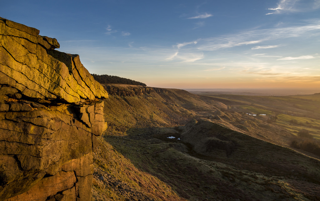
The reality is that Coombes Edge has formed as a result of a large natural landslide. If you have walked right around the edge from Charlesworth, you will have started at the bottom and climbed up to the main edge which is here at GZ, where the large sandstone rocks are jutting out. Even up here, you can see the problem if you look closely. The land below Coombes Edge Rocks consists of relatively weak mudstone and shales which are overlain by massive, gently dipping sandstones. So perhaps the basic problem is already becoming obvious...big heavy rocks, at an angle, on a weak base – but this isn’t uncommon. Why was there such a large landslip here creating this unique curved ridge? This will be explained if you read on.
Please try and read through the information, every effort has been made to make sure the information can be understood without any prior geological knowledge, and you do not need any previous geological knowledge to attempt this earthcache. When you have read through the information, you need to answer a few questions at the end (by sending me the answers via my profile) and this allows you to claim a find on the earthcache. Please note, you do need to send in your answers in order to claim a find.
Background Geology of the Rocks Beneath Your Feet
Below the sandstone is weak strata of shale and mudstone, trying desperately to support the weight of a large cap rock. By its very nature, the instability of the slope is always likely to result in small landslips causing the big rocks to fall, but how this actually occurs has to be determined by quite local conditions. In some cases, it is blatantly obvious - for instance, where a stream is undercutting a valley side so it washes away the mudstone and shale and the sandstone falls – and there are plenty of earthcaches which look at such situations. However, somewhere like Coombes Edge, such a large scale landslip is usually the result of exceptional site conditions which cause a more rapid physical and chemical deterioration of the rock material than is found to occur elsewhere.
Some years ago, a detailed study of the rock layers below you was conducted by following one of the tributaries of the River Etherow, a stream that begins up here and has cut through the rock allowing geologists to see all the layers. And they found below your feet the following -
- Firstly, you are stood next to Rough Rock Sandstone, 50ft thick
- Below that is Mudstones, 70ft thick
- Below that is Rough Rock Flags (sandstone), 30ft thick
- Below that is Shales, 130ft thick
- Below that is the Simmondley Coal Seam, 2-5ft thick
- Below that are more Shales, 20ft thick
- Finally you find Huddersfield White Rock, 130ft thick
The floor of the valley is veneered with Newer Drift boulder clay and this demonstrates that the valley itself was already in existence prior to glaciation.
Coombes Edge is a 'cuesta' - this is a ridge where a harder sedimentary rock overlies a softer layer, the whole being tilted somewhat from the horizontal. This results in a long and gentle backslope called a dip slope that in this case, falls west-north-westwards at an angle of some 7 degrees. Where erosion has exposed the frontslope of this, a steep slope or escarpment occurs. The resulting terrain may be called scarpland
So basically, what this means is the layer of sandstone that forms the edge in front of you here is not flat, it has been tilted by geological events long ago. And because it is not flat, it increases the likelihood of it slipping. The escarpment (the edge you see here at GZ) is formed by a massive sandstone outcrop recognised geologically as the Rough Rock, it is extremely heavy and putting a lot of pressure on the weaker mudstone below it.
So how was Coombes Edge formed?
Coombes Edge as we see it today was formed by a large landslip. Coombes Edge is terminated on the south side by a large fault. A fault is a fracture in the rock along which movement takes place. At some point in the past, this fault moved and when it did it created stresses in the surrounding rock. The fault movement caused widespread fissuring of the mudstone and shales, or put more simply, it caused lots of cracks in the weaker stone which lie under the big rocks you see here at GZ. This previously impermeable (water resistant) stone became, because of the fault movements, readily penetrated by underground waters.
This then caused the relatively rapid deterioration of the stone to take place at a considerable depth below the surface. Coombes Edge is 396m high and the landslides took place at an elevation of 245-305m, well beneath the surface, where underground water was eroding the stone. Eventually the weakened rock slipped downwards and Coombes Edge was formed, more or less as you see it today.
As we mentioned earlier, below Coombes Edge you see an unusual collection of ridges, hummocks and generally very irregular relief beneath a steep cliff face which is curved (bow shaped) in plan. This was all caused by the landslip and is consistent with what you would expect to find here after such an event, a lot of features are still untouched since it occurred. The morphology diagram below shows visually the changes made to the landscape after the landslide occurred, and as you look down from this earthcache (you are currently stood between C & D on the diagram) you can still see many of these features today.
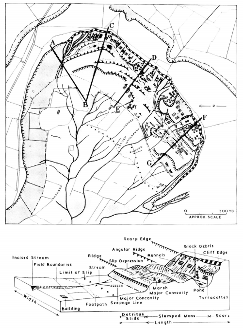
The morphology of the Coombes Edge landslides
Since the main landslip, there has been little further movement. Of course on going erosion continues, so you will find a number of rockfalls along the main scar. Today, minor slip movements resulting in the formation of terracettes is the more common process by which debris is moved down the cliff face. A terracette is a type of landform, a ridge on a hillside formed when saturated soil particles expand, then contract as they dry, causing them to move slowly downhill, and this will slowly disturb the sandstone edge above causing rocks to fall. These are shown visually on the diagram above, and also on the photograph below. The terracettes on the photograph are on a much bigger scale than here at Coombes Edge, but you can clearly see the sort of thing you are looking for.
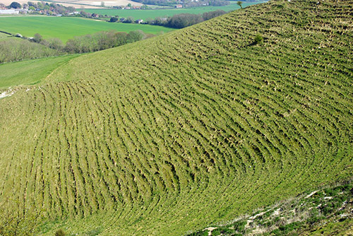
Terracettes on a big scale, you can spot smaller examples on Coombes Edge
You might look at the other half of Coombes Edge and see a slight difference in the edge and the land below the edge. This is because there was more than one landslip here, the entire edge was created in a couple of separate landslips.
Why is it called Coombes Edge?
Coombes Edge has always been the name of this ridge, with Coombes Farm and Far Coombes both nestled down below the edge. And there is a geological reason for this name. The landslips have caused a broad open vale or 'coombe' to be excavated in the shales and mudstones exposed beneath the Rough Rock which forms Coombes Edge. A ‘combe’ or ‘coombe’ is defined as “a short valley or hollow on a hillside or coastline”. They tend to be associated with the South of England, but clearly the term has become permanently associated with this area many years ago.
Logging Requirements (Questions to Answer)
In order to log a find on this earthcache, you must answer the below questions and send me the answers via the link above, or the 'send answers' option if using the official app. Please try to send the answers at the same time as submitting your log, or soon afterwards. If your answer is not received within a reasonable timeframe, your log may be deleted. I always read the answers sent to me and always try and reply. There is no need to wait for a response before submitting your log. Please note, you do not need to have any prior geological knowledge, please just give your best attempt at the answers.
Whilst you can primarily focus your answers on the rock you see directly at GZ, you are also welcome to study any rock elsewhere around Coombes Edge and use any evidence you see elsewhere along the edge to answer the below questions. Please remember some of the rock here may be unstable. Although some questions ask you to look for unstable rock you should do so from a safe distance. Avoid climbing on the rocks around here due to the weak mudstone below them.
Q1 Examine the exposed ‘Rough Rock’ sandstone rock that forms the escarpment here that is known as Coombes Edge. Describe the texture and colour, and also the shape of the rock. Mention evidence of natural weathering directly to the rock from the elements if you see any. Explain why after a close inspection you can confirm the rock edge is naturally formed and not influenced by man.
Q2 Please examine the approximate angle of some of the rocks on the edge. We know the natural tilt should be 7 degrees but near the edge you may see different angles. Do you see any rocks that appear to be tilted at 7 degrees? Do you see any rocks that are clearly not at 7 degrees (less/more)? If so, what angle are they (roughly, no need to climb on the rocks) and why do you think this may be? Please look for natural weaknesses in the rock. Can you see rocks that you believe fall in the future? Why do you say that and how long do you think they may last before they do fall?
Q3 Now look below the rock edge further down the edge to the mudstone and shale layers. Can you see any terracettes that have formed? If so, can you describe one (shape/width/length etc)? The listing explains what a terracette is, if you don’t know.
Q4 Although it has largely weathered away now, a few years ago 'no climbing' was painted onto a number of the rock outcrops here to deter climbers. This wasn't due to the landowner being difficult, it was due to the geological dangers of the area. Please name 2 different geological reasons this edge would be potentially unsafe for climbers.
Optionally, please include a photo of yourself and/or GPSr with the escarpment in the background. This is optional, but is useful as it provides additional proof of your visit.
Please enjoy your visit to Coombes Edge.