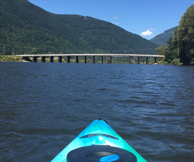
From there kayak or row to stage 2 which is the Dewdney Bridge. At stage 2 find a small, white metal sign mounted on a cross beam on top of the third set of wooden pilings (counted from the north side). Coords are approx. as I couldn't get a reading that was more accurate than 12 metres. I uploaded a photo with treefoil pointing to the small sign at the bottom of the cache page. You may want to bring binoculars if you do not have average vision. A cacher noted that with very good binoculars you may spot a nearly invisible "G" in front of the four letters that are needed for the second stage. Please ignore the "G". Note: The sign is not visible from the top of the bridge.
For stage 3 (final), take the 4 letters at the top of the sign and convert them to numbers (A=1, etc.) Then do this simple math. A, B, C and D represent the letters on the sign.
N 49 0 (B-1).C (D-2) B
W 122 (B+1). (A/2) (C-2) (D-5)
Difficulty/Terrain rating is based on finding/reading the sign and boat that is required.
Congratulations to morliemorlie for the FTF on July 12, 2017! Happy boating!
Nicomen Slough is a narrow stretch of water surrounding Nicomen Island, and is a popular bird-watching destination, especially for Trumpeter swans. Other wildlife inhabiting this area includes spawning salmon and bald eagles. Directions coming from Mission: After you pass the Dewdney General Store built in 1904 and just before the bridge, River Road leads off to the right and follows the shoreline of Nicomen Slough past a pub to Dewdney Nature Park, where there’s a vehicle boat launch. The Fraser River flows past just beyond sight, a short distance south of the boat launch. This is a languid section of the river where a series of sloughs forms backwaters away from the river’s main course. Strawberry Island lies at the east end of Nicomen Slough. (In the 1930s, strawberries were a major cash crop in the Hatzic area.) This is one of the quietest backwaters between here and the eastern end of the Fraser Valley.